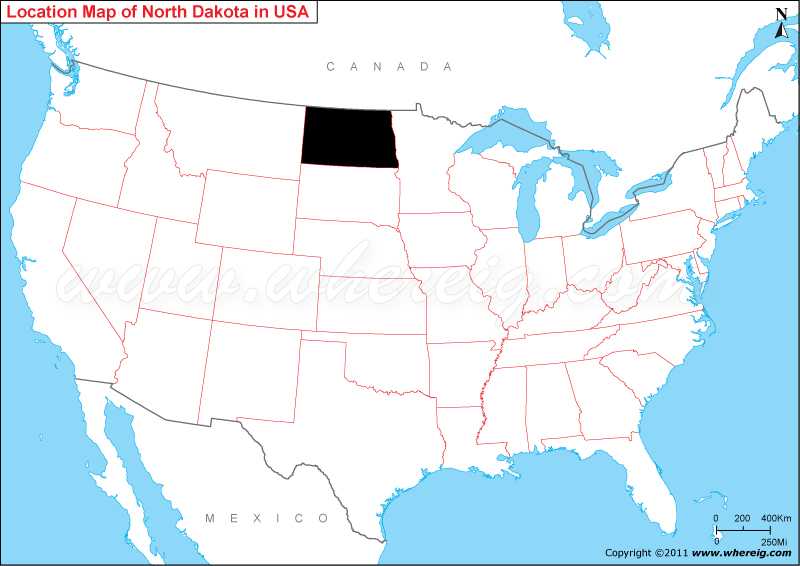
Map showing location of North Dakota on the US map.
The capital city of state is Bismarck; however, the largest city is Fargo. Other important cities are Grand Forks, Minot, West Fargo, Mandan, Dickinson, Jamestown, and Williston. The climate type of North Dakota is Continental.
Economy of North Dakota is largely depends upon agriculture; however, the other important industries are petroleum and food processing.
Surprisingly, North Dakota is the only state of the United States that lawfully demands its pharmacies to have more than 50% shares owned by pharmacists.
Where is North Dakota Located?
As shown in the North Dakota location map that North Dakota is located in the northern side of the United States. North Dakota map also illustrates that it shares its border with the Minnesota in the east, South Dakota in the south, and Montana in the west. Besides, in the north of state, it also shares international boundary with Canada.The capital city of state is Bismarck; however, the largest city is Fargo. Other important cities are Grand Forks, Minot, West Fargo, Mandan, Dickinson, Jamestown, and Williston. The climate type of North Dakota is Continental.
Economy of North Dakota is largely depends upon agriculture; however, the other important industries are petroleum and food processing.
Surprisingly, North Dakota is the only state of the United States that lawfully demands its pharmacies to have more than 50% shares owned by pharmacists.
More North Dakota Maps & Info
North Dakota State - Quick Facts
| Country: | United States |
| Region Type: | State |
| Capital: | Bismarck |
| Abbreviation: | ND, US-ND |
| Largest City: | Fargo |
| Area: | 70,700 sq mi (183,272 km2) |
| Population: | 779,094 (2020 Census) |
| Joined The Union: | -3710 |
| Nickname: | Peace Garden State, Roughrider State, Flickertail State |
| Highest Point: | White Butte |
| Lowest Point: | Red River of the North |
| Timezone: | UTC -6/-5 |
| Official Website: | www.nd.gov |
Location Map of USA with States
- Where is Alabama (AL)
- Where is Alaska
- Where is Arizona
- Where is Arkansas Location Mapp
- Where is California
- Where is Colorado
- Where is Connecticut
- Where is Delaware
- Where is Florida
- Where is Georgia
- Where is Hawaii
- Where is Idaho State Map
- Where is Illinois
- Where is Indiana
- Where is Iowa
- Where is Kansas
- Where is Kentucky
- Where is Louisiana
- Where is Maine
- Where is Maryland
- Where is Massachusetts
- Where is Michigan
- Where is Minnesota
- Where is Mississippi
- Where is Missouri
- Where is Montana
- Where is Nebraska
- Where is Nevada
- Where is New Hampshire
- Where is New Jersey
- Where is New Mexico
- Where is New York
- Where is North Carolina
- Where is North Dakota
- Where is Ohio
- Where is Oklahoma
- Where is Oregon
- Where is Pennsylvania
- Where is Rhode Island
- Where is South Carolina
- Where is South Dakota
- Where is Tennessee
- Where is Texas
- Where is Utah
- Where is Vermont
- Where is Virginia
- Where is Washington
- Where is West Virginia
- Where is Wisconsin
- Where is Wyoming


