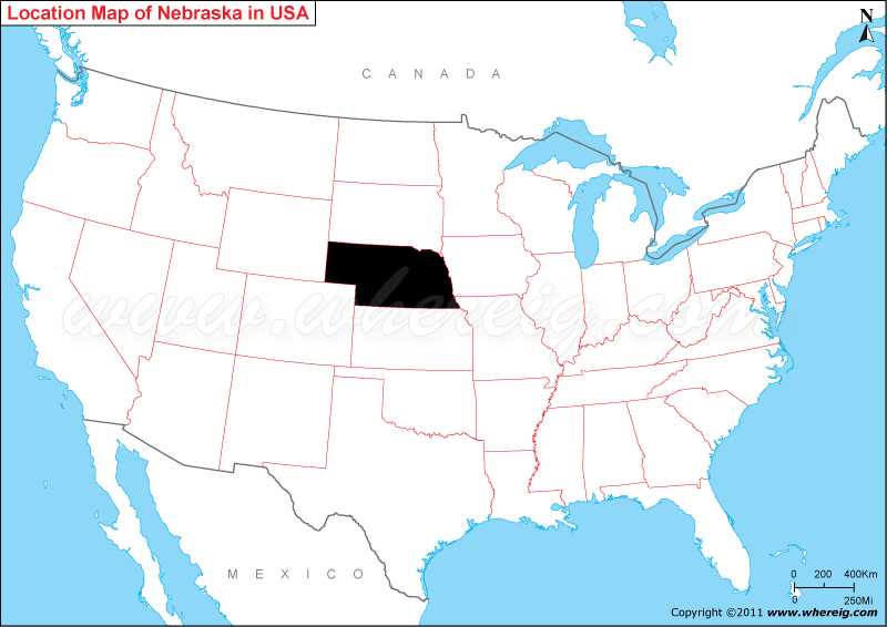
Map showing location of Nebraska located on the USA map?
The capital city of Nebraska is Lincoln; however, its largest city is Omaha. By virtue of being the part of Great Plains, Nebraska is one of the leading farming and ranching states of the US. The climate type of Nebraska ranges from humid continental climate to semi-arid.
Some of the most significant cities of Nebraska are Omaha, Lincoln, Bellevue, Grand Island, Kearney, Fremont, Hastings, and North Platte.
Where is Nebraska State Located?
The given Nebraska location map shows that Nebraska is located in the central part of the US. Map of Nebraska also shows that it shares its state borders with South Dakota in the north, Wyoming in the north-west, Colorado in the south-west, Kansas in the south, Missouri in the south-east, and Iowa in the east. Likewise, Nebraska is located in the Great Plains of Mid-west United States.The capital city of Nebraska is Lincoln; however, its largest city is Omaha. By virtue of being the part of Great Plains, Nebraska is one of the leading farming and ranching states of the US. The climate type of Nebraska ranges from humid continental climate to semi-arid.
Some of the most significant cities of Nebraska are Omaha, Lincoln, Bellevue, Grand Island, Kearney, Fremont, Hastings, and North Platte.
Nebraska State - Quick Facts
| Country: | United States |
| Region Type: | State |
| Capital: | Lincoln |
| Abbreviation: | NE |
| Largest City: | Omaha |
| Area: | 77,354 sq mi |
| Population: | 1,961,504 (2020 Census) |
| Joined The Union: | -11992 |
| Nickname: | Cornhusker State |
| Highest Point: | Panorama Point |
| Lowest Point: | Missouri River at Kansas border |
| Timezone: | UTC−06:00 UTC−07:00 |
| Official Website: | www.nebraska.gov |
Other Nebraska Maps & Info
Location Map of USA with States
- Where is Alabama (AL)
- Where is Alaska
- Where is Arizona
- Where is Arkansas Location Mapp
- Where is California
- Where is Colorado
- Where is Connecticut
- Where is Delaware
- Where is Florida
- Where is Georgia
- Where is Hawaii
- Where is Idaho State Map
- Where is Illinois
- Where is Indiana
- Where is Iowa
- Where is Kansas
- Where is Kentucky
- Where is Louisiana
- Where is Maine
- Where is Maryland
- Where is Massachusetts
- Where is Michigan
- Where is Minnesota
- Where is Mississippi
- Where is Missouri
- Where is Montana
- Where is Nebraska
- Where is Nevada
- Where is New Hampshire
- Where is New Jersey
- Where is New Mexico
- Where is New York
- Where is North Carolina
- Where is North Dakota
- Where is Ohio
- Where is Oklahoma
- Where is Oregon
- Where is Pennsylvania
- Where is Rhode Island
- Where is South Carolina
- Where is South Dakota
- Where is Tennessee
- Where is Texas
- Where is Utah
- Where is Vermont
- Where is Virginia
- Where is Washington
- Where is West Virginia
- Where is Wisconsin
- Where is Wyoming


