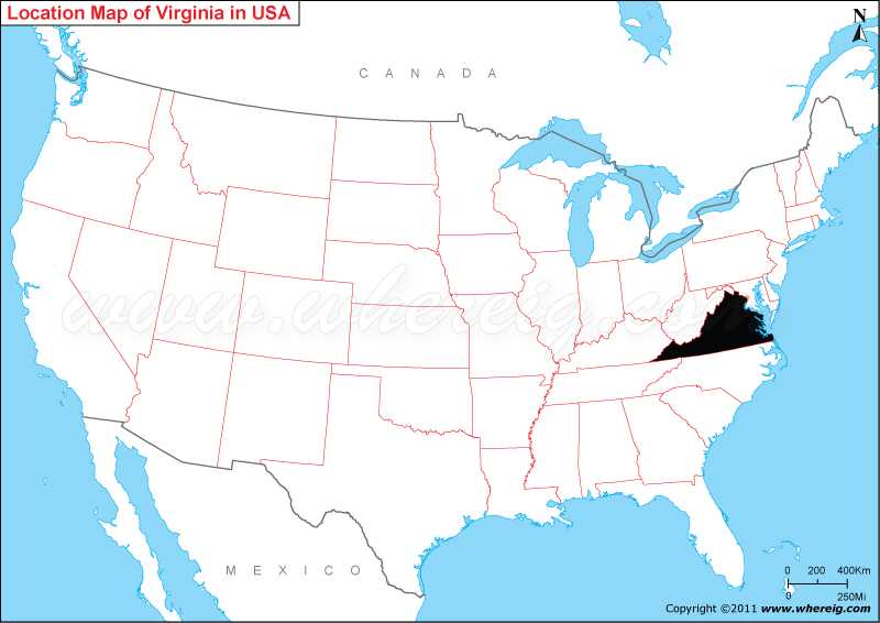
Where is Virginia located on the US map?
As shown in the given Virginia location map that Virginia is located in the eastern part of United States. Virginia map also illustrates that it is the coastal state located on the western Atlantic Ocean. Hence, in the eastern side, it has the coastline along the Atlantic Ocean; however, the state shares its border with North Carolina in the south, Tennessee and Kentucky in the south-west, West Virginia in the west, and Maryland in the north.
Interestingly, the nickname of Virginia is “Old Dominion” and sometimes it is also known by the name “Mother of Presidents” because surprisingly, Virginia is the birth place of 8 US Presidents. The capital city of state is Richmond; however, Virginia Beach is the most populous city and Fairfax County is the most populous political sub-division of the state. Moreover, the Virginia General Assembly is the oldest legislature in the United States.
Due to its geographical location, the climate type of Virginia varies from warm to humid; the warm current Gulf Stream modifies the local weather system of Virginia.
Where is Virginia Located?
As shown in the given Virginia location map that Virginia is located in the eastern part of United States. Virginia map also illustrates that it is the coastal state located on the western Atlantic Ocean. Hence, in the eastern side, it has the coastline along the Atlantic Ocean; however, the state shares its border with North Carolina in the south, Tennessee and Kentucky in the south-west, West Virginia in the west, and Maryland in the north.
Interestingly, the nickname of Virginia is “Old Dominion” and sometimes it is also known by the name “Mother of Presidents” because surprisingly, Virginia is the birth place of 8 US Presidents. The capital city of state is Richmond; however, Virginia Beach is the most populous city and Fairfax County is the most populous political sub-division of the state. Moreover, the Virginia General Assembly is the oldest legislature in the United States.
Due to its geographical location, the climate type of Virginia varies from warm to humid; the warm current Gulf Stream modifies the local weather system of Virginia.
Virginia State - Quick Facts
| Country: | United States |
| Region Type: | State |
| Capital: | Richmond |
| Abbreviation: | VA, US-VA |
| Largest City: | Virginia Beach |
| Area: | 42,774.2 sq mi (110,785.67 km2) |
| Population: | 8,260,405 (2013 est) |
| Joined The Union: | -40729 |
| Nickname: | Old Dominion; Mother of Presidents, Mother of states |
| Highest Point: | Mount Rogers |
| Lowest Point: | Atlantic Ocean sea level |
| Timezone: | Eastern: UTC −5/−4 |
| Official Website: | www.virginia.gov |
Location Map of USA with States
- Where is Alabama (AL)
- Where is Alaska
- Where is Arizona
- Where is Arkansas Location Mapp
- Where is California
- Where is Colorado
- Where is Connecticut
- Where is Delaware
- Where is Florida
- Where is Georgia
- Where is Hawaii
- Where is Idaho State Map
- Where is Illinois
- Where is Indiana
- Where is Iowa
- Where is Kansas
- Where is Kentucky
- Where is Louisiana
- Where is Maine
- Where is Maryland
- Where is Massachusetts
- Where is Michigan
- Where is Minnesota
- Where is Mississippi
- Where is Missouri
- Where is Montana
- Where is Nebraska
- Where is Nevada
- Where is New Hampshire
- Where is New Jersey
- Where is New Mexico
- Where is New York
- Where is North Carolina
- Where is North Dakota
- Where is Ohio
- Where is Oklahoma
- Where is Oregon
- Where is Pennsylvania
- Where is Rhode Island
- Where is South Carolina
- Where is South Dakota
- Where is Tennessee
- Where is Texas
- Where is Utah
- Where is Vermont
- Where is Virginia
- Where is Washington
- Where is West Virginia
- Where is Wisconsin
- Where is Wyoming


