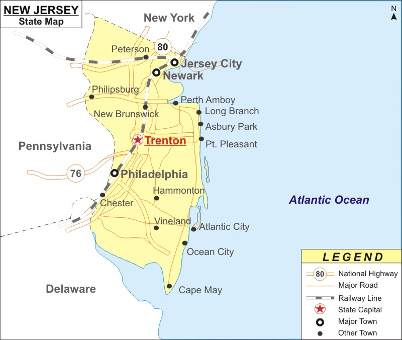
Nicknamed as "The Garden State", New Jersey is a Northeastern state of the United States. It is the 11th most populous state in the US with 8,882,190 residents as of 2019 and the most densely populated state of the 50 states of the US. New Jersey is bordered by New York, Delaware and Pennsylvania.
Map of New Jersey with Cities, Roads, Rivers, Highways
 About Map: New Jersey Map showing the capital, state boundary, roads, rail network,rivers, interstate highways, major cities and towns.
Other New Jersey Maps & Info
About New Jersey State Map
New Jersey is a state in the Mid-Atlantic region of the Northeastern United States. New Jersey is the fourth-smallest state by area an area of 8,722.58 square miles. New Jersey is one of the wealthiest state in the US.
New Jersey state map shows that New York, Pennsylvania and Delaware are the three states bordering it. The fourth side of New Jersey state is bordered by the Atlantic Ocean. NH80 and NH 76 are the two national highways passing through this state. Perth Amboy, Long Branch, Asbury Park, Pt. Pleasant, Atlantic City, Ocean City and Cape May are few cities bordering the Atlantic City depicted on this New Jersey state map. Also, Philadelphia, Newark and Jersey City are the three major towns highlighted on this map.
New Jersey Interstates Highways:
US Highways and State Routes in New Jersey:
Route 60, Route 70, Route 89, Route 89A, Route 93, Route 95, Route 160, Route 180 and Route 191.
New Jersey State Information
| State Name | New Jersey |
| Country | United States |
| Continent | North America |
| Capital City | Trenton |
| Largest city | Newark |
| Largest Metro | Greater New York |
| Abbreviation | NJ, N.J. US-NJ |
| Joined the Union | December 18, 1787 (3rd) |
| Nickname | Garden State |
| Area | 8,722.58 sq mi (22,591.38 km2) |
| Timezone | Eastern: UTC -5/-4 |
| Population | 8,882,190 [11th](as of 2019) |
| Density | 1,210.10/sq mi (467/km2)[1st] |
| Highest Point | High Point |
| Lowest Point | Atlantic Ocean |
| Airport | Newark Liberty International Airport (EWR) |
| Official Website | www.nj.gov |
Places to Visit in New Jersey:
| Liberty State Park | Borgata | Essex County Turtle Back Zoo | Barnegat Lighthouse State Park | Palisades Interstate Park |
| George Washington Bridge | Atlantic City Boardwalk | Casino Pier & Breakwater Beach | Paterson Great Falls National Historical | Morristown National Historical Park |
| Six Flags Great Adventure | Liberty Science Center | Thomas Edison National Historical | Jenkinson's Aquarium | Allaire State Park |
| Hard Rock Hotel & Casino Atlantic City | Boardwalk | Resorts Casino Hotel | Gillian's Wonderland Pier | Cheesequake State Park |
| Steel Pier | Absecon Lighthouse | Storybook Land | Branch Brook Park | New Jersey Botanical Garden |
| Morey's Piers & Beachfront Water | Cape May County Park & Zoo | Kingda Ka | Jenkinson's Boardwalk | High Point State Park |
| Adventure Aquarium | Ocean Casino Resort | The Newark Museum of Art | Van Saun County Park | South Mountain Reservation |
| Cape May Lighthouse | Grounds For Sculpture | Sandy Hook | Sahara Sam's Oasis Outdoor Waterpark | Duke Farms |
- Where is Akron
- Where is Anaheim
- Where is Anchorage
- Where is Arlington
- Where is Aurora
- Where is Baltimore
- Where is Baton Rouge
- Where is Birmingham
- Where is Boise City
- Where is Boston
- Where is Buffalo
- Where is Chandler
- Where is Charlotte
- Where is Chesapeake
- Where is Chula Vista
- Where is Cincinnati
- Where is Cleveland
- Where is Colorado Springs
- Where is Columbus
- Where is Corpus Christi
- Where is Des Moines
- Where is Detroit
- Where is Durham
- Where is El Paso
- Where is Fayetteville
- Where is Fort Wayne
- Where is Freemont
- Where is Fresno
- Where is Garland
- Where is Gilbert
- Where is Glendale
- Where is Greensboro
- Where is Henderson
- Where is Hialeah
- Where is Honolulu
- Where is Houston
- Where is Indianapolis
- Where is Irvine
- Where is Irving
- Where is Jacksonville
- Where is Jersey City
- Where is Kansas City
- Where is Laredo
- Where is Lincoln
- Where is Long Beach
- Where is Louisville
- Where is Lubbock
- Where is Madison
- Where is Memphis
- Where is Mesa
- Where is Milwaukee
- Where is Minneapolis
- Where is Modesto
- Where is Montgomery
- Where is Nashville
- Where is Newark
- Where is Norfolk
- Where is North Las Vegas
- Where is Oakland
- Where is Oklahoma City
- Where is Omaha
- Where is Orlando
- Where is Paradise
- Where is Philadelphia
- Where is Phoenix
- Where is Portland
- Where is Raleigh
- Where is Reno
- Where is Richmond
- Where is Riverside
- Where is Rochester
- Where is Sacramento
- Where is Saint Paul
- Where is Saint Petersburg
- Where is San Bernardino
- Where is San Jose
- Where is Santa Ana
- Where is Scottsdale
- Where is Shreveport
- Where is Spokane
- Where is St Louis
- Where is Stockton
- Where is Tampa
- Where is Toledo
- Where is Tucson
- Where is Tulsa
- Where is Virginia Beach
- Where is Wichita
