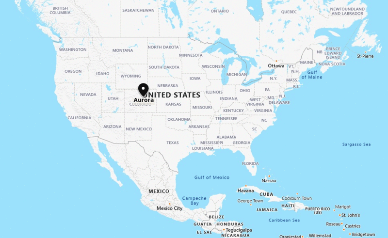
Aurora, Colorado Quick Facts
| Fact | Details |
|---|---|
| City | Aurora |
| County | Arapahoe, Adams, and Douglas Counties |
| State | Colorado |
| State Capital | Denver |
| US Region | West |
| Latitude | 39.7294° N |
| Longitude | 104.8319° W |
| Elevation | 5,471 ft (1,668 m) |
| Land Area | 163.5 sq mi |
| Water Area | 0.8 sq mi |
| Total Area | 164.3 sq mi |
| Population (2020 Census) | 386,261 |
| Population Density | Approximately 2,362 per sq mi |
| ZIP Codes | 80010, 80011, 80012, 80013, 80014, 80015, 80016, 80017, 80018, 80019 |
| Area Code | 303, 720, 983 |
| Time Zone Standard | Mountain Standard Time (MST, UTC-7) |
| Time Zone Daylight | Mountain Daylight Time (MDT, UTC-6) |
| Currency | US Dollar (USD) |
| FIPS Code | 08-04000 |
| Congressional District | Colorado 6th Congressional District |
Location and Surroundings
Aurora is located immediately east of Denver in the Denver metropolitan area of Colorado. It extends across Arapahoe, Adams, and Douglas counties and lies near the South Platte River Basin and the Front Range of the Rocky Mountains. The city is known for its diverse population, healthcare and bioscience industries, military presence, and extensive park system.
Nearby Cities to Aurora, Colorado
- Denver, Colorado - 10 mi West
- Glendale, Colorado - 6 mi West
- Englewood, Colorado - 10 mi Southwest
- Centennial, Colorado - 12 mi South
- Parker, Colorado - 15 mi Southeast
- Commerce City, Colorado - 12 mi North
- Thornton, Colorado - 18 mi North
- Lakewood, Colorado - 18 mi West
- Westminster, Colorado - 19 mi Northwest
- Golden, Colorado - 24 mi West
Aurora, Colorado Climate and Weather Overview
| Month | Avg High (°F) | Avg Low (°F) | Avg Rainfall (in) |
|---|---|---|---|
| January | 45 | 17 | 0.4 |
| April | 62 | 33 | 1.6 |
| July | 89 | 58 | 2.2 |
| October | 65 | 35 | 1.0 |
| Annual | 65 | 36 | 15.0 |
| Climate Attribute | Details |
|---|---|
| Climate Classification (Köppen) | Cold Semi-Arid (BSk) |
| Annual Rainfall | About 15 inches |
| Annual Sunshine Days | Approximately 245 days |
| Hurricane/Tornado Risk | Low hurricane risk, moderate tornado risk |
| Snowfall | Approximately 55 inches annually |
Driving Distances from Aurora, Colorado
| City | State | Distance (mi) | Approx. Drive Time |
|---|---|---|---|
| Denver | Colorado | 10 | 15 min |
| Centennial | Colorado | 12 | 20 min |
| Commerce City | Colorado | 12 | 20 min |
| Parker | Colorado | 15 | 25 min |
| Thornton | Colorado | 18 | 25 min |
| Lakewood | Colorado | 18 | 30 min |
| Westminster | Colorado | 19 | 30 min |
| Golden | Colorado | 24 | 35 min |
| Boulder | Colorado | 35 | 45 min |
| Colorado Springs | Colorado | 68 | 1 hr 10 min |
Transportation and Connectivity in Aurora, Colorado
| Category | Details |
|---|---|
| Airport Name | Denver International Airport |
| IATA Code | DEN |
| Port | Not Applicable |
| Major Highways | I-70, I-225, E-470, US 40, US 287 |
| Train/Amtrak Service | Amtrak service available nearby in Denver |
| Local Bus/Transit Service | RTD Bus and Light Rail Service |
- Interstate 70 - Connects Aurora with Denver, Kansas, and the Rocky Mountains.
- Interstate 225 - Primary beltway connecting Aurora to Denver Tech Center and I-25.
- E-470 - Toll highway linking Aurora with Denver International Airport and southern suburbs.
- US Highway 40 - Historic east-west route through the metro area.
- US Highway 287 - Regional route connecting communities across eastern Colorado.
Key Landmarks and Places to Visit in Aurora, Colorado
| Landmark Name | Type |
|---|---|
| Cherry Creek State Park | State Park |
| Aurora Reservoir | Recreation Area |
| Stanley Marketplace | Entertainment District |
| Plains Conservation Center | Historic Site |
| Morrison Nature Center | Nature Center |
| Wings Over the Rockies Exploration of Flight | Museum |
| Del Mar Park | Urban Park |
| Sand Creek Greenway Trail | Recreation Trail |
| Aurora History Museum | Museum |
| Southlands | Shopping and Entertainment District |
Waterbodies in Aurora, Colorado
Cherry Creek Reservoir, Aurora Reservoir, Quincy Reservoir, Sand Creek, Toll Gate Creek, West Toll Gate Creek, Coal Creek, Senac Creek, Murphy Creek, South Platte River
Golf Courses in Aurora, Colorado
Aurora Hills Golf Course, Murphy Creek Golf Course, Meadow Hills Golf Course, Saddle Rock Golf Course, Springhill Golf Course, CommonGround Golf Course, Fitzsimons Golf Course, Heritage Eagle Bend Golf Club, Valley Country Club, Heather Ridge Golf Club
Economy and Major Employers in Aurora, Colorado
| Sector | Major Employer or Industry | Notes |
|---|---|---|
| Healthcare | UCHealth Anschutz Medical Campus | Major medical and research employer. |
| Military | Buckley Space Force Base | Important defense and aerospace installation. |
| Education | University of Colorado Anschutz Campus | Leading health sciences education center. |
| Retail | Southlands and Local Retail Centers | Supports regional commerce and employment. |
| Technology | Aerospace and Technology Firms | Growing innovation and research sector. |
| Government | City of Aurora | Major public-sector employer. |
| Construction | Residential and Commercial Development | Driven by continued population growth. |
| Logistics | Transportation and Distribution | Benefits from proximity to Denver International Airport. |
Colleges and Universities in Aurora, Colorado
| Institution Name | Type | Level | Notable For |
|---|---|---|---|
| University of Colorado Anschutz Medical Campus | Public | University | Medical and health sciences education |
| Community College of Aurora | Public | Community College | Transfer and workforce training programs |
| Colorado Technical University | Private | University | Business and technology programs |
| Rocky Vista University | Private | University | Osteopathic medicine education |
| Concorde Career College - Aurora | Private | College | Healthcare career training |
| Platt College Aurora | Private | College | Allied health and vocational education |
Aurora, Colorado - Key Historical Facts
- Aurora was founded in 1891 as the town of Fletcher and was renamed Aurora in 1907.
- The city grew rapidly after World War II as Denver's metropolitan area expanded eastward.
- Buckley Air Force Base, now Buckley Space Force Base, played a major role in Aurora's development.
- The establishment of the University of Colorado Anschutz Medical Campus transformed Aurora into a major healthcare and research center.
- Aurora became one of Colorado's most diverse cities through decades of population growth and migration.
- Today, Aurora is Colorado's third-largest city and an important economic center in the Denver metropolitan region.
Sources
- Official City of Aurora Website
- Arapahoe County Official Website
- U.S. Census Bureau
- U.S. Geological Survey (USGS)
- National Weather Service
More CO Maps
US Cities Location
- Where is Akron
- Where is Anaheim
- Where is Anchorage
- Where is Arlington
- Where is Aurora
- Where is Baltimore
- Where is Baton Rouge
- Where is Birmingham
- Where is Boise City
- Where is Boston
- Where is Buffalo
- Where is Chandler
- Where is Charlotte
- Where is Chesapeake
- Where is Chula Vista
- Where is Cincinnati
- Where is Cleveland
- Where is Colorado Springs
- Where is Columbus
- Where is Corpus Christi
- Where is Des Moines
- Where is Detroit
- Where is Durham
- Where is El Paso
- Where is Fayetteville
- Where is Fort Wayne
- Where is Freemont
- Where is Fresno
- Where is Garland
- Where is Gilbert
- Where is Glendale
- Where is Greensboro
- Where is Henderson
- Where is Hialeah
- Where is Honolulu
- Where is Houston
- Where is Indianapolis
- Where is Irvine
- Where is Irving
- Where is Jacksonville
- Where is Jersey City
- Where is Kansas City
- Where is Laredo
- Where is Lincoln
- Where is Long Beach
- Where is Louisville
- Where is Lubbock
- Where is Madison
- Where is Memphis
- Where is Mesa
- Where is Milwaukee
- Where is Minneapolis
- Where is Modesto
- Where is Montgomery
- Where is Nashville
- Where is Newark
- Where is Norfolk
- North Las Vegas
- Oakland
- Oklahoma City
- Where is Omaha
- Where is Orlando
- Where is Paradise
- Where is Philadelphia
- Where is Phoenix
- Where is Portland
- Where is Raleigh
- Where is Reno
- Where is Richmond
- Where is Riverside
- Where is Rochester
- Where is Sacramento
- Where is Saint Paul
- Where is Saint Petersburg
- Where is San Bernardino
- Where is San Jose
- Where is Santa Ana
- Where is Scottsdale
- Where is Shreveport
- Where is Spokane
- Where is St Louis
- Where is Stockton
- Where is Tampa
- Where is Toledo
- Where is Tucson
- Where is Tulsa
- Where is Virginia Beach
- Where is Wichita