
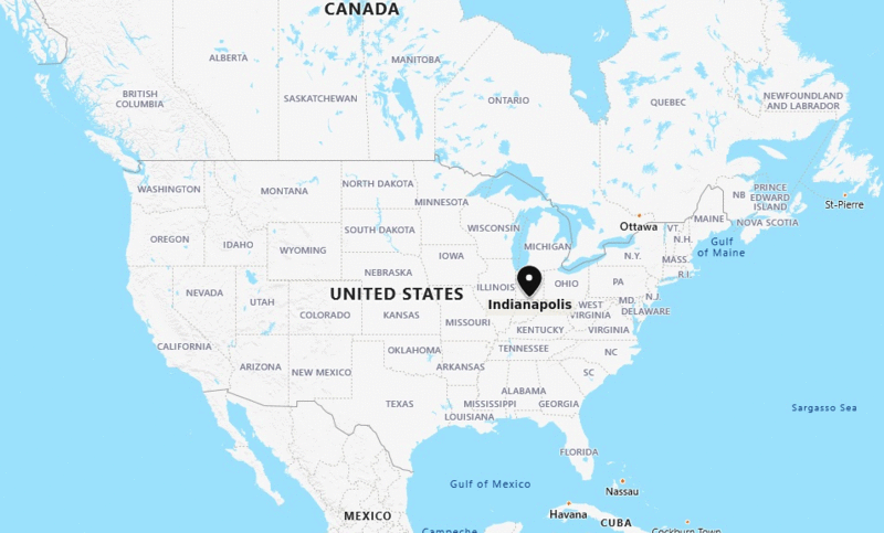
Indianapolis is located in the central part of the Indiana. It is the capital city of Indiana and twelveth largest city in the United States.
Location Map of Indianapolis in Indiana
Indiana Maps & Info
Where is Indianapolis Located?
Indianapolis is a city and county seat of Marion county and capital of U.S. state of Indiana, Indianapolis is in the East North Central region of the Midwestern United States, in central Indiana. It lies on the White River at its confluence with Fall Creek, near the centre of the state.
Indiana was named after Native Americans. Indiana translates as "Indian Territory." Indiana is the first state to have a chapel within its state capitol, which was built in memory of former first lady Beth Bowen.
Indianapolis is a charmingly picturesque city with plenty of greenery, gleaming waterways, and remarkable memorials. Indianapolis City is the third-most populated city in the Midwest and the fifteenth most populous city in the United States. When visiting Indianapolis, one may split one's time between checking in the city's great museums, historical sites, top sporting events, and time spent in nature. Three of the biggest single-day events in the world are held in Indianapolis city and they are the Indy 500, the Brickyard 400, and the U.S. Grand Prix Formula One race. This is why Indianapolis City is referred to as the "racing capital of the world." The largest museum of its sort in the world is the Children's Museum of Indianapolis. The Indianapolis Zoo is home to more than 1,400 animals from 235 species, whereas the nearby White River Gardens include over 50,000 plants in approximately 3,000 different types. A vast collection of auto racing equipment from many motorsports and periods in automotive history are on display at the Indianapolis Motor Speedway Museum.
Foods that are popular in Indianapolis include Breaded Pork Tenderloin, Sugar Cream Pie, Hoosier Chili, Persimmon Pudding, Roast Beef Manhattan, Sweet Corn, Biscuits and Gravy, Zombie Dust and Fried Brain Sandwich.
Some of the best places to visit in Indianapolis City are the Children's Museum of Indianapolis, Eiteljorg, Museum, White River State Park, Holliday Park, Indiana World War Memorial, Soldiers & Sailors Monument, Indianapolis Canal Walk and Eagle Creek Park. Indianapolis City is a home to National Football League known as Indianapolis Colts, National Basketball Association named as Indiana Pacers WNBA is Indiana Fever and United Soccer League called as Indy Eleven.
Places to Visit in Indianapolis:
Following are the list of Top Places to Visit in Indianapolis;
| The Children's Museum of Indianapolis | Eiteljorg Museum | Monument Circle | Indianapolis Canal Walk | Indiana Statehouse |
| Indianapolis Zoo | Indianapolis Motor Speedway Museum | Holliday Park | Indianapolis City Market | Indianapolis Art Center |
| White River State Park | Soldiers & Sailors Monument | Indiana World War Memorial | Garfield Park Conservatory | Geist Reservoir |
| Indianapolis Motor Speedway | Conner Prairie | Monon Trail | Downtown Indy, Inc. | Canal Walk |
| Newfields | Eagle Creek Park | Garfield Park | The Waterpark | Col. Eli Lilly Civil War Museum |
| Indiana State Museum | Fort Harrison State Park | White River Gardens | Indiana Medical History Museum | Greatimes Family Fun Park |
Indianapolis, Indiana Quick Facts
| Fact | Details |
|---|---|
| City | Indianapolis |
| County | Marion County |
| State | Indiana |
| State Capital | Indianapolis |
| US Region | Midwest |
| Latitude | 39.7684° N |
| Longitude | 86.1581° W |
| Elevation | 715 ft (218 m) |
| Land Area | 361.5 sq mi |
| Water Area | 7.0 sq mi |
| Total Area | 368.5 sq mi |
| Population (2020 Census) | 887,642 |
| Population Density | Approximately 2,455 per sq mi |
| ZIP Codes | 46201-46208, 46214, 46216-46220, 46222-46229, 46231, 46234-46237, 46239-46242, 46244, 46247, 46249-46250, 46253-46256, 46259-46260, 46262, 46266, 46268, 46274, 46277-46282, 46283, 46285, 46290, 46298 |
| Area Code | 317, 463 |
| Time Zone Standard | Eastern Standard Time (EST, UTC-5) |
| Time Zone Daylight | Eastern Daylight Time (EDT, UTC-4) |
| Currency | US Dollar (USD) |
| FIPS Code | 18-36003 |
| Congressional District | Indiana 7th Congressional District |
Location and Surroundings
Indianapolis is located in Marion County in central Indiana. It lies between Chicago to the northwest, Cincinnati to the southeast, and Louisville to the south, near the center of the state. The city is known as Indiana's capital, its sports culture, the Indianapolis 500, healthcare and life sciences industries, and its role as a major transportation hub.
Nearby Cities to Indianapolis, Indiana
- Beech Grove, Indiana - 5 mi Southeast
- Speedway, Indiana - 5 mi West
- Lawrence, Indiana - 10 mi Northeast
- Southport, Indiana - 10 mi South
- Carmel, Indiana - 15 mi North
- Fishers, Indiana - 17 mi Northeast
- Noblesville, Indiana - 23 mi Northeast
- Greenwood, Indiana - 12 mi South
- Plainfield, Indiana - 18 mi West
- Brownsburg, Indiana - 18 mi Northwest
Indianapolis, Indiana Climate and Weather Overview
| Month | Avg High (°F) | Avg Low (°F) | Avg Rainfall (in) |
|---|---|---|---|
| January | 36 | 21 | 2.8 |
| April | 63 | 42 | 4.4 |
| July | 85 | 66 | 4.5 |
| October | 66 | 46 | 3.0 |
| Annual | 63 | 44 | 42.0 |
| Climate Attribute | Details |
|---|---|
| Climate Classification (Köppen) | Hot-Summer Humid Continental (Dfa) |
| Annual Rainfall | About 42 inches |
| Annual Sunshine Days | Approximately 186 days |
| Hurricane/Tornado Risk | Low hurricane risk, moderate tornado risk |
| Snowfall | Approximately 22 inches annually |
Driving Distances from Indianapolis, Indiana
| City | State | Distance (mi) | Approx. Drive Time |
|---|---|---|---|
| Beech Grove | Indiana | 5 | 10 min |
| Speedway | Indiana | 5 | 10 min |
| Lawrence | Indiana | 10 | 15 min |
| Southport | Indiana | 10 | 15 min |
| Greenwood | Indiana | 12 | 20 min |
| Carmel | Indiana | 15 | 25 min |
| Fishers | Indiana | 17 | 25 min |
| Plainfield | Indiana | 18 | 25 min |
| Brownsburg | Indiana | 18 | 25 min |
| Noblesville | Indiana | 23 | 30 min |
Transportation and Connectivity in Indianapolis, Indiana
| Category | Details |
|---|---|
| Airport Name | Indianapolis International Airport |
| IATA Code | IND |
| Port | Not Applicable |
| Major Highways | I-65, I-69, I-70, I-74, I-465 |
| Train/Amtrak Service | Amtrak Cardinal |
| Local Bus/Transit Service | IndyGo Bus System |
- Interstate 65 - Connects Indianapolis with Chicago, Louisville, and the Gulf Coast corridor.
- Interstate 69 - Major route linking Indianapolis with northeastern Indiana and Michigan.
- Interstate 70 - Cross-country highway connecting Indianapolis with Columbus and St. Louis.
- Interstate 74 - Provides regional access to Illinois, Ohio, and central Indiana communities.
- Interstate 465 - Beltway surrounding Indianapolis and serving suburban communities.
Key Landmarks and Places to Visit in Indianapolis, Indiana
| Landmark Name | Type |
|---|---|
| Indianapolis Motor Speedway | Sports Venue |
| White River State Park | Urban Park |
| Children's Museum of Indianapolis | Museum |
| Indianapolis Zoo | Zoo |
| Monument Circle | Historic Landmark |
| Indiana State Museum | Museum |
| Eiteljorg Museum | Museum |
| Lucas Oil Stadium | Sports Venue |
| Newfields | Art Museum and Gardens |
| Soldiers and Sailors Monument | Monument |
Waterbodies in Indianapolis, Indiana
White River, Fall Creek, Eagle Creek Reservoir, Geist Reservoir, White River Canal, Pogues Run, Pleasant Run, Crooked Creek, Little Eagle Creek, Morse Reservoir
Golf Courses in Indianapolis, Indiana
Brickyard Crossing Golf Course, Eagle Creek Golf Club, South Grove Golf Course, Riverside Golf Course, Saddlebrook Golf Club, Coffin Golf Club, Pleasant Run Golf Course, Buffer Park Golf Course, Highland Golf and Country Club, Meridian Hills Country Club
Economy and Major Employers in Indianapolis, Indiana
| Sector | Major Employer or Industry | Notes |
|---|---|---|
| Healthcare | Indiana University Health | Largest healthcare system in the state. |
| Pharmaceuticals | Eli Lilly and Company | Global pharmaceutical headquarters. |
| Education | Indiana University Indianapolis | Major higher education and research institution. |
| Logistics | Transportation and Distribution Industry | Benefits from the city's central location. |
| Sports | Professional Sports and Events Industry | Major contributor to tourism and hospitality. |
| Government | State of Indiana | Significant public-sector employer. |
| Manufacturing | Advanced Manufacturing Industry | Supports regional economic growth. |
| Finance | Banking and Financial Services | Important component of the local economy. |
Colleges and Universities in Indianapolis, Indiana
| Institution Name | Type | Level | Notable For |
|---|---|---|---|
| Indiana University Indianapolis | Public | University | Research, medicine, and health sciences |
| Butler University | Private | University | Business, pharmacy, and liberal arts programs |
| University of Indianapolis | Private | University | Healthcare and professional studies |
| Marian University | Private | University | Medical and liberal arts education |
| Ivy Tech Community College Indianapolis | Public | Community College | Workforce training and transfer programs |
| Martin University | Private | University | Adult and minority-focused higher education |
Indianapolis, Indiana - Key Historical Facts
- Indianapolis was founded in 1821 and was specifically planned to serve as Indiana's state capital.
- The city's central location helped it become an important transportation and railroad hub during the nineteenth century.
- The Indianapolis Motor Speedway opened in 1909 and became home to the world-famous Indianapolis 500.
- Manufacturing and automotive industries played major roles in the city's economic development.
- Unigov consolidation in 1970 merged city and county governments, significantly expanding Indianapolis.
- Today, Indianapolis is Indiana's largest city and a major center for healthcare, sports, education, logistics, and business.
Sources
- Official City of Indianapolis Website
- Marion County Government
- U.S. Census Bureau
- U.S. Geological Survey (USGS)
- National Weather Service
- Where is Akron
- Where is Anaheim
- Where is Anchorage
- Where is Arlington
- Where is Aurora
- Where is Baltimore
- Where is Baton Rouge
- Where is Birmingham
- Where is Boise City
- Where is Boston
- Where is Buffalo
- Where is Chandler
- Where is Charlotte
- Where is Chesapeake
- Where is Chula Vista
- Where is Cincinnati
- Where is Cleveland
- Where is Colorado Springs
- Where is Columbus
- Where is Corpus Christi
- Where is Des Moines
- Where is Detroit
- Where is Durham
- Where is El Paso
- Where is Fayetteville
- Where is Fort Wayne
- Where is Freemont
- Where is Fresno
- Where is Garland
- Where is Gilbert
- Where is Glendale
- Where is Greensboro
- Where is Henderson
- Where is Hialeah
- Where is Honolulu
- Where is Houston
- Where is Indianapolis
- Where is Irvine
- Where is Irving
- Where is Jacksonville
- Where is Jersey City
- Where is Kansas City
- Where is Laredo
- Where is Lincoln
- Where is Long Beach
- Where is Louisville
- Where is Lubbock
- Where is Madison
- Where is Memphis
- Where is Mesa
- Where is Milwaukee
- Where is Minneapolis
- Where is Modesto
- Where is Montgomery
- Where is Nashville
- Where is Newark
- Where is Norfolk
- Where is North Las Vegas
- Where is Oakland
- Where is Oklahoma City
- Where is Omaha
- Where is Orlando
- Where is Paradise
- Where is Philadelphia
- Where is Phoenix
- Where is Portland
- Where is Raleigh
- Where is Reno
- Where is Richmond
- Where is Riverside
- Where is Rochester
- Where is Sacramento
- Where is Saint Paul
- Where is Saint Petersburg
- Where is San Bernardino
- Where is San Jose
- Where is Santa Ana
- Where is Scottsdale
- Where is Shreveport
- Where is Spokane
- Where is St Louis
- Where is Stockton
- Where is Tampa
- Where is Toledo
- Where is Tucson
- Where is Tulsa
- Where is Virginia Beach
- Where is Wichita
Written and fact-checked by Whereig.com Web Team | Last Updated: January 11, 2025, 11:50 PM ET