
Written and Fact-checked by Whereig Editors | Last Updated On: June 16, 2026
Where is New Delhi Located on the India Map? Find New Delhi’s location map, coordinates, population, nearby cities, attractions, roads and highways, climate, transportation, and important city facts.
Location Map of New Delhi, India
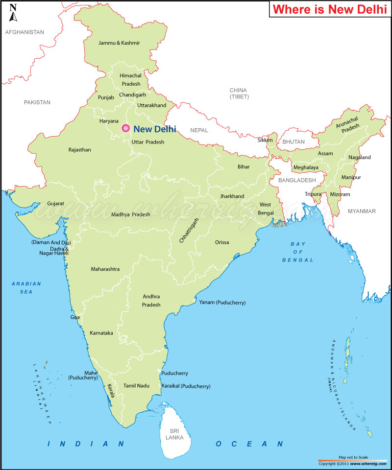
About Map: The map shows the location of New Delhi in the India.
Where is Melbourne Located?
New Delhi is the capital city of India and serves as the center of government of the National Capital Territory of Delhi. Earlier the capital city of India was Kolkata but in the year 1911, New Delhi became the capital city of India.
Besides, city has historic importance and has several structures old as well as new to visit. At present, the city New Delhi is more popularly known for its wide, tree-lined boulevards and flyovers.
Besides, New Delhi is huge commercial, cultural, and social center of India. People from across the country come for various purposes. Above all, the city has so many things and activities that fascinate tourists across the world. Hence, thousands of tourists visit New Delhi every year.
New Delhi, Delhi Quick Facts
| Fact | Details |
|---|---|
| City | New Delhi |
| Union Territory | Delhi |
| Country | India |
| National Capital | New Delhi |
| Region | Northern India |
| Latitude | 28.6139° N |
| Longitude | 77.2090° E |
| Elevation | 709 ft (216 m) |
| Land Area | 16.5 sq mi |
| Water Area | Includes lakes, drains and Yamuna floodplain areas |
| Total Area | 16.5 sq mi |
| Population (Latest Estimate) | Approximately 250,000 |
| Population Density | Approximately 15,000 per sq mi |
| Postal Codes | 110001-110029 and surrounding central districts |
| Area Code | +91 11 |
| Time Zone Standard | Indian Standard Time (UTC+5:30) |
| Time Zone Daylight | No daylight saving time observed |
| Currency | Indian Rupee (INR) |
| Administrative Code | New Delhi Municipal Council (NDMC) |
| Parliamentary Representation | New Delhi Lok Sabha Constituency |
Nearby Cities to New Delhi, India
- Delhi, Delhi - 3 mi North
- Noida, Uttar Pradesh - 9 mi East
- Ghaziabad, Uttar Pradesh - 12 mi East
- Gurugram, Haryana - 18 mi Southwest
- Faridabad, Haryana - 18 mi South
- Bahadurgarh, Haryana - 19 mi West
- Greater Noida, Uttar Pradesh - 25 mi Southeast
- Sonipat, Haryana - 27 mi North
- Meerut, Uttar Pradesh - 44 mi Northeast
- Panipat, Haryana - 57 mi North
New Delhi, India Climate and Weather Overview
| Month | Avg High (°F) | Avg Low (°F) | Avg Rainfall (in) |
|---|---|---|---|
| January | 70 | 46 | 0.8 |
| April | 98 | 68 | 0.3 |
| July | 95 | 81 | 7.0 |
| October | 92 | 67 | 0.7 |
| Annual | 89 | 66 | 31.0 |
| Climate Attribute | Details |
|---|---|
| Climate Classification (Köppen) | Cwa - Humid Subtropical |
| Annual Rainfall | Approximately 31 inches |
| Annual Sunshine Days | Approximately 270 sunny days |
| Hurricane/Tornado Risk | Very Low |
| Snowfall | No snowfall |
Driving Distances from New Delhi, India
| City | State | Distance (mi) | Approx. Drive Time |
|---|---|---|---|
| Delhi | Delhi | 3 | 10 min |
| Noida | Uttar Pradesh | 9 | 20 min |
| Ghaziabad | Uttar Pradesh | 12 | 25 min |
| Gurugram | Haryana | 18 | 30 min |
| Faridabad | Haryana | 18 | 35 min |
| Bahadurgarh | Haryana | 19 | 35 min |
| Greater Noida | Uttar Pradesh | 25 | 45 min |
| Sonipat | Haryana | 27 | 45 min |
| Meerut | Uttar Pradesh | 44 | 1 hr 15 min |
| Panipat | Haryana | 57 | 1 hr 30 min |
Transportation and Connectivity in New Delhi, India
| Airport Name | Indira Gandhi International Airport |
| IATA Code | DEL |
| Port | No Seaport |
| Major Highways | NH 44, NH 48, Delhi Ring Road, Delhi-Meerut Expressway |
| Train Service | Indian Railways and Regional Rapid Transit System |
| Local Transit Service | Delhi Metro, DTC Buses and Local Rail |
- NH 44 - India's longest highway connecting Delhi with northern and southern regions.
- NH 48 - Major corridor linking Delhi with Jaipur, Ahmedabad and Mumbai.
- Delhi Ring Road - Important urban route connecting central and outer districts.
- Delhi-Meerut Expressway - High-speed route serving eastern NCR communities.
- Urban Expressway Network - Connects New Delhi with Noida, Gurugram and Faridabad.
Key Landmarks and Places to Visit in New Delhi, India
| Landmark Name | Type |
|---|---|
| India Gate | War Memorial |
| Rashtrapati Bhavan | Government Building |
| Parliament House | Government Building |
| Lotus Temple | Religious Site |
| Humayun's Tomb | UNESCO Site |
| Qutub Minar | Historic Monument |
| National Museum | Museum |
| Lodhi Garden | Urban Park |
| Akshardham Temple | Religious Site |
| Rajpath (Kartavya Path) | Ceremonial Boulevard |
Places to Visit in New Delhi, India
| Landmark Name | Type |
|---|---|
| India Gate | War Memorial |
| Rashtrapati Bhavan | Government Building |
| Parliament House | Government Building |
| Lotus Temple | Religious Site |
| Humayun's Tomb | UNESCO Site |
| Qutub Minar | Historic Monument |
| National Museum | Museum |
| Lodhi Garden | Urban Park |
| Akshardham Temple | Religious Site |
| Kartavya Path | Ceremonial Boulevard |
Colleges and Universities in New Delhi, India
| Institution Name | Type | Level | Notable For |
|---|---|---|---|
| University of Delhi | Public | University | Higher education and research |
| Jawaharlal Nehru University | Public | University | Social sciences and research |
| Jamia Millia Islamia | Public | University | Multidisciplinary education |
| All India Institute of Medical Sciences | Public | University | Medical education |
| Indira Gandhi National Open University | Public | University | Distance learning |
Waterbodies in New Delhi, India
Yamuna River, Sanjay Lake, Bhalswa Lake, Najafgarh Lake, Hauz Khas Lake, Naini Lake, Sukhna Drain, Barapullah Drain, Neela Hauz, Delhi Canal System
Golf Courses in New Delhi, India
Delhi Golf Club, Qutab Golf Course, Bhalswa Golf Course, Classic Golf & Country Club, Jaypee Greens Golf Course, Golden Greens Golf Club, ITC Classic Golf Resort, Army Golf Course, Noida Golf Course, Karma Lakelands Golf Club
New Delhi, India - Key Historical Facts
- New Delhi was planned by British architects Edwin Lutyens and Herbert Baker as the new capital of British India.
- The city was officially inaugurated in 1931 and replaced Calcutta as the capital of British India.
- Many of India's most important government institutions were established in New Delhi during the colonial period.
- After India's independence in 1947, New Delhi became the capital of the Republic of India.
- The city has hosted numerous national celebrations, international summits and state ceremonies.
- Today, New Delhi serves as India's political center and forms the core of the National Capital Territory of Delhi.
References
- New Delhi Municipal Council
- Government of NCT of Delhi
- Census of India
- Encyclopaedia Britannica - New Delhi