Written and Fact-checked by Whereig Editors | Updated On: May 01, 2026 | 23:55 ET
Punjab, state of India, located in the northwestern part of the India. It is the 20th-largest Indian state by area 50,362 km2 (19,445 sq mi) and 16th-largest state by population (27,743,338). the state is bordered by the Indian union territory of Jammu and Kashmir to the north, Himachal Pradesh to the east, Haryana to the south and southeast, Rajasthan to the southwest. It is bordered by the Pakistani province of Punjab to the west.
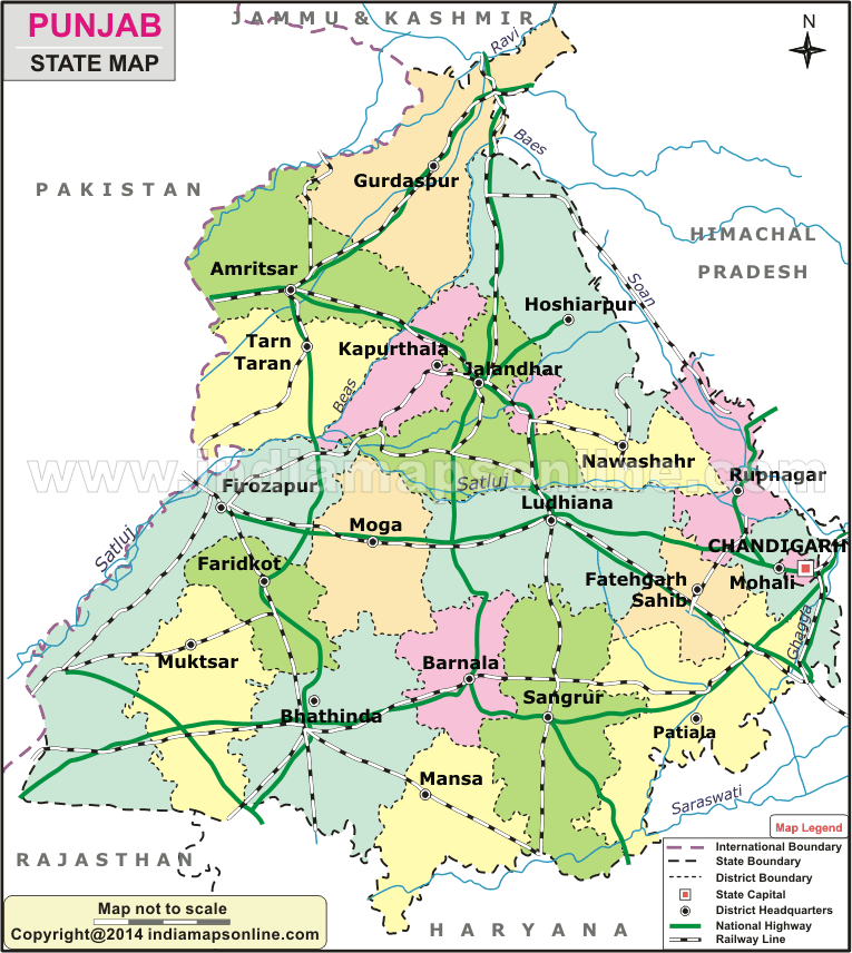
Map of Punjab
 Map Sourse/ partner - indiamapsonline.com
About Map - Punjab map showing state boundary, district boundary, roads, national highways, rail network & state capital.
| Punjab District Map | Where is New Delhi | India Google Map |
| Where is India | Cities in India | Where is Mumbai |
| Airports in India | Where is Bangalore | Where is Hyderabad |
About Punjab Map
Punjab is a state, which is in northwest part of India. It is the most prosperous state in India. Find out more details about Punjab and districts and their borders. Punjab Map, depicts all districts, state capital and neighbouring states, district boundary, roads, national highways, rail network & state capital.
About Punjab
One of the states, which are located in the northwest region of India, is Punjab. Punjab shares the borders with other Indian states like Himachal Pradesh to the north as well as northeast, Haryana is located to the south and southeast, and the state of Rajasthan lies to the southwest, Chandigarh to the east and Jammu and Kashmir to the north. To the West Pakistan borders the state of Punjab. Punjab is the 20th biggest state of India. The state occupies 19,445 square miles in the total arena of India. The state is the sixteenth biggest state in terms of population. The population of the state is 30.49 million. It is estimated population. According to Unique Identification Aadhar India census, the projected population was 30,141,373 by the end of the year 2020. The capital of the state is Chandigarh. Chandigarh is also the capital for the neighboring state Haryana.
Districts of Punjab
For the administrative purpose, the state of Punjab has been divided into 22 districts. These 22 districts of Punjab have been classified geographically into Majha, Malwan Doaba, and Doaba and Poadh. They are officially divided into 5 divisions namely Patiala, Rupnagar, Jalandhar, Faridkot, and Firozepur. Each district of Punjab is governed by a District Collector. These 22 districts of Punjab further divided into 79 tehsils. Tehsils have administrative powers over their region to manage local records, maintenance and the administrative power is in the hands of Tehshidar. Among the districts of Punjab, Ludhiana is the largest district of the state by area, which covers an area of 3744 Kilometer per square. Ludhiana is also highly populated district in the state. The second smallest district of Punjab is Pathankot. After the creation of Malerkotla a new district of Punjab from Sangrur in the year 2021, Malerkotla is the smallest district by area. The district that has the highest literacy rate is Panthankot. The district of Punjab called Mansa has the least rate of literacy. The state is blessed with five rivers. Punjab produces many agricultural products. People of Punjab are very loyal, faithful and helpful.
Punjab State Information & Facts
| Name of State | Punjab |
| Abbreviation | PB |
| Continent | Asia |
| Country | India |
| Region | Northern |
| Capital | Chandigarh |
| Coordinates | 31.1471° N, 75.3412° E |
| Formed On | 1 November 1956 |
| Number of districts | 23 |
| Number of sub-districts | Tehsil - 172 |
| No. of Villages as of 2001 | 12,729 |
| Population | 27,743,338 |
| Density (km2) | 551 |
| Area (km2) | 50,362 |
| Loksabha Seat | 13 |
| Assembly Seat | 117 |
| Rajya Sabha Seat | 7 |
| Official Languages | Punjabi |
| Time Zone | IST (UTC+05:30) |
| Literacy Rate (%) | 83.7 |
| Sex Ratio (per 1000 Males) | 978 |
| Human Development Index - HDI (2019) | 0.724 |
| Highest Point | Naina Devi [Height - 1000(m) & 3281(ft)] |
| Unemployment rate (%) As of May 2021) | 36.8 |
| Airport | Chandigarh International Airport (Mohali), Sri Guru Ram Das Ji International Airport (Amritsar) |
List of Districts in Punjab State, India
| S.no | District | Code | Headquarters | Population (2011) | Density (/km²) | Area (km²) |
|---|---|---|---|---|---|---|
| 1 | Amritsar | AM | Amritsar | 2,490,891 | 932 | 2,647 |
| 2 | Barnala | BNL | Barnala | 596,294 | 419 | 1,410 |
| 3 | Bathinda | BA | Bathinda | 1,388,859 | 414 | 3,385 |
| 4 | Faridkot | FR | Faridkot | 618,008 | 424 | 1,469 |
| 5 | Fatehgarh Sahib | FT | Fatehgarh Sahib | 599,814 | 508 | 1,180 |
| 6 | Firozpur | FI | Firozpur | 965,337 | 182 | 2,190 |
| 7 | Fazilka[4] | FA | Fazilka | 1,180,483 | 379 | 3,113 |
| 8 | Gurdaspur | GU | Gurdaspur | 2,299,026 | 649 | 2,635 |
| 9 | Hoshiarpur | HO | Hoshiarpur | 1,582,793 | 466 | 3,365 |
| 10 | Jalandhar | JA | Jalandhar | 2,181,753 | 831 | 2,632 |
| 11 | Kapurthala | KA | Kapurthala | 817,668 | 501 | 1,632 |
| 12 | Ludhiana | LU | Ludhiana | 3,487,882 | 975 | 3,767 |
| 13 | Malerkotla | ML | Malerkotla | 452,016 | 540 | 837 |
| 14 | Mansa | MA | Mansa | 768,808 | 350 | 2,171 |
| 15 | Moga | MO | Moga | 992,289 | 444 | 2,216 |
| 16 | Sri Muktsar Sahib | MU | Sri Muktsar Sahib | 902,702 | 348 | 2,615 |
| 17 | Pathankot | PA | Pathankot | 676,598 | 728 | 929 |
| 18 | Patiala | PA | Patiala | 1,892,282 | 596 | 3,218 |
| 19 | Rupnagar | RU | Rupnagar | 683,349 | 488 | 1,369 |
| 20 | Sahibzada Ajit Singh Nagar | SAS | Mohali | 986,147 | 830 | 1,093 |
| 21 | Sangrur | SA | Sangrur | 1,203,153 | 422 | 2,848 |
| 22 | Shahid Bhagat Singh Nagar | NS | Nawanshahr | 614,362 | 478 | 1,267 |
| 23 | Tarn Taran | TT | Tarn Taran Sahib | 1,120,070 | 464 | 2,449 |
- Andaman and Nicobar Map
- Andhra Pradesh Map
- Arunachal Pradesh Map
- Assam Map
- Bihar Map
- Chandigarh Map
- Chhattisgarh Map
- Delhi Map
- Goa Map
- Gujarat Map
- Haryana Map
- Himachal Pradesh Map
- Jammu and Kashmir Map
- Jharkhand Map
- Karnataka Map
- Kerala Map
- Madhya Pradesh Map
- Maharashtra Map
- Manipur Map
- Meghalaya Map
- Mizoram Map
- Nagaland Map
- Odisha Map
- Punjab Map
- Rajasthan Map
- Sikkim Map
- Tamil Nadu Map
- Tripura Map
- Uttarakhand Map
- Uttar Pradesh Map
- West Bengal Map
- Andaman and Nicobar Districts
- Andhra Pradesh District Map
- Arunachal Pradesh District Map
- Assam District Map
- Bihar District Map
- Chandigarh District Map
- Chhattisgarh District Map
- Dadra and Nagar Haveli Districts
- Daman and Diu District Map
- Delhi District Map
- Goa District Map
- Gujarat District Map
- Haryana District Map
- Himachal Pradesh District Map
- Jammu and Kashmir District Map
- Jharkhand District Map
- Karnataka District Map
- Kerala District Map
- Ladakh District Map
- Lakshadweep District Map
- Madhya Pradesh District Map
- Maharashtra District Map
- Manipur District Map
- Meghalaya District Map
- Mizoram District Map
- Nagaland District Map
- Odisha District Map
- Puducherry District Map
- Punjab District Map
- Rajasthan District Map
- Sikkim District Map
- Tamil Nadu District Map
- Telangana District Map
- Tripura District Map
- Uttar Pradesh District Map
- Uttarakhand District Map
- West Bengal District Map
- Where is Agra
- Where is Ahmadabad
- Where is Ahmadnagar
- Where is Ajmer
- Where is Akola
- Where is Aligarh
- Where is Allahabad
- Where is Amravati
- Where is Amritsar
- Where is Asansol
- Where is Aurangabad
- Where is Bareilly
- Where is Belgaum
- Where is Benares
- Where is Bengaluru
- Where is Bhatpara
- Where is Bhavnagar
- Where is Bhilai
- Where is Bhiwandi
- Where is Bhopal
- Where is Bhubaneswar
- Where is Bikaner
- Where is Bokaro
- Where is Calcutta
- Where is Calicut
- Where is Chandigarh
- Where is Chennai
- Where is Cochin
- Where is Coimbatore
- Where is Cuttack
- Where is Dehra Dun
- Where is Durgapur
- Where is Faridabad
- Where is Gaya
- Where is Ghaziabad
- Where is Gorakhpur
- Where is Gulbarga
- Where is Guntur
- Where is Guwahati
- Where is Gwalior
- Where is Haora
- Where is Hubli
- Where is Hyderabad
- Where is Indore
- Where is Joshimath
- Where is Jabalpur
- Where is Jaipur
- Where is Jalandhar
- Where is Jalgaon
- Where is Jammu
- Where is Jamnagar
- Where is Jamshedpur
- Where is Jhansi
- Where is Jodhpur
- Where is Kalyan
- Where is Kanpur
- Where is Kolhapur
- Where is Korba
- Where is Kota
- Where is Lucknow
- Where is Ludhiana
- Where is Madurai
- Where is Malegaon
- Where is Mangalore
- Where is Meerut
- Where is Moradabad
- Where is Mysore
- Where is Nagpur
- Where is Nangi
- Where is Nasik
- Where is Nellore
- Where is Panihati
- Where is Patna
- Where is Pimpri
- Where is Pune
- Where is Quilon
- Where is Raipur
- Where is Rajkot
- Where is Ranchi
- Where is Rourkela
- Where is Saharanpur
- Where is Salem
- Where is Shiliguri
- Where is Solapur
- Where is Srinagar
- Where is Surat
- Where is Teni
- Where is Thane
- Where is Thiruvananthapuram
- Where is Tiruchchirappalli
- Where is Tirunelveli
- Where is Tiruppur
- Where is Udaipur
- Where is Ujjain
- Where is Ulhasnagar
- Where is Vadodara
- Where is Vijayawada
- Where is Vishakhapatnam
- Where is Warangal