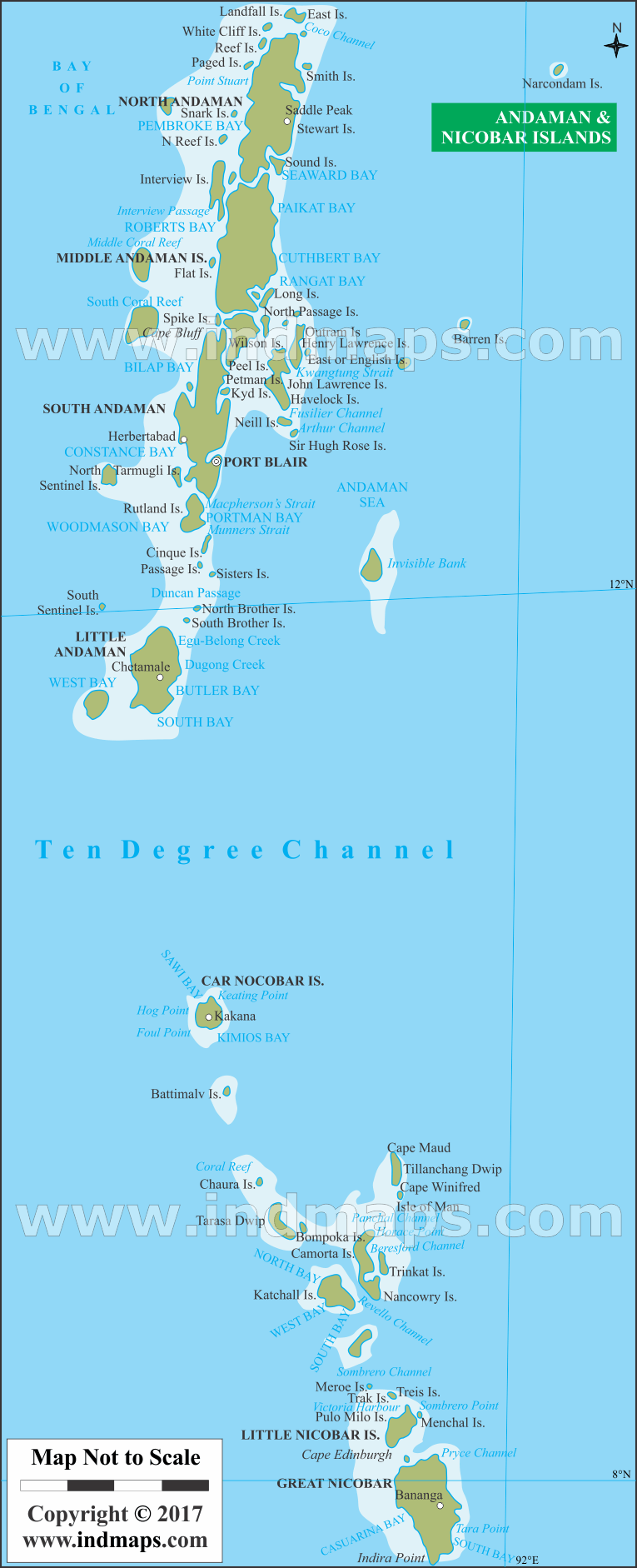
Andaman and Nicobar Islands, a Union territory of India comprising 572 islands of which 37 are inhabited, are a group of islands at the juncture of the Bay of Bengal and the Andaman Sea.
List of Districts in Andhra Pradesh, India
| District | Abbreviation | Headquarters | Area(km.²) | Population |
|---|---|---|---|---|
| Adilabad | AD | Adilabad | 16,105 | 2,741,239 |
| Anantapur | AN | Anantapur | 19,130 | 4,081,148 |
| Chittoor | CH | Chittoor | 15,152 | 4,174,064 |
| Cuddapah | CU | Cuddapah | 15,359 | 2,882,469 |
| East Godavari | EG | Kakinada | 10,807 | 5,154,296 |
| Guntur | GU | Guntur | 11,391 | 4,887,813 |
| Hyderabad | HY | Hyderabad | 217 | 3,943,323 |
| Karimnagar | KA | Karimnagar | 11,823 | 3,776,269 |
| Khammam | KH | Khammam | 16,029 | 2,797,370 |
| Krishna | KR | Machilipatnam | 8,727 | 4,517,398 |
| Kurnool | KU | Kurnool | 17,658 | 4,053,463 |
| Mahbubnagar | MA | Mahbubnagar | 18,432 | 4,053,028 |
| Medak | ME | Sangareddi | 9,699 | 3,033,288 |
| Nalgonda | NA | Nalgonda | 14,240 | 3,488,809 |
| Nellore | NE | Nellore | 13,076 | 2,963,557 |
| Nizamabad | NI | Nizamabad | 7,956 | 2,551,335 |
| Prakasam | PR | Ongole | 17,626 | 3,397,448 |
| Rangareddi | RA | Hyderabad | 7,493 | 5,296,741 |
| Srikakulam | SR | Srikakulam | 5,837 | 2,703,114 |
| Vishakhapatnam | VS | Vishakhapatnam | 11,161 | 4,290,589 |
| Vizianagaram | VZ | Vizianagaram | 6,539 | 2,344,474 |
| Warangal | WA | Warangal | 12,846 | 3,512,576 |
| West Godavari | WG | Eluru | 7,742 | 3,936,966 |
India States Map
List of Districts in India by States
- Andaman and Nicobar Islands (UT) Districts
- Andhra Pradesh Districts
- Arunachal Pradesh Districts
- Assam Districts
- Bihar Districts
- Chandigarh (UT) Districts
- Chhattisgarh Districts
- Dadra and Nagar Haveli (UT) Districts
- Daman and Diu (UT) Districts
- Delhi (UT) Districts
- Goa Districts
- Gujarat Districts
- Haryana Districts
- Himachal Pradesh Districts
- Jammu and Kashmir Districts
- Jharkhand Districts
- Karnataka Districts
- Kerala Districts
- Lakshadweep (UT) Districts
- Madhya Pradesh Districts
- Maharashtra Districts
- Manipur Districts
- Meghalaya Districts
- Mizoram Districts
- Nagaland Districts
- Odisha Districts
- Puducherry (UT) Districts
- Punjab Districts
- Rajasthan Districts
- Sikkim Districts
- Tamil Nadu Districts
- Tripura Districts
- Uttarakhand Districts
- Uttar Pradesh Districts
- West Bengal Districts