Written and Fact-checked by Whereig Editors | Updated On: May 01, 2026 | 23:55 ET
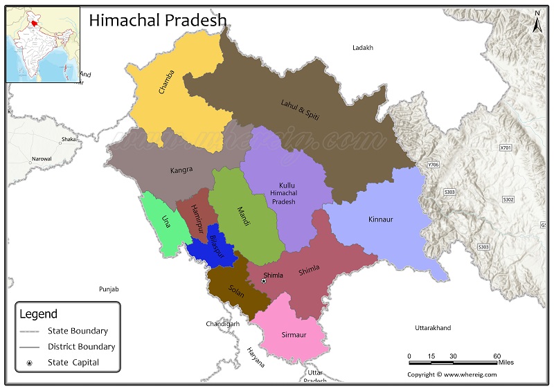
Himachal Pradesh divided into 12 districts. Explore Himachal Pradesh District Map, depicts all district boundary, state capital and neighbouring states, along with get information on Himachal Pradesh district headquarter, population, and area.
Map of Himachal Pradesh Districts
| Where is India | Cities in India | Where is Mumbai |
| Himachal Pradesh Map | Where is New Delhi | India Google Map |
| Airports in India | Where is Bangalore | Where is Hyderabad |
About Districts of Himachal Pradesh
Himachal Pradesh is a state located in Northern part of Inida. It is the 18th-largest state by area covering an area of 55,673 square km, with population of 6,864,602 inhabitants. It is bordered by the Jammu and Kashmir and Ladakh to the north, Haryana to the southwest, Punjab to the west, Uttarakhand to the southeast and Uttar Pradesh to the South. The state of Himachal Pradesh is divided into 12 districts. Shimla is the capital of Himachal Pradesh.
List of Districts in Himachal Pradesh
| District | Abbreviation | Headquarters | Area(km.²) | Population |
|---|---|---|---|---|
| Bilaspur | BI | Bilaspur | 1,167 | 381,956 |
| Chamba | CH | Chamba | 6,528 | 519,080 |
| Hamirpur | HA | Hamirpur | 1,118 | 454,768 |
| Kangra | KA | Dharamasala | 5,739 | 1,510,075 |
| Kinnaur | KI | Reckong Peo | 6,401 | 84,121 |
| Kulu | KU | Kulu | 5,503 | 437,903 |
| Lahaul and Spiti | LS | Keylong | 13,835 | 31,564 |
| Mandi | MA | Mandi | 3,950 | 999,777 |
| Shimla | SH | Shimla | 5,131 | 814,010 |
| Sirmaur | SI | Nahan | 2,825 | 529,855 |
| Solan | SO | Solan | 1,936 | 580,320 |
| Una | UN | Una | 1,540 | 521,173 |
Himachal Pradesh Districts Facts
| Name of State | Himachal Pradesh |
| Continent | Asia |
| Country | India |
| Region | Northern |
| Capital | Shimla |
| Coordinates | 31.1048° N, 77.1734° E |
| Number of Districts | 12 |
| Number of sub-districts | Tehsil - 109 |
| No. of Villages as of 2001 | 19,831 |
| Population | 6,864,602 |
| Area (km2) | 55,673 |
| Official Languages | Hindi, Sanskrit |
| Time Zone | IST (UTC+05:30) |
| Airport | Kangra Airport (Gaggal near Kangra), Shimla Airport (Shimla), Kullu-Manali Airport (Bhuntar) |
- Andaman and Nicobar Map
- Andhra Pradesh Map
- Arunachal Pradesh Map
- Assam Map
- Bihar Map
- Chandigarh Map
- Chhattisgarh Map
- Delhi Map
- Goa Map
- Gujarat Map
- Haryana Map
- Himachal Pradesh Map
- Jammu and Kashmir Map
- Jharkhand Map
- Karnataka Map
- Kerala Map
- Madhya Pradesh Map
- Maharashtra Map
- Manipur Map
- Meghalaya Map
- Mizoram Map
- Nagaland Map
- Odisha Map
- Punjab Map
- Rajasthan Map
- Sikkim Map
- Tamil Nadu Map
- Tripura Map
- Uttarakhand Map
- Uttar Pradesh Map
- West Bengal Map
- Andaman and Nicobar Islands District Map
- Andhra Pradesh District Map
- Arunachal Pradesh District Map
- Assam District Map
- Bihar District Map
- Chandigarh District Map
- Chhattisgarh District Map
- Dadra and Nagar Haveli District Map
- Daman and Diu District Map
- Delhi District Map
- Goa District Map
- Gujarat District Map
- Haryana District Map
- Himachal Pradesh District Map
- Jammu and Kashmir District Map
- Jharkhand District Map
- Karnataka District Map
- Kerala District Map
- Ladakh District Map
- Lakshadweep District Map
- Madhya Pradesh District Map
- Maharashtra District Map
- Manipur District Map
- Meghalaya District Map
- Mizoram District Map
- Nagaland District Map
- Odisha District Map
- Puducherry District Map
- Punjab District Map
- Rajasthan District Map
- Sikkim District Map
- Tamil Nadu District Map
- Telangana District Map
- Tripura District Map
- Uttar Pradesh District Map
- Uttarakhand District Map
- West Bengal District Map
- Where is Agra
- Where is Ahmadabad
- Where is Ahmadnagar
- Where is Ajmer
- Where is Akola
- Where is Aligarh
- Where is Allahabad
- Where is Amravati
- Where is Amritsar
- Where is Asansol
- Where is Aurangabad
- Where is Bareilly
- Where is Belgaum
- Where is Benares
- Where is Bengaluru
- Where is Bhatpara
- Where is Bhavnagar
- Where is Bhilai
- Where is Bhiwandi
- Where is Bhopal
- Where is Bhubaneswar
- Where is Bikaner
- Where is Bokaro
- Where is Calcutta
- Where is Calicut
- Where is Chandigarh
- Where is Chennai
- Where is Cochin
- Where is Coimbatore
- Where is Cuttack
- Where is Dehra Dun
- Where is Durgapur
- Where is Faridabad
- Where is Gaya
- Where is Ghaziabad
- Where is Gorakhpur
- Where is Gulbarga
- Where is Guntur
- Where is Guwahati
- Where is Gwalior
- Where is Haora
- Where is Hubli
- Where is Hyderabad
- Where is Indore
- Where is Joshimath
- Where is Jabalpur
- Where is Jaipur
- Where is Jalandhar
- Where is Jalgaon
- Where is Jammu
- Where is Jamnagar
- Where is Jamshedpur
- Where is Jhansi
- Where is Jodhpur
- Where is Kalyan
- Where is Kanpur
- Where is Kolhapur
- Where is Korba
- Where is Kota
- Where is Lucknow
- Where is Ludhiana
- Where is Madurai
- Where is Malegaon
- Where is Mangalore
- Where is Meerut
- Where is Moradabad
- Where is Mysore
- Where is Nagpur
- Where is Nangi
- Where is Nasik
- Where is Nellore
- Where is Panihati
- Where is Patna
- Where is Pimpri
- Where is Pune
- Where is Quilon
- Where is Raipur
- Where is Rajkot
- Where is Ranchi
- Where is Rourkela
- Where is Saharanpur
- Where is Salem
- Where is Shiliguri
- Where is Solapur
- Where is Srinagar
- Where is Surat
- Where is Teni
- Where is Thane
- Where is Thiruvananthapuram
- Where is Tiruchchirappalli
- Where is Tirunelveli
- Where is Tiruppur
- Where is Udaipur
- Where is Ujjain
- Where is Ulhasnagar
- Where is Vadodara
- Where is Vijayawada
- Where is Vishakhapatnam
- Where is Warangal