Written and Fact-checked by Whereig Editors | Updated On: May 01, 2026 | 23:55 ET
Uttar Pradesh is a state in northern India. it is the most populous state in India, it covers 243,290 square kilometres (93,933 sq mi), equal to 7.34% of the total area of India. The state is bordered by Rajasthan to the west, Haryana, Himachal Pradesh and Delhi to the northwest, Uttarakhand and Nepal country to the north, Bihar to the east, Madhya Pradesh to the south, and touches the states of Jharkhand and Chhattisgarh to the southeast. The state is divided into 18 divisions and 75 districts, with the state capital being Lucknow, and Allahabad serving as the judicial capital.
As of up.gov.in tere are 13 Municipal corporations, 226 municipal boards, 59163 gram sabhas, 822 development blocks, 97941 populated villages, 180000 post offices and 2885 telephone exchanges.
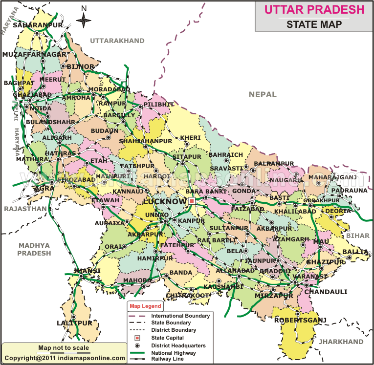
Map of Uttar Pradesh
 Map Sourse/ partner - indiamapsonline.com
About Map - Uttar Pradesh map showing state boundary, district boundary, roads, national highways, rail network & state capital.
| Uttar Pradesh District Map | Where is New Delhi | India Google Map |
| Where is India | Cities in India | Where is Mumbai |
| Airports in India | Where is Bangalore | Where is Hyderabad |
About Uttar Pradesh Map
Uttar Pradesh is one of the states of India, which is located northern part of the country. Uttar Pradesh is commonly called as UP. Here is the state map of Uttar Pradesh; one can explore more about the state with the help of the Map provided on this page. Uttar Pradesh Map depicts all districts, state capital and neighbouring states, district boundary, roads, national highways, rail network & state capital.
About Uttar Pradesh
Uttar Pradesh is one of the biggest states of India. There are more than 200 million people in the state. It is the fourth largest state in India. Before 1950, the state was called as United Provinces. It was in fact the successor of United Provinces. After India became a republic nation, the state was given its present name Uttar Pradesh. The capital of Uttar Pradesh is Lucknow. Uttar Pradesh shares the borders with Uttarakhand and the country Nepal to the north, Bihar is to the east, Jharkhand and Chhattisgarh to the southeast and Madhya Pradesh to the south, the states of Rajasthan, Haryana and the capital of India Delhi to the west. The judicial capital of the state is Allahabad. In the year 2000, a new state was created from some parts of Uttar Pradesh. Then it was named as Uttaranchal, later renamed as Uttarakhand.
About Districts of Uttar Pradesh
For the ease of administration, Uttar Pradesh is further divided into districts. Districts of Uttar Pradesh are 75 in number. These 75 districts of Uttar Pradesh are grouped as 18 divisions. A District Collector or District Magistrate administers each district. Among the districts of Uttar Pradesh, the largest district by area is Lakhimpur Kheri. Lakhimpur Kheri is a part of Lucknow division. Lakhimpur is on the border of Nepal. Bhadohi district is the smallest district of Uttar Pradesh. It is the smallest district by area. The best district of Uttar Pradesh is Varanasi. Allahabad has the highest population of the state in it. In the district of Allahabad, around 5,954,391 people are there. The second place goes to Moradabad, which is another district of Uttar Pradesh, has the population of 4.772,006. The district, which is the least populated district in Uttar Pradesh, is Mahoba with 875,958.
Uttar Pradesh State Information & Facts
| Name of State | Uttar Pradesh |
| Abbreviation | UP |
| Continent | Asia |
| Country | India |
| Region | Northern |
| Capital | Lucknow |
| Largest city | Kanpur |
| UP Regions | Awadh, Bagelkhand, Bhojpur-Purvanchal, Braj, Bundelkhand, Kannauj, and Rohilkhand |
| Coordinates | 26.8467° N, 80.9462° E |
| Formed On | 26 January 1950 |
| Number of districts | 75 |
| Number of sub-districts | Tehsil - 350 |
| No. of Villages as of 2001 | 107,440 |
| Population | 199,812,341 |
| Density (km2) | 829 |
| Area (km2) | 240,928 |
| UN/LOCODE | IN-UP |
| Vehicle registration | UP XX—XXXX |
| UP Governor | Anandiben Patel |
| UP Chief Minister | Yogi Adityanath |
| UP Deputy Chief Ministers | Keshav Prasad Maurya and Dinesh Sharma |
| Loksabha Seat | 80 |
| Assembly Seat | 403 |
| Rajya Sabha Seat | 31 |
| Official Languages | Hindi, Urdu |
| Time Zone | IST (UTC+05:30) |
| Literacy Rate (%) | 73 |
| Sex Ratio (per 1000 Males) | 987 |
| Human Development Index - HDI (2019) | 0.596 |
| Highest Point | Amsot Peak [Height - 957(m) & 3140(ft)] |
| Unemployment rate (%) As of May 2021) | 5 |
| Airport | Lal Bahadur Shastri International Airport (Varanasi), Chaudhary Charan Singh International Airport (Lucknow), Maryada Purushottam Shriram International Airport (Ayodhya) |
75 Districts in Uttar Pradesh
| S.N | District | Abbreviation | Headquarters | Division | Population | Area (Sq KM) | Density (/km) |
|---|---|---|---|---|---|---|---|
| 1 | Agra | AG | Agra | Agra | 4,418,800 | 4,027 | 1532 |
| 2 | Aligarh | AL | Aligarh | Aligarh | 3,690,388 | 3,747 | 798 |
| 3 | Allahabad | AH | Allahabad | Allahabad | 5,959,798 | 5,482 | 1087 |
| 4 | Ambedkar Nagar | AN | Akbarpur | Faizabad | 2,025,376 | 2,372 | 854 |
| 5 | Amethi | AM | Gauriganj | Faizabad | 2,549,935 | 3,315 | 769 |
| 6 | Amroha | JP | Amroha | Moradabad | 1,499,193 | 2,321 | 646 |
| 7 | Auraiya | AU | Auraiya | Kanpur | 1,179,496 | 2,051 | 575 |
| 8 | Azamgarh | AZ | Azamgarh | Azamgarh | 3,950,808 | 4,234 | 933 |
| 9 | Badaun | BD | Badaun | Bareilly | 3,069,245 | 5,168 | 594 |
| 10 | Bagpat | BG | Baghpat | Meerut | 1,163,991 | 1,389 | 838 |
| 11 | Bahraich | BH | Bahraich | Devipatan | 2,384,239 | 5,745 | 415 |
| 12 | Ballia | BL | Ballia | Azamgarh | 2,752,412 | 2,981 | 923 |
| 13 | Balrampur | BP | Balrampur | Devipatan | 1,684,567 | 2,925 | 576 |
| 14 | Banda | BN | Banda | Chitrakoot | 1,500,253 | 4,413 | 340 |
| 15 | Barabanki | BB | Barabanki | Faizabad | 2,673,394 | 3,825 | 699 |
| 16 | Bareilly | BR | Bareilly | Bareilly | 3,598,701 | 4,120 | 873 |
| 17 | Basti | BS | Basti | Basti | 2,068,922 | 3,034 | 682 |
| 18 | Bijnor | BI | Bijnor | Moradabad | 3,130,586 | 4,561 | 686 |
| 19 | Bulandshahr | BU | Bulandshahr | Meerut | 2,923,290 | 3,719 | 786 |
| 20 | Chandauli | CD | Chandauli | Varanasi | 1,639,777 | 2,554 | 642 |
| 21 | Chitrakoot | CT | Chitrakoot | Chitrakoot | 800,592 | 3,202 | 250 |
| 22 | Deoria | DE | Deoria | Gorakhpur | 2,730,376 | 2,535 | 1,077 |
| 23 | Etah | ET | Etah | Aligarh | 2,788,274 | 4,446 | 627 |
| 24 | Etawah | EW | Etawah | Kanpur | 1,340,031 | 2,287 | 586 |
| 25 | Faizabad | FZ | Faizabad | Faizabad | 2,087,914 | 2,765 | 755 |
| 26 | Farrukhabad | FR | Fatehgarh | Kanpur | 1,577,237 | 2,279 | 692 |
| 27 | Fatehpur | FT | Fatehpur | Allahabad | 2,305,847 | 4,152 | 555 |
| 28 | Firozabad | FI | Firozabad | Agra | 2,045,737 | 2,361 | 866 |
| 29 | Gautam Buddha Nagar | GB | Greater Noida | Meerut | 1,191,263 | 1,269 | 939 |
| 30 | Ghaziabad | GZ | Ghaziabad | Meerut | 3,289,540 | 1,956 | 1,682 |
| 31 | Ghazipur | GP | Ghazipur | Varanasi | 3,049,337 | 3,377 | 903 |
| 32 | Gonda | GN | Gonda | Devipatan | 2,765,754 | 4,425 | 625 |
| 33 | Gorakhpur | GR | Gorakhpur | Gorakhpur | 3,784,720 | 3,325 | 1,138 |
| 34 | Hamirpur | HM | Hamirpur | Chitrakoot | 1,042,374 | 4,325 | 241 |
| 35 | Hapur | HA | Hapur | Meerut | 1,338,211 | 660 | 2028 |
| 36 | Hardoi | HR | Hardoi | Lucknow | 3,397,414 | 5,986 | 568 |
| 37 | Hathras | HT | Hathras | Aligarh | 1,333,372 | 1,752 | 761 |
| 38 | Jalaun | JL | Orai | Jhansi | 1,454,452 | 4,565 | 319 |
| 39 | Jaunpur | JU | Jaunpur | Varanasi | 3,911,305 | 4,038 | 969 |
| 40 | Jhansi | JH | Jhansi | Jhansi | 1,746,715 | 5,024 | 348 |
| 41 | Kannauj | KJ | Kannauj | Kanpur | 1,385,227 | 1,993 | 695 |
| 42 | Kanpur Dehat | KD | Akbarpur | Kanpur | 1,584,037 | 3,143 | 504 |
| 43 | Kanpur Nagar | KN | Kanpur | Kanpur | 4,137,489 | 3,029 | 1,366 |
| 44 | Kasganj | KG | Kasganj | Aligarh | 1,438,156 | 1993 | 722 |
| 45 | Kaushambi | KS | Manjhanpur | Allahabad | 1,294,937 | 1,837 | 705 |
| 46 | Kushinagar | KU | Padarauna | Gorakhpur | 2,891,933 | 2,909 | 994 |
| 47 | Lakhimpur Kheri | LK | Kheri | Lucknow | 3,200,137 | 7,680 | 417 |
| 48 | Lalitpur | LA | Lalitpur | Jhansi | 977,447 | 5,039 | 194 |
| 49 | Lucknow | LU | Lucknow | Lucknow | 3,681,416 | 2,528 | 1,456 |
| 50 | Maharajganj | MG | Maharajganj | Gorakhpur | 2,167,041 | 2,948 | 735 |
| 51 | Mahoba | MH | Mahoba | Chitrakoot | 708,831 | 2,847 | 249 |
| 52 | Mainpuri | MP | Mainpuri | Agra | 1,592,875 | 2,760 | 577 |
| 53 | Mathura | MT | Mathura | Agra | 2,069,578 | 3,333 | 621 |
| 54 | Mau | MB | Mau | Azamgarh | 1,849,294 | 1,713 | 1,080 |
| 55 | Meerut | ME | Meerut | Meerut | 3,001,636 | 2,522 | 1,190 |
| 56 | Mirzapur | MI | Mirzapur | Mirzapur | 2,114,852 | 4,522 | 468 |
| 57 | Moradabad | MO | Moradabad | Moradabad | 3,749,630 | 3,648 | 1,028 |
| 58 | Muzaffarnagar | MU | Muzaffarnagar | Saharanpur | 3,541,952 | 2945 | 884 |
| 59 | Pilibhit | PI | Pilibhit | Bareilly | 1,643,788 | 3,499 | 470 |
| 60 | Pratapgarh | PR | Pratapgarh | Allahabad | 2,727,156 | 3,717 | 734 |
| 61 | Rae Bareli | RB | Rae Bareli | Lucknow | 2,872,204 | 4,609 | 623 |
| 62 | Rampur | RA | Rampur | Moradabad | 1,922,450 | 2,367 | 812 |
| 63 | Saharanpur | SA | Saharanpur | Saharanpur | 2,848,152 | 3,860 | 772 |
| 64 | Sant Kabir Nagar | SK | Khalilabad | Basti | 1,714,300 | 1,659.15 | 1000 |
| 65 | Sant Ravidas Nagar | SR | Gyanpur | Mirzapur | 1,352,056 | 960 | 1,408 |
| 66 | Sambhal | SM | Sambhal | Moradabad | 2,217,020 | 2452.3 | 890 |
| 67 | Shahjahanpur | SJ | Shahjahanpur | Bareilly | 2,549,458 | 4,575 | 557 |
| 68 | Shamli | SH | Shamli | Saharanpur | 1,377,840 | 1,054 | 928 |
| 69 | Shravasti | SV | Shravasti | Devipatan | 1,175,428 | 1,126 | 1,044 |
| 70 | Siddharthnagar | SN | Siddharthnagar | Basti | 2,038,598 | 2,751 | 741 |
| 71 | Sitapur | SI | Sitapur | Lucknow | 3,616,510 | 5,743 | 630 |
| 72 | Sonbhadra | SO | Robertsganj | Mirzapur | 1,862,612 | 6,788 | 270 |
| 73 | Sultanpur | SU | Sultanpur | Faizabad | 3,190,926 | 4,436 | 719 |
| 74 | Unnao | UN | Unnao | Lucknow | 2,700,426 | 4,558 | 592 |
| 75 | Varanasi (Kashi) | VA | Varanasi | Varanasi | 3,147,927 | 1,578 | 1,995 |
- Andaman and Nicobar Map
- Andhra Pradesh Map
- Arunachal Pradesh Map
- Assam Map
- Bihar Map
- Chandigarh Map
- Chhattisgarh Map
- Delhi Map
- Goa Map
- Gujarat Map
- Haryana Map
- Himachal Pradesh Map
- Jammu and Kashmir Map
- Jharkhand Map
- Karnataka Map
- Kerala Map
- Madhya Pradesh Map
- Maharashtra Map
- Manipur Map
- Meghalaya Map
- Mizoram Map
- Nagaland Map
- Odisha Map
- Punjab Map
- Rajasthan Map
- Sikkim Map
- Tamil Nadu Map
- Tripura Map
- Uttarakhand Map
- Uttar Pradesh Map
- West Bengal Map
- Andaman and Nicobar Districts
- Andhra Pradesh District Map
- Arunachal Pradesh District Map
- Assam District Map
- Bihar District Map
- Chandigarh District Map
- Chhattisgarh District Map
- Dadra and Nagar Haveli Districts
- Daman and Diu District Map
- Delhi District Map
- Goa District Map
- Gujarat District Map
- Haryana District Map
- Himachal Pradesh District Map
- Jammu and Kashmir District Map
- Jharkhand District Map
- Karnataka District Map
- Kerala District Map
- Ladakh District Map
- Lakshadweep District Map
- Madhya Pradesh District Map
- Maharashtra District Map
- Manipur District Map
- Meghalaya District Map
- Mizoram District Map
- Nagaland District Map
- Odisha District Map
- Puducherry District Map
- Punjab District Map
- Rajasthan District Map
- Sikkim District Map
- Tamil Nadu District Map
- Telangana District Map
- Tripura District Map
- Uttar Pradesh District Map
- Uttarakhand District Map
- West Bengal District Map
- Where is Agra
- Where is Ahmadabad
- Where is Ahmadnagar
- Where is Ajmer
- Where is Akola
- Where is Aligarh
- Where is Allahabad
- Where is Amravati
- Where is Amritsar
- Where is Asansol
- Where is Aurangabad
- Where is Bareilly
- Where is Belgaum
- Where is Benares
- Where is Bengaluru
- Where is Bhatpara
- Where is Bhavnagar
- Where is Bhilai
- Where is Bhiwandi
- Where is Bhopal
- Where is Bhubaneswar
- Where is Bikaner
- Where is Bokaro
- Where is Calcutta
- Where is Calicut
- Where is Chandigarh
- Where is Chennai
- Where is Cochin
- Where is Coimbatore
- Where is Cuttack
- Where is Dehra Dun
- Where is Durgapur
- Where is Faridabad
- Where is Gaya
- Where is Ghaziabad
- Where is Gorakhpur
- Where is Gulbarga
- Where is Guntur
- Where is Guwahati
- Where is Gwalior
- Where is Haora
- Where is Hubli
- Where is Hyderabad
- Where is Indore
- Where is Joshimath
- Where is Jabalpur
- Where is Jaipur
- Where is Jalandhar
- Where is Jalgaon
- Where is Jammu
- Where is Jamnagar
- Where is Jamshedpur
- Where is Jhansi
- Where is Jodhpur
- Where is Kalyan
- Where is Kanpur
- Where is Kolhapur
- Where is Korba
- Where is Kota
- Where is Lucknow
- Where is Ludhiana
- Where is Madurai
- Where is Malegaon
- Where is Mangalore
- Where is Meerut
- Where is Moradabad
- Where is Mysore
- Where is Nagpur
- Where is Nangi
- Where is Nasik
- Where is Nellore
- Where is Panihati
- Where is Patna
- Where is Pimpri
- Where is Pune
- Where is Quilon
- Where is Raipur
- Where is Rajkot
- Where is Ranchi
- Where is Rourkela
- Where is Saharanpur
- Where is Salem
- Where is Shiliguri
- Where is Solapur
- Where is Srinagar
- Where is Surat
- Where is Teni
- Where is Thane
- Where is Thiruvananthapuram
- Where is Tiruchchirappalli
- Where is Tirunelveli
- Where is Tiruppur
- Where is Udaipur
- Where is Ujjain
- Where is Ulhasnagar
- Where is Vadodara
- Where is Vijayawada
- Where is Vishakhapatnam
- Where is Warangal