Written and Fact-checked by Whereig Editors | Updated On: May 01, 2026 | 23:55 ET
Chandigarh is a city, district and union territory in India that serves as the capital of the two neighbouring states of Punjab and Haryana.
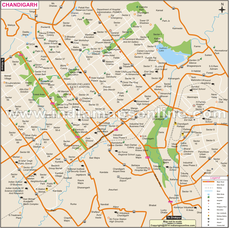
Map of Chandigarh
 Map Sourse/ partner - indiamapsonline.com
About Map - Chandigarh map showing state boundary, district boundary, roads, national highways, rail network & state capital.
| Chandigarh District Map | Where is New Delhi | India Google Map |
| Where is India | Cities in India | Where is Mumbai |
| Airports in India | Where is Bangalore | Where is Hyderabad |
About Chandigarh Map
Chandigarh is a city, district and union territory in India. Explore Chandigarh Map, depicts all districts, state capital and neighbouring states, district boundary, roads, national highways, rail network & state capital.
Chandigarh State Information & Facts
| Name of State | Chandigarh |
| Abbreviation | CH |
| Continent | Asia |
| Country | India |
| Region | Northern |
| Capital | Chandigarh |
| Coordinates | 30.7333° N, 76.7794° E |
| Founded On | 1 November 1966 |
| Number of districts | 1 |
| Number of sub-districts | Tehsil - 1 |
| No. of Villages as of 2001 | 24 |
| Population | 1,055,450 |
| Density (km2) | 9,258 |
| Area (km2) | 114 |
| Loksabha Seat | 1 |
| Assembly Seat | 0 |
| Rajya Sabha Seat | 0 |
| Official Languages | English |
| Time Zone | IST (UTC+05:30) |
| Literacy Rate | 86.43 |
| Sex Ratio | 861 |
| Human Development Index - HDI (2019) | 0.776 |
| Highest Point | Sivalik Hills [Height - 479(m) & 1572(ft)] |
| Unemployment rate (%) As of May 2021) | N/A |
| Airport | Jagdalpur Airport (Jagdalpur), Swami Vivekananda Airport (Raipur) |
List of Districts in Chandigarh State, India
| District | Abbreviation | Headquarters | Area(km.²) | Population |
|---|---|---|---|---|
| Chandigarh | CH | Chandigarh | 114 | 1,055,450 |
India States Map
- Andaman and Nicobar Map
- Andhra Pradesh Map
- Arunachal Pradesh Map
- Assam Map
- Bihar Map
- Chandigarh Map
- Chhattisgarh Map
- Delhi Map
- Goa Map
- Gujarat Map
- Haryana Map
- Himachal Pradesh Map
- Jammu and Kashmir Map
- Jharkhand Map
- Karnataka Map
- Kerala Map
- Madhya Pradesh Map
- Maharashtra Map
- Manipur Map
- Meghalaya Map
- Mizoram Map
- Nagaland Map
- Odisha Map
- Punjab Map
- Rajasthan Map
- Sikkim Map
- Tamil Nadu Map
- Tripura Map
- Uttarakhand Map
- Uttar Pradesh Map
- West Bengal Map
Districts in India by States
- Andaman and Nicobar Districts
- Andhra Pradesh District Map
- Arunachal Pradesh District Map
- Assam District Map
- Bihar District Map
- Chandigarh District Map
- Chhattisgarh District Map
- Dadra and Nagar Haveli Districts
- Daman and Diu District Map
- Delhi District Map
- Goa District Map
- Gujarat District Map
- Haryana District Map
- Himachal Pradesh District Map
- Jammu and Kashmir District Map
- Jharkhand District Map
- Karnataka District Map
- Kerala District Map
- Ladakh District Map
- Lakshadweep District Map
- Madhya Pradesh District Map
- Maharashtra District Map
- Manipur District Map
- Meghalaya District Map
- Mizoram District Map
- Nagaland District Map
- Odisha District Map
- Puducherry District Map
- Punjab District Map
- Rajasthan District Map
- Sikkim District Map
- Tamil Nadu District Map
- Telangana District Map
- Tripura District Map
- Uttar Pradesh District Map
- Uttarakhand District Map
- West Bengal District Map
Check Location Map of Indian Cities
- Where is Agra
- Where is Ahmadabad
- Where is Ahmadnagar
- Where is Ajmer
- Where is Akola
- Where is Aligarh
- Where is Allahabad
- Where is Amravati
- Where is Amritsar
- Where is Asansol
- Where is Aurangabad
- Where is Bareilly
- Where is Belgaum
- Where is Benares
- Where is Bengaluru
- Where is Bhatpara
- Where is Bhavnagar
- Where is Bhilai
- Where is Bhiwandi
- Where is Bhopal
- Where is Bhubaneswar
- Where is Bikaner
- Where is Bokaro
- Where is Calcutta
- Where is Calicut
- Where is Chandigarh
- Where is Chennai
- Where is Cochin
- Where is Coimbatore
- Where is Cuttack
- Where is Dehra Dun
- Where is Durgapur
- Where is Faridabad
- Where is Gaya
- Where is Ghaziabad
- Where is Gorakhpur
- Where is Gulbarga
- Where is Guntur
- Where is Guwahati
- Where is Gwalior
- Where is Haora
- Where is Hubli
- Where is Hyderabad
- Where is Indore
- Where is Joshimath
- Where is Jabalpur
- Where is Jaipur
- Where is Jalandhar
- Where is Jalgaon
- Where is Jammu
- Where is Jamnagar
- Where is Jamshedpur
- Where is Jhansi
- Where is Jodhpur
- Where is Kalyan
- Where is Kanpur
- Where is Kolhapur
- Where is Korba
- Where is Kota
- Where is Lucknow
- Where is Ludhiana
- Where is Madurai
- Where is Malegaon
- Where is Mangalore
- Where is Meerut
- Where is Moradabad
- Where is Mysore
- Where is Nagpur
- Where is Nangi
- Where is Nasik
- Where is Nellore
- Where is Panihati
- Where is Patna
- Where is Pimpri
- Where is Pune
- Where is Quilon
- Where is Raipur
- Where is Rajkot
- Where is Ranchi
- Where is Rourkela
- Where is Saharanpur
- Where is Salem
- Where is Shiliguri
- Where is Solapur
- Where is Srinagar
- Where is Surat
- Where is Teni
- Where is Thane
- Where is Thiruvananthapuram
- Where is Tiruchchirappalli
- Where is Tirunelveli
- Where is Tiruppur
- Where is Udaipur
- Where is Ujjain
- Where is Ulhasnagar
- Where is Vadodara
- Where is Vijayawada
- Where is Vishakhapatnam
- Where is Warangal