Written and Fact-checked by Whereig Editors | Updated On: May 01, 2026 | 23:56 ET
Google Map of India Satellite View shows the accurate geographic location, 28 states and 8 UTs, cities & towns, important places, rivers, roads, highways and more.
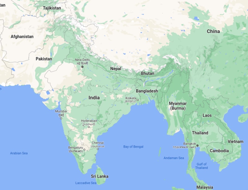
Google Map of India Satellite View
Map Sourse - Google.com/maps/India Google Map Image View
Google Map of India Satellite View
India, officially the Republic of India, is a country in South Asia. It is the seventh-largest country by area, It covers an area of 32, 87,263 sq. km and the second-most populous country in the World after China, India has a population of 1.32 billion people; and the most populous democracy in the world. It shares land borders with China, Bhutan, Nepal, Pakistan, Bangladesh and Myanmar while Sri Lanka shares only a maritime border.
India Information & Facts
| Continent | Asia |
| Region | South Asia |
| Capital | New Delhi |
| Largest city | Mumbai (city proper) Delhi (metropolitan area) |
| Coordinates | 21°N 78°E |
| India's Neighbouring countries | China, Bhutan, Nepal, Pakistan, Bangladesh, Myanmar and Sri Lanka (maritime border) |
| Official languages | Hindi, English |
| Native languages | 447+ languages |
| India States & UTs | 28 states and 8 union territories |
| Religion (2011) | 79.8% Hinduism, 14.2% Islam, 2.3% Christianity, 1.7% Sikhism, 0.7% Buddhism, 0.4% Jainism, 0.23% Unaffiliated, 0.65% Others |
| Demonym(s) | Indian |
| Membership | UN, Commonwealth of Nations, WTO, BRICS, SAARC, SCO, G4 nations, G20, Group of Five, G8+5 |
| Government | Federal parliamentary constitutional republic |
| Upper house | Rajya Sabha |
| Lower house | Lok Sabha |
| Independence Day | 15 August 1947 |
| Republic Day | 26 January 1950 |
| Area Total | 3,287,263 km2 (1,269,219 sq mi) (7th) |
| • Water (%) | 9.6 |
| Population (as of 2018) | 1,352,642,280 (2nd) |
| • Density | 413.3/km2 (1,070.4/sq mi) (19th) |
| GDP (PPP) 2021 estimate | $10.207 trillion (3rd) |
| • Per capita | $7,333 (122nd) |
| GDP (nominal) | 2021 estimate |
| GDP (nominal) Total (2021) | $3.050 trillion (6th) |
| • Per capita | $2,191 (145th) |
| Gini (2011) | 35.7 |
| HDI (2019) | 0.645 |
| Currency | Indian rupee (₹) (INR) |
| Time zone | UTC+05:30 (IST) |
| Calling code | + 91 |
| Highest point | Kangchenjunga - 8,586 m (28,169 ft) |
| Lowest point | Kuttanad: −2.2 m (−7.2 ft) |
| Longest river | Ganga - 2,525 km (1,569 mi) |
| Internet TLD | .in (others) |
India States Map
- Andaman and Nicobar Map
- Andhra Pradesh Map
- Arunachal Pradesh Map
- Assam Map
- Bihar Map
- Chandigarh Map
- Chhattisgarh Map
- Delhi Map
- Goa Map
- Gujarat Map
- Haryana Map
- Himachal Pradesh Map
- Jammu and Kashmir Map
- Jharkhand Map
- Karnataka Map
- Kerala Map
- Madhya Pradesh Map
- Maharashtra Map
- Manipur Map
- Meghalaya Map
- Mizoram Map
- Nagaland Map
- Odisha Map
- Punjab Map
- Rajasthan Map
- Sikkim Map
- Tamil Nadu Map
- Tripura Map
- Uttarakhand Map
- Uttar Pradesh Map
- West Bengal Map
Districts in India by States
- Andaman and Nicobar Districts
- Andhra Pradesh District Map
- Arunachal Pradesh District Map
- Assam District Map
- Bihar District Map
- Chandigarh District Map
- Chhattisgarh District Map
- Dadra and Nagar Haveli Districts
- Daman and Diu District Map
- Delhi District Map
- Goa District Map
- Gujarat District Map
- Haryana District Map
- Himachal Pradesh District Map
- Jammu and Kashmir District Map
- Jharkhand District Map
- Karnataka District Map
- Kerala District Map
- Ladakh District Map
- Lakshadweep District Map
- Madhya Pradesh District Map
- Maharashtra District Map
- Manipur District Map
- Meghalaya District Map
- Mizoram District Map
- Nagaland District Map
- Odisha District Map
- Puducherry District Map
- Punjab District Map
- Rajasthan District Map
- Sikkim District Map
- Tamil Nadu District Map
- Telangana District Map
- Tripura District Map
- Uttar Pradesh District Map
- Uttarakhand District Map
- West Bengal District Map
Check Location Map of Indian Cities
- Where is Agra
- Where is Ahmadabad
- Where is Ahmadnagar
- Where is Ajmer
- Where is Akola
- Where is Aligarh
- Where is Allahabad
- Where is Amravati
- Where is Amritsar
- Where is Asansol
- Where is Aurangabad
- Where is Bareilly
- Where is Belgaum
- Where is Benares
- Where is Bengaluru
- Where is Bhatpara
- Where is Bhavnagar
- Where is Bhilai
- Where is Bhiwandi
- Where is Bhopal
- Where is Bhubaneswar
- Where is Bikaner
- Where is Bokaro
- Where is Calcutta
- Where is Calicut
- Where is Chandigarh
- Where is Chennai
- Where is Cochin
- Where is Coimbatore
- Where is Cuttack
- Where is Dehra Dun
- Where is Durgapur
- Where is Faridabad
- Where is Gaya
- Where is Ghaziabad
- Where is Gorakhpur
- Where is Gulbarga
- Where is Guntur
- Where is Guwahati
- Where is Gwalior
- Where is Haora
- Where is Hubli
- Where is Hyderabad
- Where is Indore
- Where is Joshimath
- Where is Jabalpur
- Where is Jaipur
- Where is Jalandhar
- Where is Jalgaon
- Where is Jammu
- Where is Jamnagar
- Where is Jamshedpur
- Where is Jhansi
- Where is Jodhpur
- Where is Kalyan
- Where is Kanpur
- Where is Kolhapur
- Where is Korba
- Where is Kota
- Where is Lucknow
- Where is Ludhiana
- Where is Madurai
- Where is Malegaon
- Where is Mangalore
- Where is Meerut
- Where is Moradabad
- Where is Mysore
- Where is Nagpur
- Where is Nangi
- Where is Nasik
- Where is Nellore
- Where is Panihati
- Where is Patna
- Where is Pimpri
- Where is Pune
- Where is Quilon
- Where is Raipur
- Where is Rajkot
- Where is Ranchi
- Where is Rourkela
- Where is Saharanpur
- Where is Salem
- Where is Shiliguri
- Where is Solapur
- Where is Srinagar
- Where is Surat
- Where is Teni
- Where is Thane
- Where is Thiruvananthapuram
- Where is Tiruchchirappalli
- Where is Tirunelveli
- Where is Tiruppur
- Where is Udaipur
- Where is Ujjain
- Where is Ulhasnagar
- Where is Vadodara
- Where is Vijayawada
- Where is Vishakhapatnam
- Where is Warangal