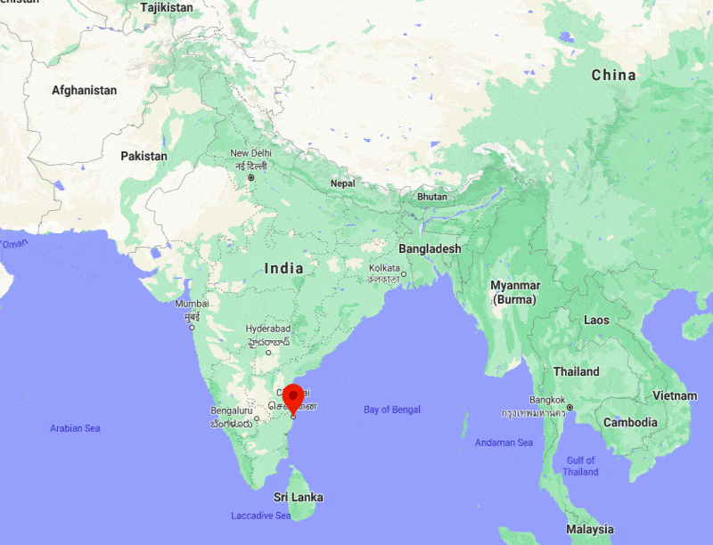
Where is Chennai Located, India?
Written and Fact-checked by Whereig Web Team | Updated On: November 09, 2025, 09:10 IST
Chennai is located on the south–eastern coast of India in the north–eastern part of Tamil Nadu. Chennai lies between 13°04′57.7″ North latitudes and 80°16′14.5° East longitudes. The city covers an area of about 1,189 km2 with a population of 12395000 people.
Chennai Location Map, Tamil Nadu, India

Where is Chennai Located?
Chennai is the capital of the Indian state of Tamil Nadu. Chennai is located on the south–eastern coast of India in the north–eastern part of Tamil Nadu, It is situated on the Coromandel Coast of the Bay of Bengal. Chennai lies between latitudes 13.0878385 and longitudes 80.2784729. The city's total area is 426 sq. km (164.5 sq mi). Its Distance from Pune to Delhi is 2,184 kilometres (1,357 mi), to Mumbai 1,337 kilometres (831 mi), and to Bangalore 345 kilometres (214 mi) by road. Chennai is the 6th most populous city in India, with an estimated population of 7,088,000 as of 2020.
Chennai City Facts
| Info | Datails |
|---|---|
| City Name | Chennai |
| Country | India |
| State | Tamil Nadu |
| District | Chennai |
| Coordinates | 13°04′57.7″N 80°16′14.5″E |
| Area | 1,189 km2 |
| Elevation | 7 m |
| Population | 12,395,000 |
| Time Zone | UTC+5:30 (IST) |
| Language | Tamil |
| Pincode(s) | 600001 |
| STD Code | 44 |
| Nearest Airport | Chennai International Airport |
| National Highway | Highway NH4,45 |
Places to Visit in Chennai
The top attractions to visit in Chennai are: Santhome Cathedral Basilica, Arulmigu Sri Parthasarathy,Arulmigu Vadapalani Murugan Temple, Marina Beach, Shree Sai Baba Temple,Chennai Rail Museum, Annai Velankanni Shrine, Mylapore, Guindy National Park,
- Where is Agra
- Where is Ahmadabad
- Where is Ahmadnagar
- Where is Ajmer
- Where is Akola
- Where is Aligarh
- Where is Allahabad
- Where is Amravati
- Where is Amritsar
- Where is Asansol
- Where is Aurangabad
- Where is Bareilly
- Where is Belgaum
- Where is Benares
- Where is Bengaluru
- Where is Bhatpara
- Where is Bhavnagar
- Where is Bhilai
- Where is Bhiwandi
- Where is Bhopal
- Where is Bhubaneswar
- Where is Bikaner
- Where is Bokaro
- Where is Calcutta
- Where is Calicut
- Where is Chandigarh
- Where is Chennai
- Where is Cochin
- Where is Coimbatore
- Where is Cuttack
- Where is Dehra Dun
- Where is Durgapur
- Where is Faridabad
- Where is Gaya
- Where is Ghaziabad
- Where is Gorakhpur
- Where is Gulbarga
- Where is Guntur
- Where is Guwahati
- Where is Gwalior
- Where is Haora
- Where is Hubli
- Where is Hyderabad
- Where is Indore
- Where is Joshimath
- Where is Jabalpur
- Where is Jaipur
- Where is Jalandhar
- Where is Jalgaon
- Where is Jammu
- Where is Jamnagar
- Where is Jamshedpur
- Where is Jhansi
- Where is Jodhpur
- Where is Kalyan
- Where is Kanpur
- Where is Kolhapur
- Where is Korba
- Where is Kota
- Where is Lucknow
- Where is Ludhiana
- Where is Madurai
- Where is Malegaon
- Where is Mangalore
- Where is Meerut
- Where is Moradabad
- Where is Mysore
- Where is Nagpur
- Where is Nangi
- Where is Nasik
- Where is Nellore
- Where is Panihati
- Where is Patna
- Where is Pimpri
- Where is Pune
- Where is Quilon
- Where is Raipur
- Where is Rajkot
- Where is Ranchi
- Where is Rourkela
- Where is Saharanpur
- Where is Salem
- Where is Shiliguri
- Where is Solapur
- Where is Srinagar
- Where is Surat
- Where is Teni
- Where is Thane
- Where is Thiruvananthapuram
- Where is Tiruchchirappalli
- Where is Tirunelveli
- Where is Tiruppur
- Where is Udaipur
- Where is Ujjain
- Where is Ulhasnagar
- Where is Vadodara
- Where is Vijayawada
- Where is Vishakhapatnam
- Where is Warangal
