Written and Fact-checked by Whereig Editors | Updated On: May 01, 2026 | 23:55 ET
Maharashtra is a state in the western peninsular region of India. It is the second-most populous state and third-largest state by area.
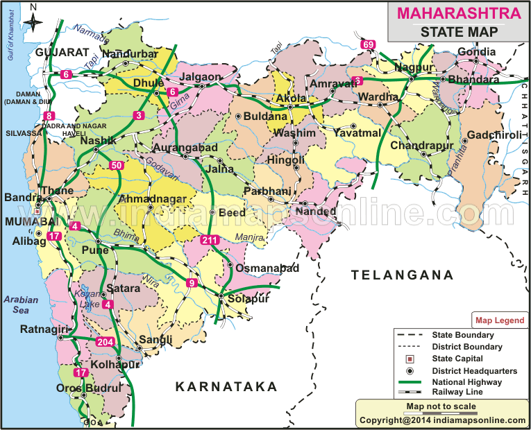
Map of Maharashtra
 Map Sourse/ partner - indiamapsonline.com
About Map - Maharashtra map showing state boundary, district boundary, roads, national highways, rail network & state capital.
| Maharashtra District Map | Where is New Delhi | India Google Map |
| Where is India | Cities in India | Where is Mumbai |
| Airports in India | Where is Bangalore | Where is Hyderabad |
Maharashtra Map
Maharashtra is financial capital of India and second largest state in terms of population. It is located in part western part of India. Here is the state map of Maharashtra and its districts and their borders. Check out more details about the districts of Maharashtra from this page. Maharashtra Map, depicts all districts, state capital and neighbouring states, district boundary, roads, national highways, rail network & state capital.
About Maharashtra
Maharashtra is one of the Indian states, which is situated in the western and central peninsular region of India. It occupies some portion of Deccan Plateau. Maharashtra is the third biggest state by area in India. The state is bordered by the Arabian Sea to the West, the Indian states of Karnataka and Goa to the south. Telangana is located to the southeast of the state and Chhattisgarh to the east, Gujarat and Madhya Pradesh to the north. Maharashtra is in second place in population as it is considered as second most populous state in India. The formation of the state happened in the year 1960. Maharashtra is Marathi speaking state because it is the home for Marathi people. Majority of people speak, Marathi. The capital city of the state is Mumbai. Mumbai is known as the commercial capital or financial capital of India. In fact, Mumbai has become one of the financial hubs of the world. There are two major rivers in the state. They are Krishna and Godavari. Maharashtra is the most developed state and industrialized state in India. The state has been playing a vital role in the country`s political and social life. The state has an extra edge in producing the agricultural and industrial goods. Maharashtra got fifteenth position in human development index.
The Districts of Maharashtra
The districts of Maharashtra are 36 in number. They are segregated into 6 revenue divisions viz Konkan, Pune, Nashik, Aurangabad, Arnravati and Nagpur. These districts are again bifurcated into 357 talukas. The largest district of Maharashtra is Ahmednagar by area of having 17048 square kilometers. The tiniest district of the state is Mumbai City District, which occupied the area of the state just in 36 square kilometers. Among all the districts of Maharashtra Thane is the highest populated district in the state. Pune stands in the second position in terms of having the second biggest district in population. The least populated district in the state is Sindhudurg. The richest district in the state is while Vidarbha has remained the poorest district.
Maharashtra follows parliamentary form of government with dual democratically elected houses. They are the Legislative Assembly and Legislative Council. The Legislative Assembly of Maharashtra consists of 288 members and they are elected for the term of 5 years. The Maharashtra Legislative Council has 78 members. The Chief Minister is the head of the government of Maharashtra. The Chief Minister along with the council of ministers exercises the executive powers. The constitutional and formal head of the state is the Governor. The President of India for the tenure of 5 Years appoints governor.
Maharashtra State Information & Facts
| Name of State | Maharashtra |
| Abbreviation | MH |
| Continent | Asia |
| Country | India |
| Region | Western |
| Capital | Mumbai |
| Coordinates | 19.7515° N, 75.7139° E |
| Formed On | 1 May 1960 |
| Number of districts | 36 |
| Number of sub-districts | Taluk - 353 |
| No. of Villages as of 2001 | 43,722 |
| Population | 112,374,333 |
| Density (km2) | 365 |
| Area (km2) | 307,713 |
| Loksabha Seat | 48 |
| Assembly Seat | 288 |
| Rajya Sabha Seat | 19 |
| Official Languages | Marathi |
| Time Zone | IST (UTC+05:30) |
| Literacy Rate (%) | 84.8 |
| Sex Ratio (per 1000 Males) | 972 |
| Human Development Index - HDI (2019) | 0.697 |
| Highest Point | Kalsubai [Height - 1646(m) & 5400(ft)] |
| Unemployment rate (%) As of May 2021) | 4.3 |
| Airport | Chhatrapati Shivaji Maharaja International Airport (Mumbai), Pune Airport (Pune), Dr. Babasaheb Ambedkar International Airport (Nagpur), Akola Airport (Akola), Aurangabad Airport (Aurangabad), Jalgaon Airport (Nashik), Chhatrapati Rajaram Maharaj Airport (Kolhapur), Gandhinagar Airport (Nashik), Solapur Airport (Solapur) |
List of Districts in Maharashtra State, India
| District | Abbreviation | Headquarters | Area(km.²) | Population |
|---|---|---|---|---|
| Ahmednagar | AH | Ahmednagar | 17,048 | 4,543,159 |
| Akola | AK | Akola | 5,429 | 1,813,906 |
| Amravati | AM | Amravati | 12,235 | 2,888,445 |
| Aurangabad | AU | Aurangabad | 10,107 | 3,701,282 |
| Bhandara | BH | Bhandara | 3,890 | 1,200,334 |
| Bid | BI | Bid | 10,693 | 2,585,049 |
| Buldhana | BU | Buldhana | 9,661 | 2,586,258 |
| Chandrapur | CH | Chandrapur | 11,443 | 2,204,307 |
| Dhule | DH | Dhule | 8,095 | 2,050,862 |
| Gadchiroli | GA | Gadchiroli | 14,412 | 1,072,942 |
| Gondiya | GO | Gondiya | 5,431 | 1,322,507 |
| Hingoli | HI | Hingoli | 4,526 | 1,177,345 |
| Jalgaon | JG | Jalgaon | 11,765 | 4,229,917 |
| Jalna | JN | Jalna | 7,718 | 1,959,046 |
| Kolhapur | KO | Kolhapur | 7,685 | 3,876,001 |
| Latur | LA | Latur | 7,157 | 2,454,196 |
| Mumbai City | MC | Mumbai City | 69 | 3,085,411 |
| Mumbai Suburban | MU | Bandra | 534 | 9,356,962 |
| Nagpur | NG | Nagpur | 9,892 | 4,653,570 |
| Nanded | ND | Nanded | 10,528 | 3,361,292 |
| Nandurbar | NB | Nandurbar | 5,055 | 1,648,295 |
| Nashik | NS | Nashik | 15,539 | 6,107,187 |
| Osmanabad | OS | Osmanabad | 7,569 | 1,657,576 |
| Parbhani | PA | Parbhani | 6,511 | 1,836,086 |
| Pune | PU | Pune | 15,643 | 9,429,408 |
| Raigarh | RG | Alibag | 7,152 | 2,634,200 |
| Ratnagiri | RT | Ratnagiri | 8,208 | 1,615,069 |
| Sangli | SN | Sangli | 8,572 | 2,822,143 |
| Satara | ST | Satara | 10,475 | 3,003,741 |
| Sindhudurg | SI | Oras | 5,207 | 849,651 |
| Solapur | SO | Solapur | 14,895 | 4,317,756 |
| Thane | TH | Thane | 9,558 | 11,060,148 |
| Wardha | WR | Wardha | 6,309 | 1,300,774 |
| Washim | WS | Washim | 5,155 | 1,197,160 |
| Yavatmal | YA | Yavatmal | 13,582 | 2,772,348 |
- Andaman and Nicobar Map
- Andhra Pradesh Map
- Arunachal Pradesh Map
- Assam Map
- Bihar Map
- Chandigarh Map
- Chhattisgarh Map
- Delhi Map
- Goa Map
- Gujarat Map
- Haryana Map
- Himachal Pradesh Map
- Jammu and Kashmir Map
- Jharkhand Map
- Karnataka Map
- Kerala Map
- Madhya Pradesh Map
- Maharashtra Map
- Manipur Map
- Meghalaya Map
- Mizoram Map
- Nagaland Map
- Odisha Map
- Punjab Map
- Rajasthan Map
- Sikkim Map
- Tamil Nadu Map
- Tripura Map
- Uttarakhand Map
- Uttar Pradesh Map
- West Bengal Map
- Andaman and Nicobar Districts
- Andhra Pradesh District Map
- Arunachal Pradesh District Map
- Assam District Map
- Bihar District Map
- Chandigarh District Map
- Chhattisgarh District Map
- Dadra and Nagar Haveli Districts
- Daman and Diu District Map
- Delhi District Map
- Goa District Map
- Gujarat District Map
- Haryana District Map
- Himachal Pradesh District Map
- Jammu and Kashmir District Map
- Jharkhand District Map
- Karnataka District Map
- Kerala District Map
- Ladakh District Map
- Lakshadweep District Map
- Madhya Pradesh District Map
- Maharashtra District Map
- Manipur District Map
- Meghalaya District Map
- Mizoram District Map
- Nagaland District Map
- Odisha District Map
- Puducherry District Map
- Punjab District Map
- Rajasthan District Map
- Sikkim District Map
- Tamil Nadu District Map
- Telangana District Map
- Tripura District Map
- Uttar Pradesh District Map
- Uttarakhand District Map
- West Bengal District Map
- Where is Agra
- Where is Ahmadabad
- Where is Ahmadnagar
- Where is Ajmer
- Where is Akola
- Where is Aligarh
- Where is Allahabad
- Where is Amravati
- Where is Amritsar
- Where is Asansol
- Where is Aurangabad
- Where is Bareilly
- Where is Belgaum
- Where is Benares
- Where is Bengaluru
- Where is Bhatpara
- Where is Bhavnagar
- Where is Bhilai
- Where is Bhiwandi
- Where is Bhopal
- Where is Bhubaneswar
- Where is Bikaner
- Where is Bokaro
- Where is Calcutta
- Where is Calicut
- Where is Chandigarh
- Where is Chennai
- Where is Cochin
- Where is Coimbatore
- Where is Cuttack
- Where is Dehra Dun
- Where is Durgapur
- Where is Faridabad
- Where is Gaya
- Where is Ghaziabad
- Where is Gorakhpur
- Where is Gulbarga
- Where is Guntur
- Where is Guwahati
- Where is Gwalior
- Where is Haora
- Where is Hubli
- Where is Hyderabad
- Where is Indore
- Where is Joshimath
- Where is Jabalpur
- Where is Jaipur
- Where is Jalandhar
- Where is Jalgaon
- Where is Jammu
- Where is Jamnagar
- Where is Jamshedpur
- Where is Jhansi
- Where is Jodhpur
- Where is Kalyan
- Where is Kanpur
- Where is Kolhapur
- Where is Korba
- Where is Kota
- Where is Lucknow
- Where is Ludhiana
- Where is Madurai
- Where is Malegaon
- Where is Mangalore
- Where is Meerut
- Where is Moradabad
- Where is Mysore
- Where is Nagpur
- Where is Nangi
- Where is Nasik
- Where is Nellore
- Where is Panihati
- Where is Patna
- Where is Pimpri
- Where is Pune
- Where is Quilon
- Where is Raipur
- Where is Rajkot
- Where is Ranchi
- Where is Rourkela
- Where is Saharanpur
- Where is Salem
- Where is Shiliguri
- Where is Solapur
- Where is Srinagar
- Where is Surat
- Where is Teni
- Where is Thane
- Where is Thiruvananthapuram
- Where is Tiruchchirappalli
- Where is Tirunelveli
- Where is Tiruppur
- Where is Udaipur
- Where is Ujjain
- Where is Ulhasnagar
- Where is Vadodara
- Where is Vijayawada
- Where is Vishakhapatnam
- Where is Warangal