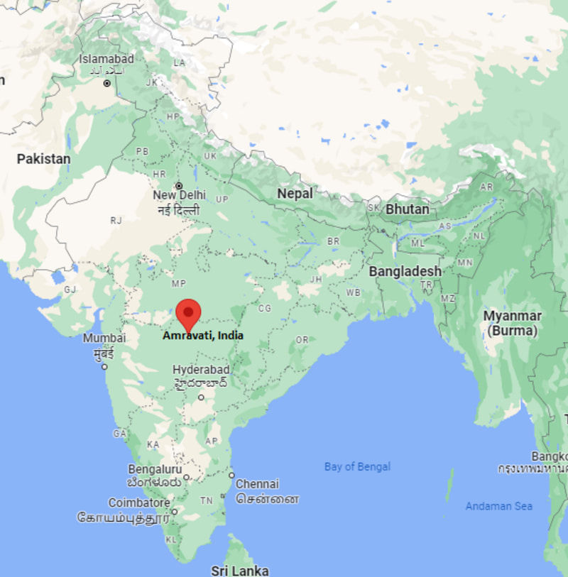
Where is Amravati Located, India?
Written and Fact-checked by Whereig Web Team | Updated On: November 09, 2025, 09:10 IST
Where is Amravati located? Amravati District is located due North East of Maharashtra state.. Check Amravati city facts, area, population, places to visit in Bhilai, Bhilai pin code, std code, and information about highways and nearest airport.
Location Map of Amravati, India

Where is Amravati Located?
Amravati District is located due North East of Maharashtra state.. Amravati lies between 20°55′33″ North latitudes and 77°45′53° East longitudes. The city covers an area of about 183.5 km2 with a population of 647601 people.
Amravati City Facts
| Info | Datails |
|---|---|
| City Name | Amravati |
| Country | India |
| State | Maharashtra |
| District | Amravati |
| Coordinates | 20°55′33″N 77°45′53″E |
| Area | 183.5 km2 |
| Elevation | 343 m |
| Population | 647,601 |
| Time Zone | UTC+5:30 (IST) |
| Language | Marathi |
| Pincode(s) | 444601 |
| STD Code | 721 |
| Nearest Airport | Dr. Panjabrao Deshmukh Airport Amravati |
| National Highway | Highway NH6 |
| Website | www.amravati.gov.in |
Places to Visit in Amravati
The top attractions to visit in Amravati are: Shri Ambadevi Temple, Amravati,Melghat Tiger Reserve,Jawahar Gate Fort, Chatri Talao.
Check Location Map of Indian Cities
- Where is Agra
- Where is Ahmadabad
- Where is Ahmadnagar
- Where is Ajmer
- Where is Akola
- Where is Aligarh
- Where is Allahabad
- Where is Amravati
- Where is Amritsar
- Where is Asansol
- Where is Aurangabad
- Where is Bareilly
- Where is Belgaum
- Where is Benares
- Where is Bengaluru
- Where is Bhatpara
- Where is Bhavnagar
- Where is Bhilai
- Where is Bhiwandi
- Where is Bhopal
- Where is Bhubaneswar
- Where is Bikaner
- Where is Bokaro
- Where is Calcutta
- Where is Calicut
- Where is Chandigarh
- Where is Chennai
- Where is Cochin
- Where is Coimbatore
- Where is Cuttack
- Where is Dehra Dun
- Where is Durgapur
- Where is Faridabad
- Where is Gaya
- Where is Ghaziabad
- Where is Gorakhpur
- Where is Gulbarga
- Where is Guntur
- Where is Guwahati
- Where is Gwalior
- Where is Haora
- Where is Hubli
- Where is Hyderabad
- Where is Indore
- Where is Joshimath
- Where is Jabalpur
- Where is Jaipur
- Where is Jalandhar
- Where is Jalgaon
- Where is Jammu
- Where is Jamnagar
- Where is Jamshedpur
- Where is Jhansi
- Where is Jodhpur
- Where is Kalyan
- Where is Kanpur
- Where is Kolhapur
- Where is Korba
- Where is Kota
- Where is Lucknow
- Where is Ludhiana
- Where is Madurai
- Where is Malegaon
- Where is Mangalore
- Where is Meerut
- Where is Moradabad
- Where is Mysore
- Where is Nagpur
- Where is Nangi
- Where is Nasik
- Where is Nellore
- Where is Panihati
- Where is Patna
- Where is Pimpri
- Where is Pune
- Where is Quilon
- Where is Raipur
- Where is Rajkot
- Where is Ranchi
- Where is Rourkela
- Where is Saharanpur
- Where is Salem
- Where is Shiliguri
- Where is Solapur
- Where is Srinagar
- Where is Surat
- Where is Teni
- Where is Thane
- Where is Thiruvananthapuram
- Where is Tiruchchirappalli
- Where is Tirunelveli
- Where is Tiruppur
- Where is Udaipur
- Where is Ujjain
- Where is Ulhasnagar
- Where is Vadodara
- Where is Vijayawada
- Where is Vishakhapatnam
- Where is Warangal
