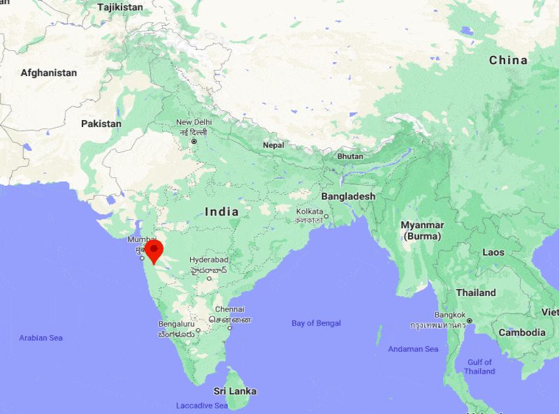
Where is Punea Located, India?
Written and Fact-checked by Whereig Web Team | Updated On: November 09, 2025, 09:10 IST
Pune is a city located in the state of Maharashtra in western India.. Pune lies between 18°31′13° North latitudes and 73°51′24° East longitudes. The city covers an area of about 7,290 km2 with a population of 3124458 people
Pune Location Map, Maharashtra, India

Where is Punea Located?
Pune is the second-largest metropolitan city in the Indian State of Maharashtra. Pune lies between latitudes 18.5195742 and longitudes 73.8553543. The city's total area is 15.642 sq. km. Its Distance from Pune to Delhi is 1,173 km (729 mi), to Bangalore 734 km (456 mi), 570 km (350 mi) to Hyderabad and 149 km (93 mi) to Mumbai. Pune is the 8th most populous city in India, with an estimated population of 7.4 million as of 2020..
Punea City Facts
| Info | Datails |
|---|---|
| City Name | Pune |
| Country | India |
| State | Maharashtra |
| District | Pune |
| Coordinates | 18°31′13″N 73°51′24″E |
| Area | 7,290 km2 |
| Elevation | 560 m |
| Population | 3,124,458 |
| Time Zone | UTC+5:30 (IST) |
| Language | Hindi |
| Pincode(s) | 411001 |
| STD Code | 20 |
| Nearest Airport | Pune International Airport (PNQ) |
| National Highway | Highway NH 48,NH65,NH60,NH27 |
| Website | pmc.gov.in |
Places to Visit in Punea
The top attractions to visit in Pune are: Shaniwar Wada,Aga Khan Palace,Shreemant Dagdusheth,Rajiv Gandhi Zoological Park,Sinhagad Fort,Mahadji Shinde Chhatri
- Where is Agra
- Where is Ahmadabad
- Where is Ahmadnagar
- Where is Ajmer
- Where is Akola
- Where is Aligarh
- Where is Allahabad
- Where is Amravati
- Where is Amritsar
- Where is Asansol
- Where is Aurangabad
- Where is Bareilly
- Where is Belgaum
- Where is Benares
- Where is Bengaluru
- Where is Bhatpara
- Where is Bhavnagar
- Where is Bhilai
- Where is Bhiwandi
- Where is Bhopal
- Where is Bhubaneswar
- Where is Bikaner
- Where is Bokaro
- Where is Calcutta
- Where is Calicut
- Where is Chandigarh
- Where is Chennai
- Where is Cochin
- Where is Coimbatore
- Where is Cuttack
- Where is Dehra Dun
- Where is Durgapur
- Where is Faridabad
- Where is Gaya
- Where is Ghaziabad
- Where is Gorakhpur
- Where is Gulbarga
- Where is Guntur
- Where is Guwahati
- Where is Gwalior
- Where is Haora
- Where is Hubli
- Where is Hyderabad
- Where is Indore
- Where is Joshimath
- Where is Jabalpur
- Where is Jaipur
- Where is Jalandhar
- Where is Jalgaon
- Where is Jammu
- Where is Jamnagar
- Where is Jamshedpur
- Where is Jhansi
- Where is Jodhpur
- Where is Kalyan
- Where is Kanpur
- Where is Kolhapur
- Where is Korba
- Where is Kota
- Where is Lucknow
- Where is Ludhiana
- Where is Madurai
- Where is Malegaon
- Where is Mangalore
- Where is Meerut
- Where is Moradabad
- Where is Mysore
- Where is Nagpur
- Where is Nangi
- Where is Nasik
- Where is Nellore
- Where is Panihati
- Where is Patna
- Where is Pimpri
- Where is Pune
- Where is Quilon
- Where is Raipur
- Where is Rajkot
- Where is Ranchi
- Where is Rourkela
- Where is Saharanpur
- Where is Salem
- Where is Shiliguri
- Where is Solapur
- Where is Srinagar
- Where is Surat
- Where is Teni
- Where is Thane
- Where is Thiruvananthapuram
- Where is Tiruchchirappalli
- Where is Tirunelveli
- Where is Tiruppur
- Where is Udaipur
- Where is Ujjain
- Where is Ulhasnagar
- Where is Vadodara
- Where is Vijayawada
- Where is Vishakhapatnam
- Where is Warangal
