Written and Fact-checked by Whereig Editors | Updated On: May 01, 2026 | 23:55 ET
Kerala is a state on the southwestern Malabar Coast of India. It is bordered by Karnataka to the north and northeast, Tamil Nadu to the east and south, and the Lakshadweep Sea to the west.
Map of Kerala
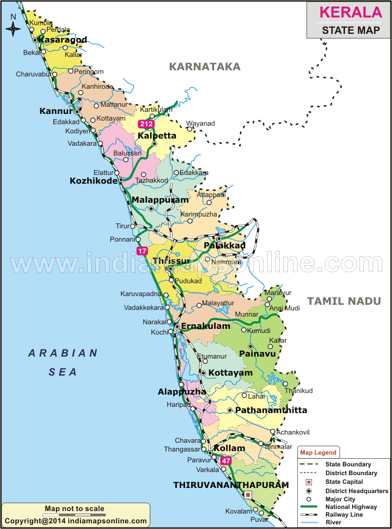 Map Sourse/ partner - indiamapsonline.com
About Map - Kerala map showing state boundary, district boundary, roads, national highways, rail network & state capital.
| Kerala District Map | Where is New Delhi | India Google Map |
| Where is India | Cities in India | Where is Mumbai |
| Airports in India | Where is Bangalore | Where is Hyderabad |
About Kerala Map
Kerala is located in southwestern part of India. It is one of the small states of India. It is known as God`s own country. Find out more details about Punjab and districts of the state and their borders on the map that is provided on this page. Kerala Map, depicts all districts, state capital and neighbouring states, district boundary, roads, national highways, rail network & state capital.
About Kerala
Kerala is one of the natural beauty regions of India. One among the states of India, which is located on the Malabar Coast, is Kerala. Kerala was formed in the year 1956 on 1st of November. It is the twenty first largest state in India. Kerala is in 13th position in terms of highly populated states. The official language of the state is Malayalam. The capital city of the state is Thiruvananthapuram. Kerala shares the borders with Karnataka to the north, Tamilnadu to the east and south and the Lakshadweep to the west. You can find the borders of the state in the map given in this page. The state attracts many visitors/tourists to the state as it has spectacular things to be witnessed. Kerala is one of country`s most developing states in the aspects of social welfare and quality of life. The state has highest literacy rate than other states of India.
Districts of Kerala
The state of Kerala is divided into 14 districts. The northern districts of Kerala are Kasaragod, Kannur, Wayanad, and Kozhikode. The districts, which are in central part of Kerala, are Malappuram, Palakkad, Thrissur and Ernakulam. The districts of Idukki, Kottayam, Alappuzha, Pathanamthitta, Kollam and Thiruvananthapuram are located in southern part of the state. The fourteen districts of Kerala further segregated into 77 taluks, 6 Municipal Corporations, 87 Municipalities and 941-Gram panchayats. A District Collector who is a person from Indian Administrative Service (IAS) governs every district of Kerala. District collector is the executive leader for the district administration. Palakkad is the biggest district of Kerala in terms of area and tiniest district is Alappuzha. You can find all the districts mentioned above in Kerala map.
Kerala State Information & Facts
| Name of State | Kerala |
| Abbreviation | KL |
| Continent | Asia |
| Country | India |
| Region | Southern |
| Capital | Thiruvananthapuram |
| Coordinates | 10.8505° N, 76.2711° E |
| Founded On | 1 November 1956 |
| Number of districts | 14 |
| Number of sub-districts | Taluk - 75 |
| No. of Villages as of 2001 | 1,364 |
| Population | 33,406,061 |
| Density (km2) | 860 |
| Area (km2) | 38,863 |
| Loksabha Seat | 20 |
| Assembly Seat | 140 |
| Rajya Sabha Seat | 9 |
| Official Languages | Malayalam, English |
| Time Zone | IST (UTC+05:30) |
| Literacy Rate | 96.2 |
| Sex Ratio | 935 |
| Human Development Index - HDI (2019) | 0.782 |
| Highest Point | Anamudi [Height - 2695(m) & 8842(ft)] |
| Unemployment rate (%) As of May 2021) | 7.5 |
| Airport | Cochin International Airport (Kochi), Calicut International Airport (Karipur), Trivandrum International Airport (Trivandrum, Nagercoil, Kanyakumari and Kollam) |
List of Districts in Kerala State, India
| District | Abbreviation | Headquarters | Area(km.²) | Population |
|---|---|---|---|---|
| Alappuzha | AL | Alappuzha | 1,414 | 2,127,789 |
| Ernakulam | ER | Kochi | 2,951 | 3,282,388 |
| Idukki | ID | Painaw | 4,479 | 1,108,974 |
| Kannur | KN | Kannur | 2,966 | 2,523,003 |
| Kasargod | KS | Kasargod | 1,992 | 1,307,375 |
| Kollam | KL | Kollam | 2,498 | 2,635,375 |
| Kottayam | KT | Kottayam | 2,203 | 1,974,551 |
| Kozhikode | KZ | Kozhikode | 2,345 | 3,086,293 |
| Malappuram | MA | Malappuram | 3,550 | 4,112,920 |
| Palakkad | PL | Palakkad | 4,480 | 2,809,934 |
| Pathanamthitta | PT | Pathanamthitta | 2,462 | 1,197,412 |
| Thiruvananthapuram | TV | Thiruvananthapuram | 2,192 | 3,301,427 |
| Thrissur | TS | Thrissur | 3,032 | 3,121,200 |
| Wayanad | WA | Kalpetta | 2,131 | 817,420 |
- Andaman and Nicobar Map
- Andhra Pradesh Map
- Arunachal Pradesh Map
- Assam Map
- Bihar Map
- Chandigarh Map
- Chhattisgarh Map
- Delhi Map
- Goa Map
- Gujarat Map
- Haryana Map
- Himachal Pradesh Map
- Jammu and Kashmir Map
- Jharkhand Map
- Karnataka Map
- Kerala Map
- Madhya Pradesh Map
- Maharashtra Map
- Manipur Map
- Meghalaya Map
- Mizoram Map
- Nagaland Map
- Odisha Map
- Punjab Map
- Rajasthan Map
- Sikkim Map
- Tamil Nadu Map
- Tripura Map
- Uttarakhand Map
- Uttar Pradesh Map
- West Bengal Map
- Andaman and Nicobar Districts
- Andhra Pradesh District Map
- Arunachal Pradesh District Map
- Assam District Map
- Bihar District Map
- Chandigarh District Map
- Chhattisgarh District Map
- Dadra and Nagar Haveli Districts
- Daman and Diu District Map
- Delhi District Map
- Goa District Map
- Gujarat District Map
- Haryana District Map
- Himachal Pradesh District Map
- Jammu and Kashmir District Map
- Jharkhand District Map
- Karnataka District Map
- Kerala District Map
- Ladakh District Map
- Lakshadweep District Map
- Madhya Pradesh District Map
- Maharashtra District Map
- Manipur District Map
- Meghalaya District Map
- Mizoram District Map
- Nagaland District Map
- Odisha District Map
- Puducherry District Map
- Punjab District Map
- Rajasthan District Map
- Sikkim District Map
- Tamil Nadu District Map
- Telangana District Map
- Tripura District Map
- Uttar Pradesh District Map
- Uttarakhand District Map
- West Bengal District Map
- Where is Agra
- Where is Ahmadabad
- Where is Ahmadnagar
- Where is Ajmer
- Where is Akola
- Where is Aligarh
- Where is Allahabad
- Where is Amravati
- Where is Amritsar
- Where is Asansol
- Where is Aurangabad
- Where is Bareilly
- Where is Belgaum
- Where is Benares
- Where is Bengaluru
- Where is Bhatpara
- Where is Bhavnagar
- Where is Bhilai
- Where is Bhiwandi
- Where is Bhopal
- Where is Bhubaneswar
- Where is Bikaner
- Where is Bokaro
- Where is Calcutta
- Where is Calicut
- Where is Chandigarh
- Where is Chennai
- Where is Cochin
- Where is Coimbatore
- Where is Cuttack
- Where is Dehra Dun
- Where is Durgapur
- Where is Faridabad
- Where is Gaya
- Where is Ghaziabad
- Where is Gorakhpur
- Where is Gulbarga
- Where is Guntur
- Where is Guwahati
- Where is Gwalior
- Where is Haora
- Where is Hubli
- Where is Hyderabad
- Where is Indore
- Where is Joshimath
- Where is Jabalpur
- Where is Jaipur
- Where is Jalandhar
- Where is Jalgaon
- Where is Jammu
- Where is Jamnagar
- Where is Jamshedpur
- Where is Jhansi
- Where is Jodhpur
- Where is Kalyan
- Where is Kanpur
- Where is Kolhapur
- Where is Korba
- Where is Kota
- Where is Lucknow
- Where is Ludhiana
- Where is Madurai
- Where is Malegaon
- Where is Mangalore
- Where is Meerut
- Where is Moradabad
- Where is Mysore
- Where is Nagpur
- Where is Nangi
- Where is Nasik
- Where is Nellore
- Where is Panihati
- Where is Patna
- Where is Pimpri
- Where is Pune
- Where is Quilon
- Where is Raipur
- Where is Rajkot
- Where is Ranchi
- Where is Rourkela
- Where is Saharanpur
- Where is Salem
- Where is Shiliguri
- Where is Solapur
- Where is Srinagar
- Where is Surat
- Where is Teni
- Where is Thane
- Where is Thiruvananthapuram
- Where is Tiruchchirappalli
- Where is Tirunelveli
- Where is Tiruppur
- Where is Udaipur
- Where is Ujjain
- Where is Ulhasnagar
- Where is Vadodara
- Where is Vijayawada
- Where is Vishakhapatnam
- Where is Warangal