Map of Franklin County - Franklin County is a county located in the U.S. state of Vermont. Franklin County Map showing cities, highways, important places and water bodies. Get Where is Franklin County located in the map, major cities in Franklin county, population, areas, and places of interest.
Map of Franklin County, Vermont
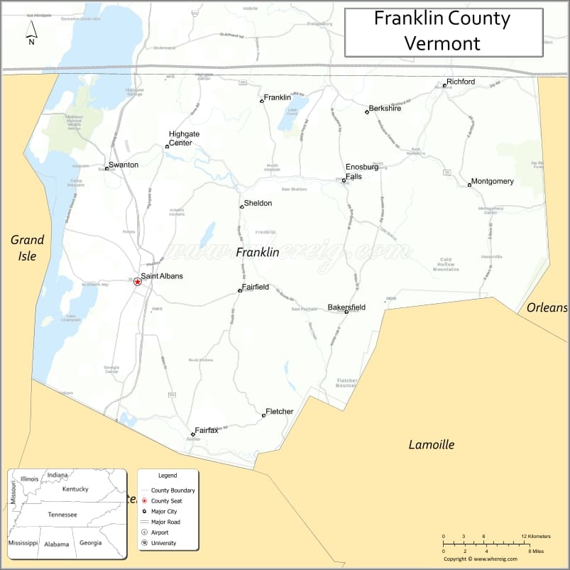
About Franklin County Map, Alabama: The map showing the county boundary, county seat, major cities, highways, water bodies and neighbouring counties.
Most Viewed Links
Map of Franklin County, Vermont
Westmoreland County is a county located in the U.S. state of Virginia. It`s county seat is Montross. As per 2020 census, the population of Westmoreland County was 18731 and population density of Westmoreland was square miles. According to the United States Census Bureau, the county has a total area of 229 sq mi (593 km2). Westmoreland County was established on 1653.
Franklin County Facts
| Continent | North America |
| Country | United States |
| State | Vermont |
| County Seat | St. Albans |
| Largest City/Town | St. Albans |
| Established | 1792 |
| Total Area | 692 sq mi (1,792 sq km) |
| Land Area | 634 sq mi (1,642 sq km) |
| Water Area | 58 sq mi (150 sq km) |
| Population | 49,887 (Census 2020) |
| Population Density | 78.7 people per sq mi |
| Time Zone | Eastern Time Zone (ET) |
| Major Highways | Interstate 89, U.S. Route 2, U.S. Route 7, VT Route 36, VT Route 105 |
| Major Rivers | Missisquoi River, Lamoille River, Trout River |
| Neighboring Counties | Grand Isle County, Chittenden County, Lamoille County, Orleans County, Brome-Missisquoi (Quebec) |
| Famous For | Lake Champlain, dairy farming, maple syrup, Missisquoi National Wildlife Refuge, and border crossings to Canada |
| Top Attractions | St. Albans Bay, Missisquoi National Wildlife Refuge, Lake Champlain, Sheldon Museum, Rail Trail |
| Official Website | Official Website |
About Franklin County, Vermont
Franklin County is located in the northwestern part of Vermont along the Canadian border and was established in 1792. The county seat is St. Albans, which is also the largest city in the county. Franklin County is known for its agricultural heritage, scenic lakefront areas, and access to outdoor recreation near Lake Champlain and the Missisquoi River Valley.
Cities and Towns in Franklin County, Vermont
| City/Town | Population (Census 2020) | Latitude & Longitude |
|---|---|---|
| St. Albans (county seat) | 6,877 | 44.8106°N, 73.0832°W |
| Swanton | 6,701 | 44.9189°N, 73.1232°W |
| Franklin | 1,691 | 44.9659°N, 72.9101°W |
| Highgate | 3,472 | 44.9370°N, 73.0471°W |
| Berkshire | 2,029 | 44.9498°N, 72.7754°W |
| Enosburgh | 2,758 | 44.9053°N, 72.8051°W |
| Fairfax | 5,014 | 44.6645°N, 73.0243°W |
| Fairfield | 1,992 | 44.7965°N, 72.9940°W |
| Georgia | 4,740 | 44.6878°N, 73.0846°W |
| Montgomery | 1,196 | 44.8776°N, 72.6426°W |
| Richford | 2,346 | 44.9967°N, 72.6712°W |
| Sheldon | 2,156 | 44.8868°N, 72.9371°W |
| St. Albans Town | 6,701 | 44.8367°N, 73.0924°W |
| Bakersfield | 1,322 | 44.7912°N, 72.8037°W |
| Holland | 632 | 44.9734°N, 72.0571°W |
| Westfield | 566 | 44.8854°N, 72.4279°W |
| Alburgh | 2,129 | 44.9712°N, 73.3001°W |
| South Hero | 1,816 | 44.6451°N, 73.3043°W |
| Swanton Village (CDP) | 2,554 | 44.9181°N, 73.1246°W |
| Enosburg Falls (CDP) | 1,296 | 44.9067°N, 72.8070°W |
Best Golf Courses in Franklin County, Vermont
| Golf Course | Location | Latitude & Longitude |
|---|---|---|
| Champlain Country Club | Swanton | 44.9324°N, 73.1235°W |
| Enosburg Falls Country Club | Enosburgh | 44.9038°N, 72.8126°W |
| St. Albans Country Club | St. Albans | 44.8339°N, 73.1028°W |
| Bakersfield Country Club | Bakersfield | 44.7906°N, 72.8044°W |
| Champlain Golf Links | Georgia | 44.6988°N, 73.0961°W |
What are Major Roads and Highways in Franklin County
Major highways connect the county to nearby regions and cities.
- Interstate 89 - major north-south interstate connecting St. Albans with Burlington and Canada
- U.S. Route 2 - east-west route linking St. Albans with Grand Isle County and northern Vermont towns
- U.S. Route 7 - highway connecting Franklin County with Chittenden County and Montreal routes
- VT Route 36 - local corridor serving St. Albans Bay and nearby lakefront communities
- VT Route 105 - scenic route through Richford and northern Vermont countryside
Neighboring Counties of Franklin County
- Grand Isle County (west)
- Chittenden County (south)
- Lamoille County (southeast)
- Orleans County (east)
- Brome-Missisquoi, Quebec (north)
What are Top Attractions in Franklin County, Vermont
The county offers a mix of natural and cultural attractions.
| Main Sight Name | City | Famous For |
|---|---|---|
| Missisquoi National Wildlife Refuge | Swanton | Birdwatching, wetlands, and wildlife habitats |
| Lake Champlain | St. Albans Bay | Boating, fishing, and waterfront recreation |
| St. Albans Historical Museum | St. Albans | Regional history and Civil War exhibits |
| Hard'ack Recreation Area | St. Albans | Ski hill, hiking trails, and outdoor sports |
| Rail City Trail | St. Albans | Walking and biking trail through the city |
| Jay Peak Nearby Region | Montgomery | Skiing and mountain recreation close to the county |
| Missisquoi Valley Rail Trail | Richford | Scenic trail for biking and snowmobiling |
| St. Albans Bay Park | St. Albans | Beach access and summer recreation |
| Sheldon Museum | Fairfield | Local agricultural and rural history |
| Hathaway Point | Alburgh | Lake Champlain scenic views and boating |
| Comstock Covered Bridge | Montgomery | Historic wooden covered bridge |
| Montgomery Covered Bridges | Montgomery | Collection of famous Vermont covered bridges |
Distance from Franklin County to Nearby Cities
The following distances are measured by road (driving).
- St. Albans to Burlington (Chittenden County), Vermont - 29 mi (47 km)
- St. Albans to Montpelier (Washington County), Vermont - 52 mi (84 km)
- St. Albans to Newport (Orleans County), Vermont - 41 mi (66 km)
- St. Albans to Swanton (Franklin County), Vermont - 7 mi (11 km)
- St. Albans to Richford (Franklin County), Vermont - 31 mi (50 km)
- St. Albans to Montreal, Quebec - 48 mi (77 km)
- St. Albans to Plattsburgh, New York - 49 mi (79 km)
- St. Albans to Stowe (Lamoille County), Vermont - 41 mi (66 km)
- St. Albans to Barre (Washington County), Vermont - 58 mi (93 km)
- St. Albans to Middlebury (Addison County), Vermont - 63 mi (101 km)
- St. Albans to Rutland (Rutland County), Vermont - 95 mi (153 km)
- St. Albans to Sherbrooke, Quebec - 76 mi (122 km)
- St. Albans to Concord, New Hampshire - 143 mi (230 km)
- St. Albans to Albany, New York - 157 mi (253 km)
References
- QuickFacts - U.S. Census Bureau
- United States Census Bureau
- United States Geological Survey (USGS)
- National Geodetic Survey
- Official County Website
- Alabama Counties
- Alaska boroughs
- Arizona Counties
- Arkansas Counties
- California County Map
- Colorado Counties
- Connecticut Counties
- Delaware Counties
- Florida County Map
- Georgia County Map
- Hawaii Counties
- Idaho Counties
- Illinois Counties
- Indiana Counties
- Iowa Counties
- Kansas Counties
- Kentucky Counties
- Louisiana Counties
- Maine Counties
- Maryland Counties
- Massachusetts Counties
- Michigan County Map
- Minnesota Counties
- Mississippi Counties
- Missouri Counties
- Montana Counties
- Nebraska Counties
- Nevada Counties
- New York Counties
- New Hampshire Counties
- New Jersey Counties
- New Mexico Counties
- North Carolina Counties
- North Dakota Counties
- Ohio County Map
- Oklahoma Counties
- Oregon Counties
- Pennsylvania Counties
- Rhode Island Counties
- South Carolina Counties
- South Dakota Counties
- Map of Tennessee
- Texas County Map
- Utah Counties
- Vermont Counties
- Virginia Counties
- Washington Counties
- West Virginia Counties
- Wisconsin Counties
- Wyoming Counties