Map of Addison County - Addison County is a county located in the U.S. state of Vermont. Addison County Map showing cities, highways, important places and water bodies. Get Where is Addison County located in the map, major cities in Addison county, population, areas, and places of interest.
Map of Addison County, Vermont
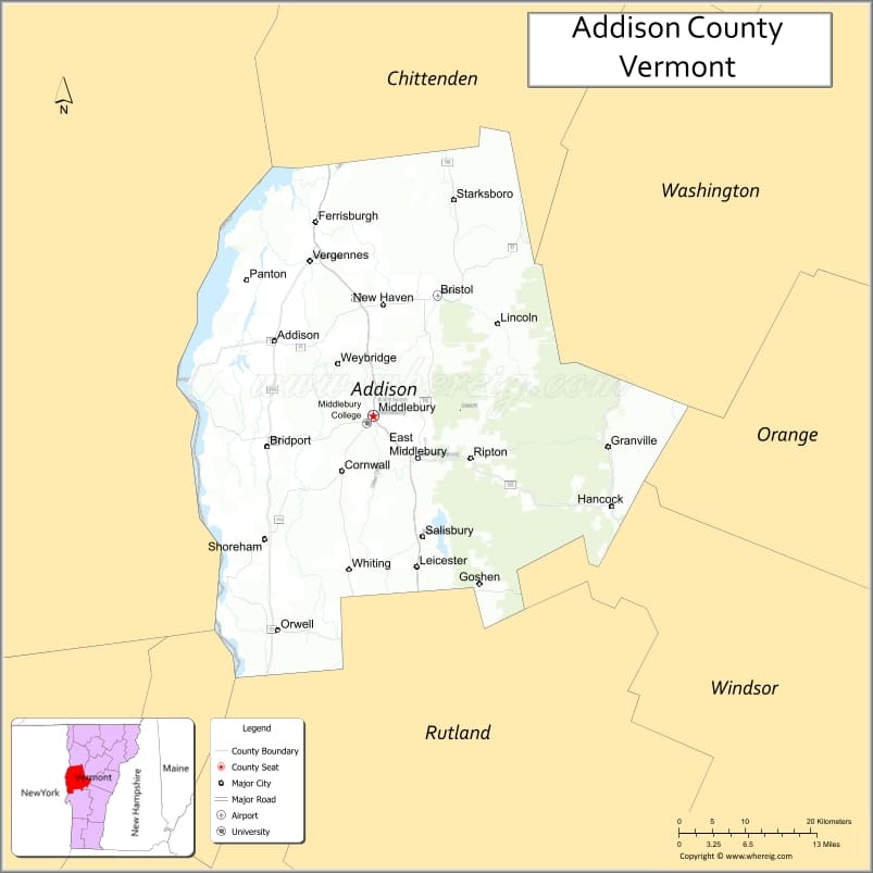
About Addison County Map, Alabama: The map showing the county boundary, county seat, major cities, highways, water bodies and neighbouring counties.
Most Viewed Links
Map of Addison County, Vermont
Richmond County is a county located in the U.S. state of Virginia. It`s county seat is Warsaw. As per 2020 census, the population of Richmond County was 9017 and population density of Richmond was square miles. According to the United States Census Bureau, the county has a total area of 192 sq mi (497 km2). Richmond County was established on 1692.
Addison County Facts
| Continent | North America |
| Country | United States |
| State | Vermont |
| County Seat | Middlebury |
| Largest City/Town | Middlebury |
| Established | 1785 |
| Total Area | 808 sq mi (2,093 sq km) |
| Land Area | 766 sq mi (1,984 sq km) |
| Water Area | 42 sq mi (109 sq km) |
| Population | 37,363 (Census 2020) |
| Population Density | 48.8 people per sq mi |
| Time Zone | Eastern Time Zone (ET) |
| Major Highways | U.S. Route 7, VT Route 17, VT Route 22A, VT Route 30, VT Route 125 |
| Major Rivers | Otter Creek, New Haven River, Lemon Fair River |
| Neighboring Counties | Chittenden County, Washington County, Orange County, Rutland County, Essex County (NY) |
| Famous For | Middlebury College, Lake Champlain, covered bridges, Green Mountains, farming and maple syrup |
| Top Attractions | Middlebury College, Lake Champlain, Chimney Point State Historic Site, Snake Mountain, Branbury State Park |
| Official Website | Official Website |
About Addison County, Vermont
Addison County is located in the western part of Vermont along the eastern shore of Lake Champlain and was established in 1785. The county seat is Middlebury, which is also the largest town in the county. Addison County is known for its rural landscapes, mountain scenery, dairy farms, and outdoor recreation areas connected to both the Green Mountains and Lake Champlain.
Cities and Towns in Addison County, Vermont
| City/Town | Population (Census 2020) | Latitude & Longitude |
|---|---|---|
| Middlebury (county seat) | 9,152 | 44.0153°N, 73.1673°W |
| Bristol | 3,828 | 44.1334°N, 73.0790°W |
| Vergennes | 2,553 | 44.1673°N, 73.2540°W |
| Bridport | 1,218 | 44.0326°N, 73.3087°W |
| Cornwall | 1,269 | 43.9937°N, 73.1662°W |
| Ferrisburgh | 2,944 | 44.2178°N, 73.2476°W |
| Goshen | 164 | 43.8750°N, 73.0008°W |
| Granville | 301 | 44.0048°N, 72.8390°W |
| Hancock | 323 | 43.9395°N, 72.9495°W |
| Leicester | 1,040 | 43.8673°N, 73.1062°W |
| Lincoln | 1,271 | 44.0856°N, 72.9973°W |
| Monkton | 2,106 | 44.2303°N, 73.1273°W |
| New Haven | 1,729 | 44.1237°N, 73.1720°W |
| Orwell | 1,239 | 43.7912°N, 73.2968°W |
| Panton | 677 | 44.2245°N, 73.2804°W |
| Ripton | 739 | 43.9753°N, 72.9867°W |
| Salisbury | 1,123 | 43.8962°N, 73.1145°W |
| Shoreham | 1,264 | 43.8915°N, 73.3140°W |
| Starksboro | 1,810 | 44.2278°N, 73.0576°W |
| Waltham | 486 | 44.1331°N, 73.2607°W |
| Weybridge | 833 | 44.0698°N, 73.2029°W |
| Whiting | 405 | 43.8648°N, 73.1695°W |
Best Golf Courses in Addison County, Vermont
| Golf Course | Location | Latitude & Longitude |
|---|---|---|
| Middlebury College Golf Course | Middlebury | 44.0105°N, 73.1845°W |
| Ralph Myhre Golf Course | Middlebury | 44.0078°N, 73.1810°W |
| Basin Harbor Club Golf Course | Vergennes | 44.1255°N, 73.3691°W |
What are Major Roads and Highways in Addison County
Major highways connect the county to nearby regions and cities.
- U.S. Route 7 - runs north-south through Middlebury connecting Burlington and Rutland
- VT Route 17 - connects Addison County to the Mad River Valley and Interstate 89
- VT Route 22A - western corridor linking Vergennes and Fair Haven
- VT Route 30 - travels south through Orwell toward Rutland County
- VT Route 125 - scenic mountain route connecting Middlebury Gap and Hancock
Neighboring Counties of Addison County
- Chittenden County (north)
- Washington County (east)
- Orange County (east)
- Rutland County (south)
- Essex County, New York (west across Lake Champlain)
What are Top Attractions in Addison County, Vermont
The county offers a mix of natural and cultural attractions.
| Main Sight Name | City | Famous For |
|---|---|---|
| Middlebury College | Middlebury | Historic liberal arts college and scenic campus |
| Lake Champlain | Vergennes Area | Boating, fishing, lakeside views, and recreation |
| Chimney Point State Historic Site | Addison | Historic bridge crossing and museum on Lake Champlain |
| Snake Mountain | Weybridge | Popular hiking destination with panoramic views |
| Branbury State Park | Salisbury | Camping and swimming along Lake Dunmore |
| Lake Dunmore | Salisbury | Boating, fishing, and mountain scenery |
| Robert Frost Interpretive Trail | Ripton | Nature trail honoring poet Robert Frost |
| Vergennes Falls Park | Vergennes | Waterfalls and downtown river scenery |
| Mount Abraham | Lincoln | Green Mountain hiking and summit views |
| Basin Harbor | Vergennes | Historic lakeside resort and marina |
| Otter Creek | Middlebury | Kayaking, fishing, and scenic river views |
| Henry Sheldon Museum | Middlebury | Local history and Vermont cultural exhibits |
Distance from Addison County to Nearby Cities
The following distances are measured by road (driving).
- Middlebury to Burlington (Chittenden County), Vermont - 35 mi (56 km)
- Middlebury to Rutland (Rutland County), Vermont - 33 mi (53 km)
- Middlebury to Montpelier (Washington County), Vermont - 52 mi (84 km)
- Middlebury to Vergennes (Addison County), Vermont - 12 mi (19 km)
- Middlebury to Bristol (Addison County), Vermont - 16 mi (26 km)
- Middlebury to Stowe (Lamoille County), Vermont - 67 mi (108 km)
- Middlebury to Plattsburgh, New York - 78 mi (126 km)
- Middlebury to Albany, New York - 118 mi (190 km)
- Middlebury to Lebanon, New Hampshire - 91 mi (146 km)
- Middlebury to Barre (Washington County), Vermont - 57 mi (92 km)
- Middlebury to Bennington (Bennington County), Vermont - 98 mi (158 km)
- Middlebury to Manchester (Bennington County), Vermont - 68 mi (109 km)
- Middlebury to Ticonderoga, New York - 42 mi (68 km)
- Middlebury to Essex Junction (Chittenden County), Vermont - 41 mi (66 km)
References
- QuickFacts - U.S. Census Bureau
- United States Census Bureau
- United States Geological Survey (USGS)
- National Geodetic Survey
- Official County Website
- Alabama Counties
- Alaska boroughs
- Arizona Counties
- Arkansas Counties
- California County Map
- Colorado Counties
- Connecticut Counties
- Delaware Counties
- Florida County Map
- Georgia County Map
- Hawaii Counties
- Idaho Counties
- Illinois Counties
- Indiana Counties
- Iowa Counties
- Kansas Counties
- Kentucky Counties
- Louisiana Counties
- Maine Counties
- Maryland Counties
- Massachusetts Counties
- Michigan County Map
- Minnesota Counties
- Mississippi Counties
- Missouri Counties
- Montana Counties
- Nebraska Counties
- Nevada Counties
- New York Counties
- New Hampshire Counties
- New Jersey Counties
- New Mexico Counties
- North Carolina Counties
- North Dakota Counties
- Ohio County Map
- Oklahoma Counties
- Oregon Counties
- Pennsylvania Counties
- Rhode Island Counties
- South Carolina Counties
- South Dakota Counties
- Map of Tennessee
- Texas County Map
- Utah Counties
- Vermont Counties
- Virginia Counties
- Washington Counties
- West Virginia Counties
- Wisconsin Counties
- Wyoming Counties