Written and fact-checked by Whereig.com Web Team | Last Updated: December 16, 2025, 14:30 ET
Map of Nevada County - Nevada County is a county located in the U.S. state of California. Nevada County Map showing cities, highways, important places and water bodies. Get Where is Nevada County located in the map, major cities in Nevada county, population, areas, and places of interest.
Nevada County Map, California
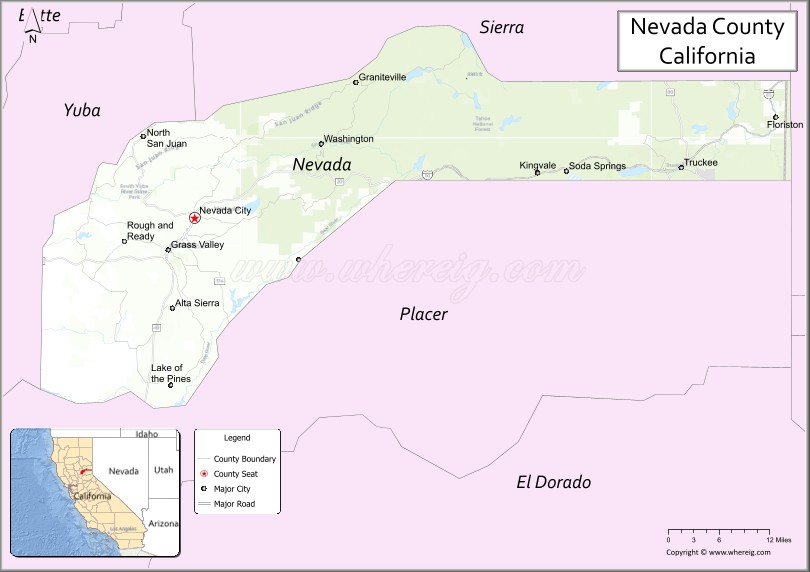
About Nevada County Map, California: The map showing the county boundary, county seat, major cities, highways, water bodies and neighbouring counties.
Most Viewed Links
About Nevada County, California
Nevada County is a county located in the U.S. state of California. It's county seat is Nevada City. As per 2020 census, the population of Nevada County is 103487 people and population density is square miles. According to the United States Census Bureau, the county has a total area of 958 sq mi (2,481 km2). Nevada County was established on 1851.
Nevada County is known for its beautiful natural scenery, which includes forests, lakes, rivers, and mountains. The county is home to several popular outdoor recreation areas, such as the Tahoe National Forest, the South Yuba River State Park, and the Donner Memorial State Park. These areas offer a wide range of activities, including hiking, camping, fishing, and skiing.
The county has a rich history, dating back to the Gold Rush era of the mid-1800s. Many of the towns in the county, such as Grass Valley and Nevada City, were founded during this time and still retain much of their historic charm. The county is also home to several museums and historic sites, including the Nevada County Narrow Gauge Railroad Museum and the Empire Mine State Historic Park.
In addition to its natural beauty and rich history, Nevada County is known for its vibrant arts and culture scene. The county is home to many art galleries, theaters, and music venues, and hosts several festivals and events throughout the year, such as the Nevada City Film Festival and the WorldFest music festival.
Facts about Nevada County, California
| Country | United States |
| State | California |
| Region | Sierra Nevada foothills |
| County Seat | Nevada City |
| Named After | Spanish word “Nevada,” meaning “snowy” |
| Established | 1851 |
| Organized | 1851 |
| Coordinates | 39.3039° N, 120.7688° W |
| Total Area | 974 sq mi |
| Land Area | 958 sq mi |
| Water Area | 16 sq mi |
| Population (2020) | 102,241 |
| Population Rank | Small-to-mid-sized county in California |
| Major Cities | Grass Valley, Nevada City |
| Main Industries | Tourism, Government Services, Healthcare, Technology |
| Major Airport | Nevada County Airport |
| Time Zone | Pacific Time (UTC−08:00) |
| Known For | Gold Rush history, Historic towns, Outdoor recreation, Scenic foothills |
| Website | https://www.mynevadacounty.com |
Ctities and Towns in Nevada County
| City Name | Type | Population (2020) | Pop. Density | Area | Incorporated |
|---|---|---|---|---|---|
| Grass Valley | City | 14,016 | 2,669.7/sq mi (1,030.8/km2) | 5.25 sq mi (13.6 km2) | March 13, 1893 |
| Nevada City | City | 3,152 | 1,439.3/sq mi (555.7/km2) | 2.19 sq mi (5.7 km2) | April 19, 1856 |
| Truckee | Town | 16,729 | 517.4/sq mi (199.8/km2) | 32.33 sq mi (83.7 km2) | March 23, 1993 |
Places to Visit in Nevada County
Top places to visit in Nevada includes Malakoff Diggins State Historic, Lake Tahoe, Boreal Mountain California, South Yuba River State Park, Empire Mine State Historic, Crystal Hermitage, Donner Ski Ranch, Tahoe Donner Downhill Ski, Donner Memorial State Park, West End Beach, Western Gateway Park, Bridgeport Covered Bridge, Soda Springs Mountain Resort, Sand Harbor, Donner Summit Bridge, Old Greenwood Golf Course, Coyote Moon Golf Course.
Highways in Nevada County
Interstate 80, State Route 20, State Route 49, State Route 89, State Route 174.
Nearest Airports
Nearest airport of Nevada is Sacramento (SMF) Airport.
- Alameda County Map
- Alpine County Map
- Amador County Map
- Butte County Map
- Calaveras County Map
- Colusa County Map
- Contra Costa County Map
- Del Norte County Map
- El Dorado County Map
- Fresno County Map
- Glenn County Map
- Humboldt County Map
- Imperial County Map
- Inyo County Map
- Kern County Map
- Kings County Map
- Lake County Map
- Lassen County Map
- Los Angeles County Map
- Madera County Map
- Marin County Map
- Mariposa County Map
- Mendocino County Map
- Merced County Map
- Modoc County Map
- Mono County Map
- Monterey County Map
- Napa County Map
- Nevada County Map
- Orange County Map
- Placer County Map
- Plumas County Map
- Riverside County Map
- Sacramento County Map
- San Benito County Map
- San Bernardino County Map
- San Diego County Map
- San Francisco County Map
- San Joaquin County Map
- San Luis Obispo County Map
- San Mateo County Map
- Santa Barbara County Map
- Santa Clara County Map
- Santa Cruz County Map
- Shasta County Map
- Sierra County Map
- Siskiyou County Map
- Solano County Map
- Sonoma County Map
- Stanislaus County Map
- Sutter County Map
- Tehama County Map
- Trinity County Map
- Tulare County Map
- Tuolumne County Map
- Ventura County Map
- Yolo County Map
- Yuba County Map
- Alabama Counties
- Alaska boroughs
- Arizona Counties
- Arkansas Counties
- California County Map
- Colorado Counties
- Connecticut Counties
- Delaware Counties
- Florida County Map
- Georgia County Map
- Hawaii Counties
- Idaho Counties
- Illinois Counties
- Indiana Counties
- Iowa Counties
- Kansas Counties
- Kentucky Counties
- Louisiana Counties
- Maine Counties
- Maryland Counties
- Massachusetts Counties
- Michigan County Map
- Minnesota Counties
- Mississippi Counties
- Missouri Counties
- Montana Counties
- Nebraska Counties
- Nevada Counties
- New York Counties
- New Hampshire Counties
- New Jersey Counties
- New Mexico Counties
- North Carolina Counties
- North Dakota Counties
- Ohio County Map
- Oklahoma Counties
- Oregon Counties
- Pennsylvania Counties
- Rhode Island Counties
- South Carolina Counties
- South Dakota Counties
- Map of Tennessee
- Texas County Map
- Utah Counties
- Vermont Counties
- Virginia Counties
- Washington Counties
- West Virginia Counties
- Wisconsin Counties
- Wyoming Counties