Written and fact-checked by Whereig.com Web Team | Last Updated: December 16, 2025, 14:30 ET
Map of Colusa County - Colusa County is a county located in the U.S. state of California. Colusa County Map showing cities, highways, important places and water bodies. Get Where is Colusa County located in the map, major cities in Colusa county, population, areas, and places of interest.
Colusa County Map, California
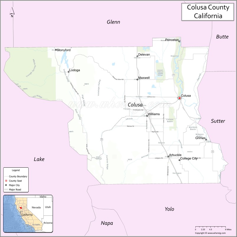
About Colusa County Map, California: The map showing the county boundary, county seat, major cities, highways, water bodies and neighbouring counties.
Most Viewed Links
About Colusa County, California
Colusa County is a county located in the north-central part of the U.S. state of California. It is situated in the Sacramento Valley region, and its county seat is the city of Colusa. The county is bordered by Glenn County to the north, Butte County to the northeast, Yuba County to the east, Lake County to the southeast, Napa County to the southwest, and Lake County to the northwest.
As of the 2020 Census, the population of Colusa County was estimated to be around 21,000 people. The county has a total area of 1,156 square miles (2,994 km²), of which 1,151 square miles (2,981 km²) is land and 5.0 square miles (13 km²) is water.Colusa County was established on 1850.
Colusa County is known for its agriculture, with crops including rice, almonds, walnuts, and prunes. Outdoor recreation is also popular in the area, with opportunities for hunting, fishing, boating, and hiking. Some of the top attractions in Colusa County include the Colusa-Sacramento River State Recreation Area, the Colusa County Courthouse, and the Sacramento National Wildlife Refuge.
Facts about Colusa County, California
| Country | United States |
| State | California |
| Region | Northern California (Sacramento Valley) |
| County Seat | Colusa |
| Named After | Rancho Colus, a Mexican land grant |
| Established | 1850 |
| Organized | 1850 |
| Coordinates | 39.1785° N, 122.2377° W |
| Total Area | 1,156 sq mi |
| Land Area | 1,151 sq mi |
| Water Area | 5 sq mi |
| Population (2020) | 21,839 |
| Population Rank | One of the least populous counties in California |
| Major Cities | Colusa, Williams |
| Main Industries | Agriculture, Food Processing, Government Services |
| Major Airport | None (nearest commercial airports outside the county) |
| Time Zone | Pacific Time (UTC−08:00) |
| Known For | Rice and almond farming, Sacramento River, Rural agricultural landscape |
| Website | https://www.countyofcolusa.org |
Ctities and Towns in Colusa County County
| City Name | Type | Population (2020) | Pop. Density | Area | Incorporated |
|---|---|---|---|---|---|
| Angels Camp | City | 3,667 | 1,010.2/sq mi (390.0/km2) | 3.63 sq mi (9.4 km2) | January 16, 1912 |
| Colusa | City | 6,411 | 1,874.6/sq mi (723.8/km2) | 3.42 sq mi (8.9 km2) | June 16, 1868 |
| Williams | City | 5,538 | 1,118.8/sq mi (432.0/km2) | 4.95 sq mi (12.8 km2) | May 17, 1920 |
Places to Visit in Colusa County County
Top places to visit in Colusa includes Colusa-Sacramento River, Colusa Levee Scenic Park, Colusa National Wildlife Refuge, Colusa Golf and Country Club, Gray Lodge Wildlife Area, Sacramento Valley Museum.
Highways in Colusa County
Interstate 5, State Route 16, State Route 20, State Route 45.
Nearest Airports
Nearest airport of Colusa is Colusa County Airport.
- Alameda County Map
- Alpine County Map
- Amador County Map
- Butte County Map
- Calaveras County Map
- Colusa County Map
- Contra Costa County Map
- Del Norte County Map
- El Dorado County Map
- Fresno County Map
- Glenn County Map
- Humboldt County Map
- Imperial County Map
- Inyo County Map
- Kern County Map
- Kings County Map
- Lake County Map
- Lassen County Map
- Los Angeles County Map
- Madera County Map
- Marin County Map
- Mariposa County Map
- Mendocino County Map
- Merced County Map
- Modoc County Map
- Mono County Map
- Monterey County Map
- Napa County Map
- Nevada County Map
- Orange County Map
- Placer County Map
- Plumas County Map
- Riverside County Map
- Sacramento County Map
- San Benito County Map
- San Bernardino County Map
- San Diego County Map
- San Francisco County Map
- San Joaquin County Map
- San Luis Obispo County Map
- San Mateo County Map
- Santa Barbara County Map
- Santa Clara County Map
- Santa Cruz County Map
- Shasta County Map
- Sierra County Map
- Siskiyou County Map
- Solano County Map
- Sonoma County Map
- Stanislaus County Map
- Sutter County Map
- Tehama County Map
- Trinity County Map
- Tulare County Map
- Tuolumne County Map
- Ventura County Map
- Yolo County Map
- Yuba County Map
- Alabama Counties
- Alaska boroughs
- Arizona Counties
- Arkansas Counties
- California County Map
- Colorado Counties
- Connecticut Counties
- Delaware Counties
- Florida County Map
- Georgia County Map
- Hawaii Counties
- Idaho Counties
- Illinois Counties
- Indiana Counties
- Iowa Counties
- Kansas Counties
- Kentucky Counties
- Louisiana Counties
- Maine Counties
- Maryland Counties
- Massachusetts Counties
- Michigan County Map
- Minnesota Counties
- Mississippi Counties
- Missouri Counties
- Montana Counties
- Nebraska Counties
- Nevada Counties
- New York Counties
- New Hampshire Counties
- New Jersey Counties
- New Mexico Counties
- North Carolina Counties
- North Dakota Counties
- Ohio County Map
- Oklahoma Counties
- Oregon Counties
- Pennsylvania Counties
- Rhode Island Counties
- South Carolina Counties
- South Dakota Counties
- Map of Tennessee
- Texas County Map
- Utah Counties
- Vermont Counties
- Virginia Counties
- Washington Counties
- West Virginia Counties
- Wisconsin Counties
- Wyoming Counties