Written and fact-checked by Whereig.com Web Team | Last Updated: December 16, 2025, 14:30 ET
Map of San Luis Obispo County - San Luis Obispo County is a county located in the U.S. state of California. San Luis Obispo County Map showing cities, highways, important places and water bodies. Get Where is San Luis Obispo County located in the map, major cities in San Luis Obispo county, population, areas, and places of interest.
San Luis Obispo County Map, California
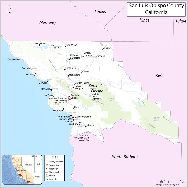
About San Luis Obispo County Map, California: The map showing the county boundary, county seat, major cities, highways, water bodies and neighbouring counties.
Most Viewed Links
About San Luis Obispo County, California
San Luis Obispo County is a county located in central California, It's county seat is San Luis Obispo. As per 2020 census, the population of San Luis Obispo County is 283159 people and population density is square miles. According to the United States Census Bureau, the county has a total area of 3,304 sq mi (8,557 km2). San Luis Obispo County was established on 1850.
San Luis Obispo County is known for its beautiful coastline, wineries, and outdoor recreation opportunities. Some of the popular destinations in the county include the Hearst Castle, Morro Bay, and Pismo Beach. The county is also home to several universities and colleges, including California Polytechnic State University, San Luis Obispo and Cuesta College.
Economically, San Luis Obispo County is driven by a mix of industries, including tourism, agriculture, healthcare, and technology. The county is also home to several military installations, including Camp Roberts and Fort Hunter Liggett. Additionally, the county is known for its sustainability initiatives, including efforts to promote clean energy and reduce waste.
San Luis Obispo County has a high quality of life, with a strong emphasis on community engagement and environmental stewardship. The county's natural beauty and diverse economy have contributed to its growth and development, making it a desirable place to live and visit.
Facts about San Luis Obispo County, California
| Country | United States |
| State | California |
| Region | Central Coast California |
| County Seat | San Luis Obispo |
| Named After | Mission San Luis Obispo de Tolosa |
| Established | 1850 |
| Organized | 1850 |
| Coordinates | 35.3852° N, 120.4470° W |
| Total Area | 3,616 sq mi |
| Land Area | 3,299 sq mi |
| Water Area | 317 sq mi |
| Population (2020) | 282,424 |
| Population Rank | Mid-sized county in California |
| Major Cities | San Luis Obispo, Paso Robles, Atascadero |
| Main Industries | Agriculture, Tourism, Education, Wine Production |
| Major Airport | San Luis Obispo County Regional Airport |
| Time Zone | Pacific Time (UTC−08:00) |
| Known For | Central Coast beaches, Wine country, Hearst Castle, Scenic coastal landscapes |
| Website | https://www.slocounty.ca.gov |
Ctities and Towns in San Luis Obispo County
| City Name | Type | Population (2020) | Pop. Density | Area | Incorporated |
|---|---|---|---|---|---|
| Arroyo Grande | City | 18,441 | 3,104.5/sq mi (1,198.7/km2) | 5.94 sq mi (15.4 km2) | July 10, 1911 |
| Atascadero | City | 29,773 | 1,142.0/sq mi (440.9/km2) | 26.07 sq mi (67.5 km2) | July 2, 1979 |
| Grover Beach | City | 12,701 | 5,498.3/sq mi (2,122.9/km2) | 2.31 sq mi (6 km2) | December 21, 1959 |
| Morro Bay | City | 10,757 | 2,018.2/sq mi (779.2/km2) | 5.33 sq mi (13.8 km2) | July 17, 1964 |
| Paso Robles | City | 31,490 | 1,602.5/sq mi (618.7/km2) | 19.65 sq mi (50.9 km2) | March 11, 1889 |
| Pismo Beach | City | 8,072 | 2,306.3/sq mi (890.5/km2) | 3.5 sq mi (9.1 km2) | April 25, 1946 |
| San Luis Obispo | City | 47,063 | 3,535.9/sq mi (1,365.2/km2) | 13.31 sq mi (34.5 km2) | February 16, 1856 |
Places to Visit in San Luis Obispo County
Top places to visit in San Luis Obispo includes Madonna Inn, San Luis Obispo Museum of Art, Bishop Peak, Sunset Drive-In, Avila Valley Barn, .
Highways in San Luis Obispo County
U.S. Route 101, State Route 1, State Route 33, State Route 41, State Route 46, State Route 58, State Route 166, State Route 227, State Route 229.
Nearest Airports
Nearest airport of San Luis Obispo is San Luis Obispo County Regional Airport.
- Alameda County Map
- Alpine County Map
- Amador County Map
- Butte County Map
- Calaveras County Map
- Colusa County Map
- Contra Costa County Map
- Del Norte County Map
- El Dorado County Map
- Fresno County Map
- Glenn County Map
- Humboldt County Map
- Imperial County Map
- Inyo County Map
- Kern County Map
- Kings County Map
- Lake County Map
- Lassen County Map
- Los Angeles County Map
- Madera County Map
- Marin County Map
- Mariposa County Map
- Mendocino County Map
- Merced County Map
- Modoc County Map
- Mono County Map
- Monterey County Map
- Napa County Map
- Nevada County Map
- Orange County Map
- Placer County Map
- Plumas County Map
- Riverside County Map
- Sacramento County Map
- San Benito County Map
- San Bernardino County Map
- San Diego County Map
- San Francisco County Map
- San Joaquin County Map
- San Luis Obispo County Map
- San Mateo County Map
- Santa Barbara County Map
- Santa Clara County Map
- Santa Cruz County Map
- Shasta County Map
- Sierra County Map
- Siskiyou County Map
- Solano County Map
- Sonoma County Map
- Stanislaus County Map
- Sutter County Map
- Tehama County Map
- Trinity County Map
- Tulare County Map
- Tuolumne County Map
- Ventura County Map
- Yolo County Map
- Yuba County Map
- Alabama Counties
- Alaska boroughs
- Arizona Counties
- Arkansas Counties
- California County Map
- Colorado Counties
- Connecticut Counties
- Delaware Counties
- Florida County Map
- Georgia County Map
- Hawaii Counties
- Idaho Counties
- Illinois Counties
- Indiana Counties
- Iowa Counties
- Kansas Counties
- Kentucky Counties
- Louisiana Counties
- Maine Counties
- Maryland Counties
- Massachusetts Counties
- Michigan County Map
- Minnesota Counties
- Mississippi Counties
- Missouri Counties
- Montana Counties
- Nebraska Counties
- Nevada Counties
- New York Counties
- New Hampshire Counties
- New Jersey Counties
- New Mexico Counties
- North Carolina Counties
- North Dakota Counties
- Ohio County Map
- Oklahoma Counties
- Oregon Counties
- Pennsylvania Counties
- Rhode Island Counties
- South Carolina Counties
- South Dakota Counties
- Map of Tennessee
- Texas County Map
- Utah Counties
- Vermont Counties
- Virginia Counties
- Washington Counties
- West Virginia Counties
- Wisconsin Counties
- Wyoming Counties