Written and fact-checked by Whereig.com Web Team | Last Updated: December 16, 2025, 14:30 ET
Map of Kern County - Kern County is a county located in the U.S. state of California. Kern County Map showing cities, highways, important places and water bodies. Get Where is Kern County located in the map, major cities in Kern county, population, areas, and places of interest.
Kern County Map, California
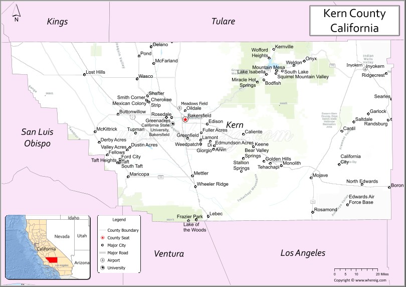
About Kern County Map, California: The map showing the county boundary, county seat, major cities, highways, water bodies and neighbouring counties.
Most Viewed Links
About Kern County, California
Kern County is a county located in the southern part of the state of California in the United States. Its county seat is Bakersfield. The county is known for its diverse economy, which includes agriculture, oil and gas production, aerospace, and manufacturing.
Kern County has a population of approximately 900,000 people and covers an area of about 8,163 square miles. The county is the largest producer of oil in the state of California and is also a major producer of agriculture products such as grapes, almonds, and citrus fruits. The Tehachapi Mountains, part of the Sierra Nevada range, also run through the eastern part of the county, providing opportunities for outdoor recreational activities.
Bakersfield is the largest community in Kern County and serves as the county seat. Other communities in the county include Delano, Ridgecrest, Tehachapi, and California City.
Facts about Kern County, California
| Country | United States |
| State | California |
| Region | Southern & Central California (San Joaquin Valley, Mojave Desert, Sierra Nevada) |
| County Seat | Bakersfield |
| Named After | Edward M. Kern |
| Established | 1866 |
| Organized | 1866 |
| Coordinates | 35.3429° N, 118.7299° W |
| Total Area | 8,163 sq mi |
| Land Area | 8,141 sq mi |
| Water Area | 22 sq mi |
| Population (2020) | 909,235 |
| Population Rank | One of the largest counties in California |
| Major Cities | Bakersfield, Delano, Ridgecrest, Tehachapi |
| Main Industries | Energy (oil & gas), Agriculture, Aerospace, Manufacturing, Government Services |
| Major Airport | Meadows Field Airport |
| Time Zone | Pacific Time (UTC−08:00) |
| Known For | Oil production, Agriculture, Bakersfield Sound (country music), Mojave Desert, Sequoia National Forest (part) |
| Website | https://www.kerncounty.com |
Ctities and Towns in Kern County
| City Name | Type | Population (2020) | Pop. Density | Area | Incorporated |
|---|---|---|---|---|---|
| Arvin | City | 19,495 | 4,044.6/sq mi (1,561.6/km2) | 4.82 sq mi (12.5 km2) | December 21, 1960 |
| Bakersfield | City | 403,455 | 2,693.7/sq mi (1,040.0/km2) | 149.78 sq mi (387.9 km2) | January 11, 1898 |
| California City | City | 14,973 | 73.5/sq mi (28.4/km2) | 203.61 sq mi (527.3 km2) | December 10, 1965 |
| Delano | City | 51,428 | 3,493.8/sq mi (1,348.9/km2) | 14.72 sq mi (38.1 km2) | April 13, 1915 |
| Maricopa | City | 1,026 | 653.5/sq mi (252.3/km2) | 1.57 sq mi (4.1 km2) | July 25, 1911 |
| McFarland | City | 14,161 | 5,284.0/sq mi (2,040.1/km2) | 2.68 sq mi (6.9 km2) | July 18, 1957 |
| Ridgecrest | City | 27,959 | 1,340.3/sq mi (517.5/km2) | 20.86 sq mi (54 km2) | November 29, 1963 |
| Shafter | City | 19,953 | 515.6/sq mi (199.1/km2) | 38.7 sq mi (100.2 km2) | January 20, 1938 |
| Taft | City | 8,546 | 559.7/sq mi (216.1/km2) | 15.27 sq mi (39.5 km2) | November 7, 1910 |
| Tehachapi | City | 12,939 | 1,261.1/sq mi (486.9/km2) | 10.26 sq mi (26.6 km2) | August 13, 1909 |
| Wasco | City | 27,047 | 2,880.4/sq mi (1,112.1/km2) | 9.39 sq mi (24.3 km2) | December 22, 1945 |
Places to Visit in Kern County
Top places to visit in Inyo includes Zabriskie Point, Ancient Bristlecone Pine, Ubehebe Crater, Badwater Basin, Manzanar, Mobius Arch Loop Trailhead, Mesquite Flat Sand Dunes, Eastern Sierra Visitor Center, Bishop Pass Trailhead, Golden Canyon Trailhead, Mosaic Canyon Trail, Titus Canyon Road, Wildrose Charcoal Kilns, Laws Railroad Museum, Mount Whitney, Darwin Falls, Eureka Dunes, Lone Pine Lake .
Highways in Kern County
U.S. Route 6, U.S. Route 395, State Route 127, State Route 136, State Route 168, State Route 178, State Route 190.
Nearest Airports
Nearest airport of Kern is Eastern Sierra Regional Airport.
- Alameda County Map
- Alpine County Map
- Amador County Map
- Butte County Map
- Calaveras County Map
- Colusa County Map
- Contra Costa County Map
- Del Norte County Map
- El Dorado County Map
- Fresno County Map
- Glenn County Map
- Humboldt County Map
- Imperial County Map
- Inyo County Map
- Kern County Map
- Kings County Map
- Lake County Map
- Lassen County Map
- Los Angeles County Map
- Madera County Map
- Marin County Map
- Mariposa County Map
- Mendocino County Map
- Merced County Map
- Modoc County Map
- Mono County Map
- Monterey County Map
- Napa County Map
- Nevada County Map
- Orange County Map
- Placer County Map
- Plumas County Map
- Riverside County Map
- Sacramento County Map
- San Benito County Map
- San Bernardino County Map
- San Diego County Map
- San Francisco County Map
- San Joaquin County Map
- San Luis Obispo County Map
- San Mateo County Map
- Santa Barbara County Map
- Santa Clara County Map
- Santa Cruz County Map
- Shasta County Map
- Sierra County Map
- Siskiyou County Map
- Solano County Map
- Sonoma County Map
- Stanislaus County Map
- Sutter County Map
- Tehama County Map
- Trinity County Map
- Tulare County Map
- Tuolumne County Map
- Ventura County Map
- Yolo County Map
- Yuba County Map
- Alabama Counties
- Alaska boroughs
- Arizona Counties
- Arkansas Counties
- California County Map
- Colorado Counties
- Connecticut Counties
- Delaware Counties
- Florida County Map
- Georgia County Map
- Hawaii Counties
- Idaho Counties
- Illinois Counties
- Indiana Counties
- Iowa Counties
- Kansas Counties
- Kentucky Counties
- Louisiana Counties
- Maine Counties
- Maryland Counties
- Massachusetts Counties
- Michigan County Map
- Minnesota Counties
- Mississippi Counties
- Missouri Counties
- Montana Counties
- Nebraska Counties
- Nevada Counties
- New York Counties
- New Hampshire Counties
- New Jersey Counties
- New Mexico Counties
- North Carolina Counties
- North Dakota Counties
- Ohio County Map
- Oklahoma Counties
- Oregon Counties
- Pennsylvania Counties
- Rhode Island Counties
- South Carolina Counties
- South Dakota Counties
- Map of Tennessee
- Texas County Map
- Utah Counties
- Vermont Counties
- Virginia Counties
- Washington Counties
- West Virginia Counties
- Wisconsin Counties
- Wyoming Counties