Written and fact-checked by Whereig.com Web Team | Last Updated: December 16, 2025, 14:30 ET
Map of Plumas County - Plumas County is a county located in the U.S. state of California. Plumas County Map showing cities, highways, important places and water bodies. Get Where is Plumas County located in the map, major cities in Plumas county, population, areas, and places of interest.
Plumas County Map, California
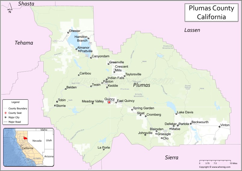
About Plumas County Map, California: The map showing the county boundary, county seat, major cities, highways, water bodies and neighbouring counties.
Most Viewed Links
About Plumas County, California
Plumas County is a county located in the U.S. state of California. It's county seat is Quincy. As per 2020 census, the population of Plumas County is 19915 people and population density is square miles. According to the United States Census Bureau, the county has a total area of 2,554 sq mi (6,615 km2). Plumas County was established on 1854.
Plumas County is a popular tourist destination, known for its beautiful natural scenery, outdoor recreation opportunities, and historic landmarks. It is home to many lakes, rivers, and streams, including Lake Almanor, the Feather River, and the Middle Fork Feather River. The county is also home to several state and national parks, such as Plumas-Eureka State Park, Lassen Volcanic National Park, and the Tahoe National Forest.
In addition to tourism, the economy of Plumas County is largely based on timber, agriculture, and mining. The county is known for its production of timber, cattle, hay, and alfalfa. There are also several mining operations in the county, including the gold mines in the town of Quincy.
Plumas County is part of the Sierra Nevada region of California, and its geography includes mountain ranges, forests, and high-elevation lakes and meadows. The county experiences a four-season climate, with warm summers and cold winters.
Facts about Plumas County, California
| Country | United States |
| State | California |
| Region | Northern Sierra Nevada |
| County Seat | Quincy |
| Named After | Spanish word “Plumas,” meaning “feathers” (Feather River) |
| Established | 1854 |
| Organized | 1854 |
| Coordinates | 39.9957° N, 120.8297° W |
| Total Area | 2,613 sq mi |
| Land Area | 2,553 sq mi |
| Water Area | 60 sq mi |
| Population (2020) | 18,807 |
| Population Rank | One of the least populous counties in California |
| Major Communities | Quincy, Portola, Chester |
| Main Industries | Tourism, Forestry, Government Services, Outdoor Recreation |
| Major Airport | Rogers Field (Quincy Airport) |
| Time Zone | Pacific Time (UTC−08:00) |
| Known For | Plumas National Forest, Feather River, Scenic mountains, Outdoor recreation |
| Website | https://www.plumascounty.us |
Ctities and Towns in Plumas County
| City Name | Type | Population (2020) | Pop. Density | Area | Incorporated |
|---|---|---|---|---|---|
| Portola | City | 2,100 | 388.2/sq mi (149.9/km2) | 5.41 sq mi (14 km2) | May 16, 1946 |
Places to Visit in Plumas County
Top places to visit in Plumas includes Plumas-Eureka State Park, Western Pacific Railroad Museum, Lake Almanor, Plumas National Forest, The Brewing Lair, Bucks Lake, Lakes Basin Recreation Area, Plumas Pines Golf Course, Lassen Volcanic National Park, Feather River Hot Springs, Bucks Lake Wilderness, Keddie Wye, Feather River Land Trust, Williams Loop, Pacific Crest Trail - Warner Valley, Johnsville Historic Ski Bowl, Clio Trestle, Mills Peak Trail, Boiling Springs Lake, Black Mountain Lookout, Sierra Valley, Frenchman Lake, Mount Elwell, Butt Valley Reservoir, Antelope Lake, Little Grass Valley Reservoir, Mount Hough, Long Lake, Jamison Lake, Gold Lake, Lower Bucks Lake.
Highways in Plumas County
State Route 36, State Route 49, State Route 70, State Route 89, State Route 284.
Nearest Airports
Nearest airport of Plumas is Nervino Airport (IATA: NVN, FAA LID: O02).
- Alameda County Map
- Alpine County Map
- Amador County Map
- Butte County Map
- Calaveras County Map
- Colusa County Map
- Contra Costa County Map
- Del Norte County Map
- El Dorado County Map
- Fresno County Map
- Glenn County Map
- Humboldt County Map
- Imperial County Map
- Inyo County Map
- Kern County Map
- Kings County Map
- Lake County Map
- Lassen County Map
- Los Angeles County Map
- Madera County Map
- Marin County Map
- Mariposa County Map
- Mendocino County Map
- Merced County Map
- Modoc County Map
- Mono County Map
- Monterey County Map
- Napa County Map
- Nevada County Map
- Orange County Map
- Placer County Map
- Plumas County Map
- Riverside County Map
- Sacramento County Map
- San Benito County Map
- San Bernardino County Map
- San Diego County Map
- San Francisco County Map
- San Joaquin County Map
- San Luis Obispo County Map
- San Mateo County Map
- Santa Barbara County Map
- Santa Clara County Map
- Santa Cruz County Map
- Shasta County Map
- Sierra County Map
- Siskiyou County Map
- Solano County Map
- Sonoma County Map
- Stanislaus County Map
- Sutter County Map
- Tehama County Map
- Trinity County Map
- Tulare County Map
- Tuolumne County Map
- Ventura County Map
- Yolo County Map
- Yuba County Map
- Alabama Counties
- Alaska boroughs
- Arizona Counties
- Arkansas Counties
- California County Map
- Colorado Counties
- Connecticut Counties
- Delaware Counties
- Florida County Map
- Georgia County Map
- Hawaii Counties
- Idaho Counties
- Illinois Counties
- Indiana Counties
- Iowa Counties
- Kansas Counties
- Kentucky Counties
- Louisiana Counties
- Maine Counties
- Maryland Counties
- Massachusetts Counties
- Michigan County Map
- Minnesota Counties
- Mississippi Counties
- Missouri Counties
- Montana Counties
- Nebraska Counties
- Nevada Counties
- New York Counties
- New Hampshire Counties
- New Jersey Counties
- New Mexico Counties
- North Carolina Counties
- North Dakota Counties
- Ohio County Map
- Oklahoma Counties
- Oregon Counties
- Pennsylvania Counties
- Rhode Island Counties
- South Carolina Counties
- South Dakota Counties
- Map of Tennessee
- Texas County Map
- Utah Counties
- Vermont Counties
- Virginia Counties
- Washington Counties
- West Virginia Counties
- Wisconsin Counties
- Wyoming Counties