Written and fact-checked by Whereig.com Web Team | Last Updated: December 16, 2025, 14:30 ET
Map of Tulare County - Tulare County is a county located in the U.S. state of California. Tulare County Map showing cities, highways, important places and water bodies. Get Where is Tulare County located in the map, major cities in Tulare county, population, areas, and places of interest.
Tulare County Map, California
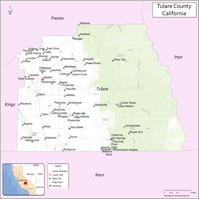
About Tulare County Map, California: The map showing the county boundary, county seat, major cities, highways, water bodies and neighbouring counties.
Most Viewed Links
About Tulare County, California
Tulare County is a county located in the San Joaquin Valley region of California, United States. The county seat and largest city is Visalia. According to the United States Census Bureau, the county has a total area of 4,840 square miles (12,539 km²), of which 4,821 square miles (12,492 km²) is land and 19 square miles (47 km²) (0.4%) is water.
It's county seat is Visalia. As per 2020 census, the population of Tulare County is 477054 people and population density is square miles. According to the United States Census Bureau, the county has a total area of 4,824 sq mi (12,494 km2). Tulare County was established on 1852. The county is known for its agriculture, with crops such as dairy products, oranges, grapes, and nuts being among the top products grown in the area.
Major cities and towns in Tulare County include Visalia, Porterville, and Tulare. The county is bordered by Fresno County to the north, Kings County to the west, Kern County to the south, and Inyo County and Mono County to the east. The eastern part of the county is home to Sequoia National Park, a popular destination for hiking and camping.
Facts about Tulare County, California
| Country | United States |
| State | California |
| Region | Central California (San Joaquin Valley & Sierra Nevada) |
| County Seat | Visalia |
| Named After | Tulare Lake (from Spanish “tular,” meaning bulrush) |
| Established | 1852 |
| Organized | 1852 |
| Coordinates | 36.2206° N, 118.8003° W |
| Total Area | 4,824 sq mi |
| Land Area | 4,824 sq mi |
| Water Area | 0 sq mi |
| Population (2020) | 466,195 |
| Population Rank | Mid-sized county in California |
| Major Cities | Visalia, Tulare, Porterville, Dinuba |
| Main Industries | Agriculture, Food Processing, Dairy Production, Government Services |
| Major Airport | Visalia Municipal Airport |
| Time Zone | Pacific Time (UTC−08:00) |
| Known For | Agricultural production, Sequoia & Kings Canyon National Parks (part), San Joaquin Valley farming |
| Website | https://www.co.tulare.ca.us |
Ctities in Tulare county County
| City Name | Type | Population (2020) | Pop. Density | Area | Incorporated |
|---|---|---|---|---|---|
| Dinuba | City | 24,563 | 3,773.1/sq mi (1,456.8/km2) | 6.51 sq mi (16.9 km2) | January 6, 1906 |
| Exeter | City | 10,321 | 4,195.5/sq mi (1,619.9/km2) | 2.46 sq mi (6.4 km2) | March 2, 1911 |
| Farmersville | City | 10,397 | 4,725.9/sq mi (1,824.7/km2) | 2.2 sq mi (5.7 km2) | October 5, 1960 |
| Lindsay | City | 12,659 | 4,654.0/sq mi (1,796.9/km2) | 2.72 sq mi (7 km2) | February 28, 1910 |
| Porterville | City | 62,623 | 3,357.8/sq mi (1,296.5/km2) | 18.65 sq mi (48.3 km2) | May 7, 1902 |
| Tulare | City | 68,875 | 3,377.9/sq mi (1,304.2/km2) | 20.39 sq mi (52.8 km2) | April 5, 1888 |
| Visalia | City | 141,384 | 3,726.5/sq mi (1,438.8/km2) | 37.94 sq mi (98.3 km2) | February 27, 1874 |
| Woodlake | City | 7,419 | 2,842.5/sq mi (1,097.5/km2) | 2.61 sq mi (6.8 km2) | September 23, 1941 |
Places to Visit in Tulare County
Top places to visit in Tulare includes Sequoia National Park, Tulare Golf Course, Del Lago Park, General Sherman Tree, Quality Inn, Moro Rock Trail, Giant Forest Museum, Yosemite Mountain Sugar, Roller Towne, Mountain Descents, General Grant Grove, Generals Highway, Quail Run Ranch.
Highways in Tulare County
State Route 43, State Route 63, State Route 65, State Route 99, State Route 137, State Route 180, State Route 190, State Route 198, State Route 201, State Route 216, State Route 245.
Nearest Airports
Nearest airport of Tulare are Porterville Municipal Airport, Visalia Municipal Airport, Meadows Field Airport, Yosemite International Airport.
- Alameda County Map
- Alpine County Map
- Amador County Map
- Butte County Map
- Calaveras County Map
- Colusa County Map
- Contra Costa County Map
- Del Norte County Map
- El Dorado County Map
- Fresno County Map
- Glenn County Map
- Humboldt County Map
- Imperial County Map
- Inyo County Map
- Kern County Map
- Kings County Map
- Lake County Map
- Lassen County Map
- Los Angeles County Map
- Madera County Map
- Marin County Map
- Mariposa County Map
- Mendocino County Map
- Merced County Map
- Modoc County Map
- Mono County Map
- Monterey County Map
- Napa County Map
- Nevada County Map
- Orange County Map
- Placer County Map
- Plumas County Map
- Riverside County Map
- Sacramento County Map
- San Benito County Map
- San Bernardino County Map
- San Diego County Map
- San Francisco County Map
- San Joaquin County Map
- San Luis Obispo County Map
- San Mateo County Map
- Santa Barbara County Map
- Santa Clara County Map
- Santa Cruz County Map
- Shasta County Map
- Sierra County Map
- Siskiyou County Map
- Solano County Map
- Sonoma County Map
- Stanislaus County Map
- Sutter County Map
- Tehama County Map
- Trinity County Map
- Tulare County Map
- Tuolumne County Map
- Ventura County Map
- Yolo County Map
- Yuba County Map
- Alabama Counties
- Alaska boroughs
- Arizona Counties
- Arkansas Counties
- California County Map
- Colorado Counties
- Connecticut Counties
- Delaware Counties
- Florida County Map
- Georgia County Map
- Hawaii Counties
- Idaho Counties
- Illinois Counties
- Indiana Counties
- Iowa Counties
- Kansas Counties
- Kentucky Counties
- Louisiana Counties
- Maine Counties
- Maryland Counties
- Massachusetts Counties
- Michigan County Map
- Minnesota Counties
- Mississippi Counties
- Missouri Counties
- Montana Counties
- Nebraska Counties
- Nevada Counties
- New York Counties
- New Hampshire Counties
- New Jersey Counties
- New Mexico Counties
- North Carolina Counties
- North Dakota Counties
- Ohio County Map
- Oklahoma Counties
- Oregon Counties
- Pennsylvania Counties
- Rhode Island Counties
- South Carolina Counties
- South Dakota Counties
- Map of Tennessee
- Texas County Map
- Utah Counties
- Vermont Counties
- Virginia Counties
- Washington Counties
- West Virginia Counties
- Wisconsin Counties
- Wyoming Counties