Written and fact-checked by Whereig.com Web Team | Last Updated: December 16, 2025, 14:30 ET
Map of Tuolumne County - Tuolumne County is a county located in the U.S. state of California. Tuolumne County Map showing cities, highways, important places and water bodies. Get Where is Tuolumne County located in the map, major cities in Tuolumne county, population, areas, and places of interest.
Tuolumne County Map, California
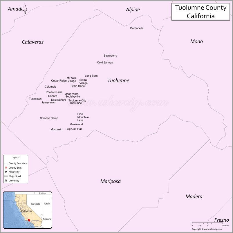
About Tuolumne County Map, California: The map showing the county boundary, county seat, major cities, highways, water bodies and neighbouring counties.
Most Viewed Links
About Tuolumne County, California
Tuolumne County is a county located in the Sierra Nevada region of California, United States. The county seat and largest city is Sonora. According to the United States Census Bureau, the county has a total area of 2,236 square miles (5,794 km²), of which 2,221 square miles (5,754 km²) is land and 14 square miles (36 km²) (0.6%) is water.
It's county seat is Sonora. As per 2020 census, the population of Tuolumne County is 55810 people and population density is square miles. According to the United States Census Bureau, the county has a total area of 2,236 sq mi (5,791 km2). Tuolumne County was established on 1850. The county is known for its natural beauty, including Yosemite National Park, a popular destination for hiking and camping. The area is also known for its gold rush history, with many historic sites and museums throughout the county.
Major cities and towns in Tuolumne County include Sonora, Twain Harte, and Jamestown. The county is bordered by Calaveras County to the north, Alpine County and Mono County to the east, Mariposa County to the south, and Stanislaus County and San Joaquin County to the west. The western part of the county is home to the Stanislaus National Forest, a popular destination for outdoor recreation.
Facts about Tuolumne County, California
| Country | United States |
| State | California |
| Region | Sierra Nevada foothills & mountains |
| County Seat | Sonora |
| Named After | Tuolumne River (name of Native American origin) |
| Established | 1850 |
| Organized | 1850 |
| Coordinates | 37.9810° N, 120.2636° W |
| Total Area | 2,274 sq mi |
| Land Area | 2,221 sq mi |
| Water Area | 53 sq mi |
| Population (2020) | 54,478 |
| Population Rank | Small-to-mid-sized county in California |
| Major Communities | Sonora, Twain Harte, Groveland |
| Main Industries | Tourism, Government Services, Healthcare, Outdoor Recreation |
| Major Airport | Columbia Airport |
| Time Zone | Pacific Time (UTC−08:00) |
| Known For | Gold Rush history, Yosemite National Park (part), Sierra Nevada scenery |
| Website | https://www.tuolumnecounty.ca.gov |
Ctities in Tuolumne county County
| City Name | Type | Population (2020) | Pop. Density | Area | Incorporated |
|---|---|---|---|---|---|
| Sonora | City | 5,003 | 1,583.2/sq mi (611.3/km2) | 3.16 sq mi (8.2 km2) | May 1, 1851 |
Places to Visit in Tuolumne County
Top places to visit in Tuolumne includes Columbia State Historic Park, Railtown 1897 State Historic, Emigrant Wilderness, Columbia, Jamestown.
Highways in Tuolumne County
State Route 49, State Route 108, California State Route 120.
Nearest Airports
Nearest airport of Tuolumne are Columbia Airport , Pine Mountain Lake Airport.
- Alameda County Map
- Alpine County Map
- Amador County Map
- Butte County Map
- Calaveras County Map
- Colusa County Map
- Contra Costa County Map
- Del Norte County Map
- El Dorado County Map
- Fresno County Map
- Glenn County Map
- Humboldt County Map
- Imperial County Map
- Inyo County Map
- Kern County Map
- Kings County Map
- Lake County Map
- Lassen County Map
- Los Angeles County Map
- Madera County Map
- Marin County Map
- Mariposa County Map
- Mendocino County Map
- Merced County Map
- Modoc County Map
- Mono County Map
- Monterey County Map
- Napa County Map
- Nevada County Map
- Orange County Map
- Placer County Map
- Plumas County Map
- Riverside County Map
- Sacramento County Map
- San Benito County Map
- San Bernardino County Map
- San Diego County Map
- San Francisco County Map
- San Joaquin County Map
- San Luis Obispo County Map
- San Mateo County Map
- Santa Barbara County Map
- Santa Clara County Map
- Santa Cruz County Map
- Shasta County Map
- Sierra County Map
- Siskiyou County Map
- Solano County Map
- Sonoma County Map
- Stanislaus County Map
- Sutter County Map
- Tehama County Map
- Trinity County Map
- Tulare County Map
- Tuolumne County Map
- Ventura County Map
- Yolo County Map
- Yuba County Map
- Alabama Counties
- Alaska boroughs
- Arizona Counties
- Arkansas Counties
- California County Map
- Colorado Counties
- Connecticut Counties
- Delaware Counties
- Florida County Map
- Georgia County Map
- Hawaii Counties
- Idaho Counties
- Illinois Counties
- Indiana Counties
- Iowa Counties
- Kansas Counties
- Kentucky Counties
- Louisiana Counties
- Maine Counties
- Maryland Counties
- Massachusetts Counties
- Michigan County Map
- Minnesota Counties
- Mississippi Counties
- Missouri Counties
- Montana Counties
- Nebraska Counties
- Nevada Counties
- New York Counties
- New Hampshire Counties
- New Jersey Counties
- New Mexico Counties
- North Carolina Counties
- North Dakota Counties
- Ohio County Map
- Oklahoma Counties
- Oregon Counties
- Pennsylvania Counties
- Rhode Island Counties
- South Carolina Counties
- South Dakota Counties
- Map of Tennessee
- Texas County Map
- Utah Counties
- Vermont Counties
- Virginia Counties
- Washington Counties
- West Virginia Counties
- Wisconsin Counties
- Wyoming Counties