Written and fact-checked by Whereig.com Web Team | Last Updated: December 16, 2025, 14:30 ET
Map of Sacramento County - Sacramento County is a county located in the U.S. state of California. Sacramento County Map showing cities, highways, important places and water bodies. Get Where is Sacramento County located in the map, major cities in Sacramento county, population, areas, and places of interest.
Sacramento County Map, California
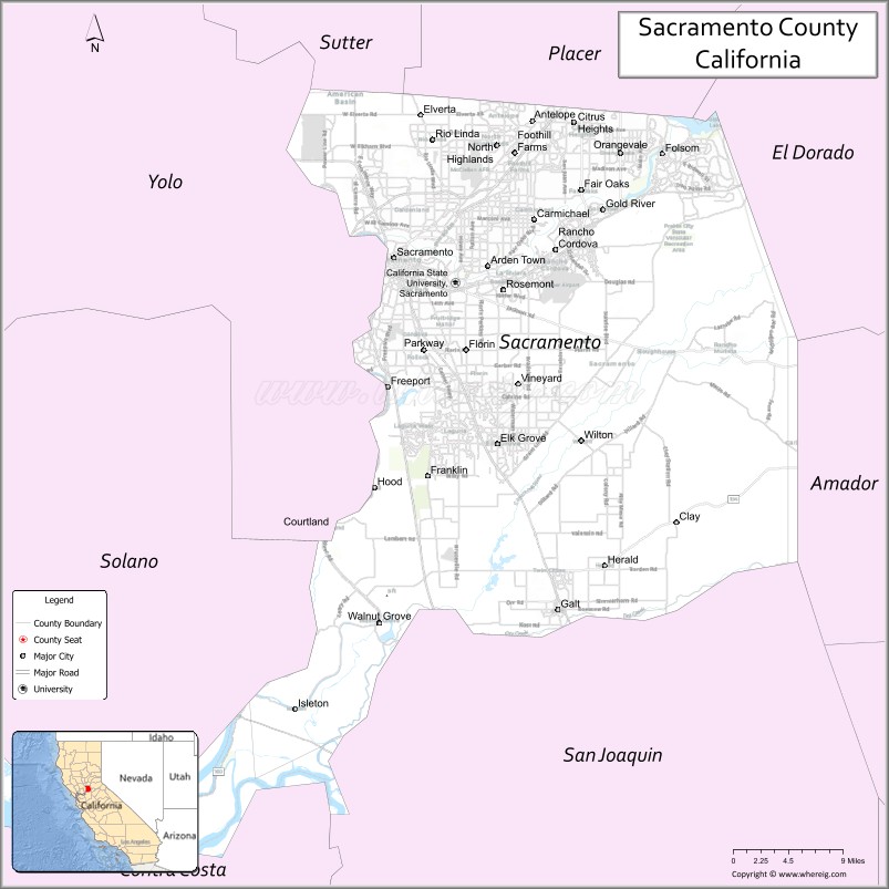
About Sacramento County Map, California: The map showing the county boundary, county seat, major cities, highways, water bodies and neighbouring counties.
Most Viewed Links
About Sacramento County, California
Sacramento County is a county located in Northern California, with its county seat in the city of Sacramento, which is also the capital of the state of California. The county has an estimated population of over 1.5 million people as of 2021.According to the United States Census Bureau, the county has a total area of 966 sq mi (2,502 km2). Sacramento County was established on 1850.
Sacramento County is known for its historic landmarks, including the California State Capitol, the Governor's Mansion, and the Sutter's Fort State Historic Park. The county is also home to several universities and colleges, including California State University, Sacramento, and the University of California, Davis.
Economically, Sacramento County is driven by a mix of industries, including government, healthcare, education, agriculture, and technology. The county is also a major transportation hub for the state, with Sacramento International Airport and several major highways and railways passing through the area.
Sacramento County is also known for its natural beauty, including the American River Parkway, which is a popular destination for outdoor recreation, such as hiking, biking, and fishing.
Facts about Sacramento County, California
| Country | United States |
| State | California |
| Region | Northern California (Sacramento Valley) |
| County Seat | Sacramento |
| Named After | Sacramento River (Spanish for “Holy Sacrament”) |
| Established | 1850 |
| Organized | 1850 |
| Coordinates | 38.4500° N, 121.3400° W |
| Total Area | 994 sq mi |
| Land Area | 965 sq mi |
| Water Area | 29 sq mi |
| Population (2020) | 1,585,055 |
| Population Rank | One of the most populous counties in California |
| Major Cities | Sacramento, Elk Grove, Folsom, Rancho Cordova |
| Main Industries | Government, Healthcare, Education, Technology, Logistics |
| Major Airport | Sacramento International Airport |
| Time Zone | Pacific Time (UTC−08:00) |
| Known For | California state capital, Government center, Sacramento River, Gold Rush history |
| Website | https://www.saccounty.gov |
Ctities and Towns in Sacramento County
| City Name | Type | Population (2020) | Pop. Density | Area | Incorporated |
|---|---|---|---|---|---|
| Citrus Heights | City | 87,583 | 6,159.1/sq mi (2,378.1/km2) | 14.22 sq mi (36.8 km2) | January 1, 1997 |
| Elk Grove | City | 176,124 | 4,194.4/sq mi (1,619.5/km2) | 41.99 sq mi (108.8 km2) | July 1, 2000 |
| Folsom | City | 80,454 | 2,885.7/sq mi (1,114.2/km2) | 27.88 sq mi (72.2 km2) | April 20, 1946 |
| Galt | City | 25,383 | 3,550.1/sq mi (1,370.7/km2) | 7.15 sq mi (18.5 km2) | August 16, 1946 |
| Isleton | City | 794 | 1,804.5/sq mi (696.7/km2) | 0.44 sq mi (1.1 km2) | May 14, 1923 |
| Rancho Cordova | City | 79,332 | 2,294.8/sq mi (886.0/km2) | 34.57 sq mi (89.5 km2) | July 1, 2003 |
| Sacramento | City | 524,943 | 5,323.4/sq mi (2,055.4/km2) | 98.61 sq mi (255.4 km2) | February 27, 1850 |
Places to Visit in Sacramento County
Top places to visit in Sacramento includes California State Capitol Museum, Crocker Art Museum, Sacramento Zoo, McKinley Park, Sutter's Fort State Historic, Tower Bridge, State Indian Museum, Discovery Park, Midtown, State Capitol Park World Peace, American River, Curtis Park, American River Parkway, Jedediah Smith Memorial Trail, Haggin Oaks Golf Complex, Folsom Lake State Recreation, River Walk Park, Sand Cove Park, Guy West Bridge.
Highways in Sacramento County
I-5, I-80, I-80 BL, US 50, SR 12, SR 16, SR 84, SR 99, SR 104, SR 160, SR 220, SR 275.
Nearest Airports
Nearest airport of Sacramento is Sacramento International Airport.
- Alameda County Map
- Alpine County Map
- Amador County Map
- Butte County Map
- Calaveras County Map
- Colusa County Map
- Contra Costa County Map
- Del Norte County Map
- El Dorado County Map
- Fresno County Map
- Glenn County Map
- Humboldt County Map
- Imperial County Map
- Inyo County Map
- Kern County Map
- Kings County Map
- Lake County Map
- Lassen County Map
- Los Angeles County Map
- Madera County Map
- Marin County Map
- Mariposa County Map
- Mendocino County Map
- Merced County Map
- Modoc County Map
- Mono County Map
- Monterey County Map
- Napa County Map
- Nevada County Map
- Orange County Map
- Placer County Map
- Plumas County Map
- Riverside County Map
- Sacramento County Map
- San Benito County Map
- San Bernardino County Map
- San Diego County Map
- San Francisco County Map
- San Joaquin County Map
- San Luis Obispo County Map
- San Mateo County Map
- Santa Barbara County Map
- Santa Clara County Map
- Santa Cruz County Map
- Shasta County Map
- Sierra County Map
- Siskiyou County Map
- Solano County Map
- Sonoma County Map
- Stanislaus County Map
- Sutter County Map
- Tehama County Map
- Trinity County Map
- Tulare County Map
- Tuolumne County Map
- Ventura County Map
- Yolo County Map
- Yuba County Map
- Alabama Counties
- Alaska boroughs
- Arizona Counties
- Arkansas Counties
- California County Map
- Colorado Counties
- Connecticut Counties
- Delaware Counties
- Florida County Map
- Georgia County Map
- Hawaii Counties
- Idaho Counties
- Illinois Counties
- Indiana Counties
- Iowa Counties
- Kansas Counties
- Kentucky Counties
- Louisiana Counties
- Maine Counties
- Maryland Counties
- Massachusetts Counties
- Michigan County Map
- Minnesota Counties
- Mississippi Counties
- Missouri Counties
- Montana Counties
- Nebraska Counties
- Nevada Counties
- New York Counties
- New Hampshire Counties
- New Jersey Counties
- New Mexico Counties
- North Carolina Counties
- North Dakota Counties
- Ohio County Map
- Oklahoma Counties
- Oregon Counties
- Pennsylvania Counties
- Rhode Island Counties
- South Carolina Counties
- South Dakota Counties
- Map of Tennessee
- Texas County Map
- Utah Counties
- Vermont Counties
- Virginia Counties
- Washington Counties
- West Virginia Counties
- Wisconsin Counties
- Wyoming Counties