Written and fact-checked by Whereig.com Web Team | Last Updated: December 16, 2025, 14:30 ET
Map of Mono County - Mono County is a county located in the U.S. state of California. Mono County Map showing cities, highways, important places and water bodies. Get Where is Mono County located in the map, major cities in Mono county, population, areas, and places of interest.
Mono County Map, California
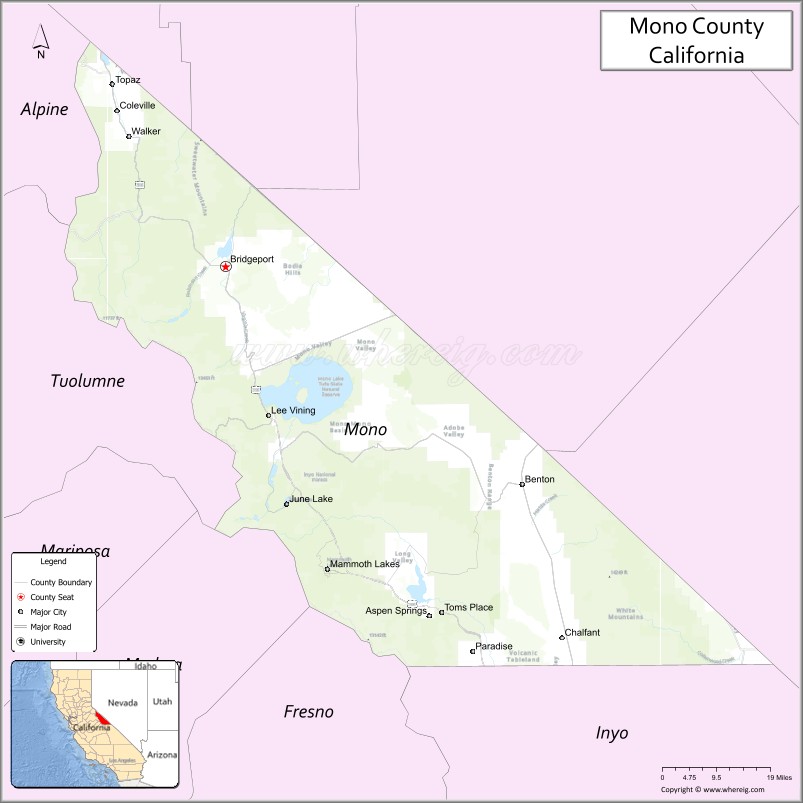
About Mono County Map, California: The map showing the county boundary, county seat, major cities, highways, water bodies and neighbouring counties.
Most Viewed Links
About Mono County, California
Mono County is a county located in the eastern part of the state of California, USA. It is situated in the Sierra Nevada region and covers an area of approximately 3,132 square miles (8,114 square kilometers). As of the 2020 Census, the population of Mono County was estimated to be around 14,350 people.Mono County was established on 1861.
The county seat and largest city in Mono County is Bridgeport. Other communities in the county include Mammoth Lakes, June Lake, Lee Vining, and Benton.
Mono County is known for its natural beauty and outdoor recreational opportunities, including skiing and snowboarding at Mammoth Mountain, fishing in the many streams and lakes, hiking and camping in the Sierra Nevada mountains, and exploring the unique geological formations of Mono Lake.
The economy of Mono County is largely driven by tourism, with a significant portion of the workforce employed in the hospitality industry. The county is also home to several research facilities, including the Mono Lake Committee and the University of California White Mountain Research Center
Facts about Mono County, California
| Country | United States |
| State | California |
| Region | Eastern California (Sierra Nevada & Great Basin) |
| County Seat | Bridgeport |
| Named After | Mono Lake and the Mono Native American tribe |
| Established | 1861 |
| Organized | 1861 |
| Coordinates | 38.0217° N, 118.1706° W |
| Total Area | 3,049 sq mi |
| Land Area | 3,039 sq mi |
| Water Area | 10 sq mi |
| Population (2020) | 13,195 |
| Population Rank | One of the least populous counties in California |
| Major Communities | Mammoth Lakes, Bridgeport |
| Main Industries | Tourism, Outdoor Recreation, Government Services |
| Major Airport | Mammoth Yosemite Airport |
| Time Zone | Pacific Time (UTC−08:00) |
| Known For | Mono Lake, Mammoth Mountain, Yosemite National Park (eastern access), Volcanic landscapes |
| Website | https://www.monocounty.ca.gov |
Ctities and Towns in Mono County
| City Name | Type | Population (2020) | Pop. Density | Area | Incorporated |
|---|---|---|---|---|---|
| Mammoth Lakes | Town | 7,191 | 289.1/sq mi (111.6/km2) | 24.87 sq mi (64.4 km2) | August 20, 1984 |
Places to Visit in Mono County
Top places to visit in Mono includes Mammoth Mountain Ski, Bodie State Historic Park, Mono Basin Scenic Area, Mono Lake Tufa State Natural, June Mountain Ski Area, Tioga Pass, Mono Mills, Mammoth Mountain, Convict Lake, Mono Lake Tufa State Natural, Patriarch Grove, Parker Lake Trailhead, Crystal Lake, Convict Lake, Sherwin Lakes Trailhead, Sierra Star Golf Course, Travertine Hot Springs, .
Highways in Mono County
U.S. Route 6, US 395, U.S. Route 395, State Route 89, State Route 108, State Route 120, State Route 158, State Route 167, State Route 168, State Route 182, State Route 203, State Route 266, State Route 270.
Nearest Airports
Nearest airport of Mono is Mammoth Yosemite Airport (MMH / KMMH).
- Alameda County Map
- Alpine County Map
- Amador County Map
- Butte County Map
- Calaveras County Map
- Colusa County Map
- Contra Costa County Map
- Del Norte County Map
- El Dorado County Map
- Fresno County Map
- Glenn County Map
- Humboldt County Map
- Imperial County Map
- Inyo County Map
- Kern County Map
- Kings County Map
- Lake County Map
- Lassen County Map
- Los Angeles County Map
- Madera County Map
- Marin County Map
- Mariposa County Map
- Mendocino County Map
- Merced County Map
- Modoc County Map
- Mono County Map
- Monterey County Map
- Napa County Map
- Nevada County Map
- Orange County Map
- Placer County Map
- Plumas County Map
- Riverside County Map
- Sacramento County Map
- San Benito County Map
- San Bernardino County Map
- San Diego County Map
- San Francisco County Map
- San Joaquin County Map
- San Luis Obispo County Map
- San Mateo County Map
- Santa Barbara County Map
- Santa Clara County Map
- Santa Cruz County Map
- Shasta County Map
- Sierra County Map
- Siskiyou County Map
- Solano County Map
- Sonoma County Map
- Stanislaus County Map
- Sutter County Map
- Tehama County Map
- Trinity County Map
- Tulare County Map
- Tuolumne County Map
- Ventura County Map
- Yolo County Map
- Yuba County Map
- Alabama Counties
- Alaska boroughs
- Arizona Counties
- Arkansas Counties
- California County Map
- Colorado Counties
- Connecticut Counties
- Delaware Counties
- Florida County Map
- Georgia County Map
- Hawaii Counties
- Idaho Counties
- Illinois Counties
- Indiana Counties
- Iowa Counties
- Kansas Counties
- Kentucky Counties
- Louisiana Counties
- Maine Counties
- Maryland Counties
- Massachusetts Counties
- Michigan County Map
- Minnesota Counties
- Mississippi Counties
- Missouri Counties
- Montana Counties
- Nebraska Counties
- Nevada Counties
- New York Counties
- New Hampshire Counties
- New Jersey Counties
- New Mexico Counties
- North Carolina Counties
- North Dakota Counties
- Ohio County Map
- Oklahoma Counties
- Oregon Counties
- Pennsylvania Counties
- Rhode Island Counties
- South Carolina Counties
- South Dakota Counties
- Map of Tennessee
- Texas County Map
- Utah Counties
- Vermont Counties
- Virginia Counties
- Washington Counties
- West Virginia Counties
- Wisconsin Counties
- Wyoming Counties