Written and fact-checked by Whereig.com Web Team | Last Updated: December 16, 2025, 14:30 ET
Map of Santa Cruz County - Santa Cruz County is a county located in the U.S. state of California. Santa Cruz County Map showing cities, highways, important places and water bodies. Get Where is Santa Cruz County located in the map, major cities in Santa Cruz county, population, areas, and places of interest.
Santa Cruz County Map, California
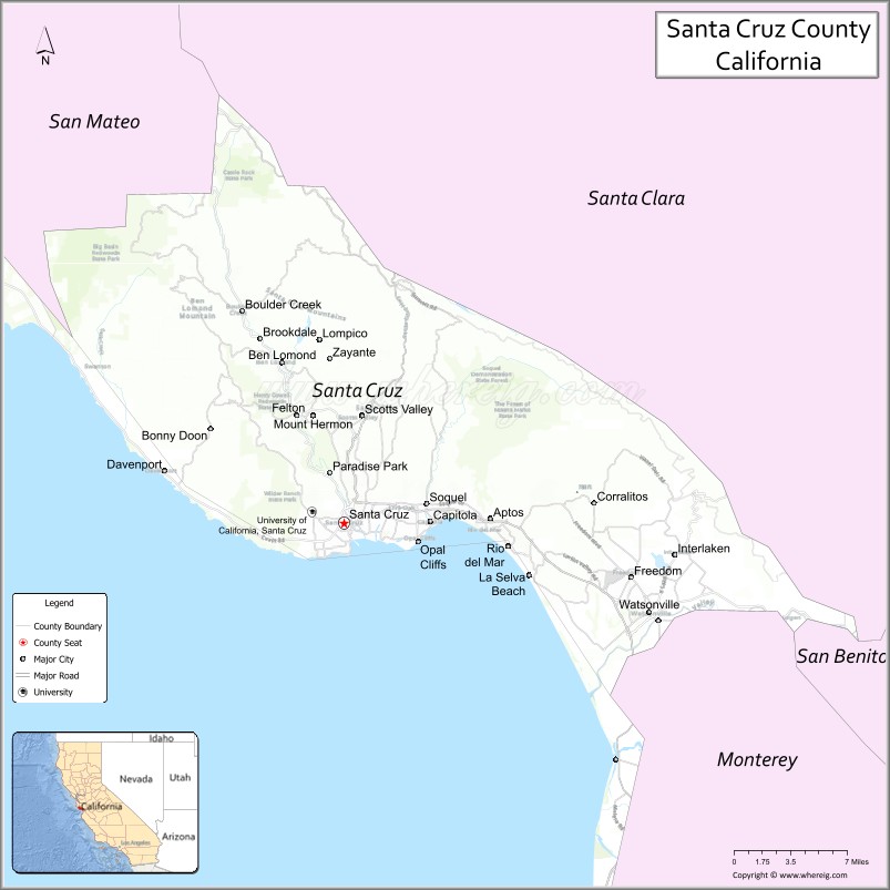
About Santa Cruz County Map, California: The map showing the county boundary, county seat, major cities, highways, water bodies and neighbouring counties.
Most Viewed Links
About Santa Cruz County, California
Santa Cruz County is a county located on the central coast of California, with its county seat in the city of Santa Cruz. The county has an estimated population of over 274,000 people as of 2021.According to the United States Census Bureau, the county has a total area of 446 sq mi (1,155 km2). Santa Cruz County was established on 1850.
Santa Cruz County is known for its scenic coastline, redwood forests, and eclectic culture. Some of the popular destinations in the county include the Santa Cruz Beach Boardwalk, Natural Bridges State Beach, and the Big Basin Redwoods State Park.
The county's economy is driven by a mix of industries, including tourism, agriculture, healthcare, and education. Santa Cruz County is home to several prestigious universities and colleges, including the University of California, Santa Cruz and Cabrillo College.
Santa Cruz County is committed to sustainability and environmental protection, with several initiatives aimed at reducing greenhouse gas emissions, promoting clean energy, and protecting natural resources. The county is also known for its vibrant arts and culture scene, with numerous galleries, music venues, and cultural festivals.
Overall, Santa Cruz County offers a laid-back lifestyle with a mix of natural beauty, cultural offerings, and economic opportunities. The county's commitment to sustainability and social justice, coupled with its diverse and thriving economy, make it a desirable place to live and visit.
Facts about Santa Cruz County, California
| Country | United States |
| State | California |
| Region | Central Coast California |
| County Seat | Santa Cruz |
| Named After | Mission Santa Cruz |
| Established | 1850 |
| Organized | 1850 |
| Coordinates | 36.9741° N, 122.0308° W |
| Total Area | 607 sq mi |
| Land Area | 446 sq mi |
| Water Area | 161 sq mi |
| Population (2020) | 270,861 |
| Population Rank | Mid-sized county in California |
| Major Cities | Santa Cruz, Watsonville, Scotts Valley |
| Main Industries | Tourism, Agriculture, Education, Technology |
| Major Airport | Watsonville Municipal Airport |
| Time Zone | Pacific Time (UTC−08:00) |
| Known For | Surfing culture, Santa Cruz Beach Boardwalk, Coastal redwoods, University of California, Santa Cruz |
| Website | https://www.santacruzcounty.us |
Ctities and Towns in Santa Cruz County
| City Name | Type | Population (2020) | Pop. Density | Area | Incorporated |
|---|---|---|---|---|---|
| Capitola | City | 9,938 | 6,250.3/sq mi (2,413.3/km2) | 1.59 sq mi (4.1 km2) | January 11, 1949 |
| Santa Cruz | City | 62,956 | 4,941.6/sq mi (1,908.0/km2) | 12.74 sq mi (33 km2) | March 31, 1866 |
| Scotts Valley | City | 12,224 | 2,645.9/sq mi (1,021.6/km2) | 4.62 sq mi (12 km2) | August 2, 1966 |
| Watsonville | City | 52,590 | 7,837.6/sq mi (3,026.1/km2) | 6.71 sq mi (17.4 km2) | March 30, 1868 |
Places to Visit in Santa Cruz County
Top places to visit in Santa Cruz includes Santa Cruz Beach Boardwalk, Santa Cruz Wharf, Natural Bridges State Beach, The Mystery Spot, Seymour Marine Discovery Center, Wilder Ranch State Park, West Cliff Drive, .
Highways in Santa Cruz County
State Route 1, State Route 9, State Route 17, State Route 35, State Route 129, State Route 152, State Route 236.
Nearest Airports
Nearest airport of Santa Cruz is Mineta- San Jose International Airport.
- Alameda County Map
- Alpine County Map
- Amador County Map
- Butte County Map
- Calaveras County Map
- Colusa County Map
- Contra Costa County Map
- Del Norte County Map
- El Dorado County Map
- Fresno County Map
- Glenn County Map
- Humboldt County Map
- Imperial County Map
- Inyo County Map
- Kern County Map
- Kings County Map
- Lake County Map
- Lassen County Map
- Los Angeles County Map
- Madera County Map
- Marin County Map
- Mariposa County Map
- Mendocino County Map
- Merced County Map
- Modoc County Map
- Mono County Map
- Monterey County Map
- Napa County Map
- Nevada County Map
- Orange County Map
- Placer County Map
- Plumas County Map
- Riverside County Map
- Sacramento County Map
- San Benito County Map
- San Bernardino County Map
- San Diego County Map
- San Francisco County Map
- San Joaquin County Map
- San Luis Obispo County Map
- San Mateo County Map
- Santa Barbara County Map
- Santa Clara County Map
- Santa Cruz County Map
- Shasta County Map
- Sierra County Map
- Siskiyou County Map
- Solano County Map
- Sonoma County Map
- Stanislaus County Map
- Sutter County Map
- Tehama County Map
- Trinity County Map
- Tulare County Map
- Tuolumne County Map
- Ventura County Map
- Yolo County Map
- Yuba County Map
- Alabama Counties
- Alaska boroughs
- Arizona Counties
- Arkansas Counties
- California County Map
- Colorado Counties
- Connecticut Counties
- Delaware Counties
- Florida County Map
- Georgia County Map
- Hawaii Counties
- Idaho Counties
- Illinois Counties
- Indiana Counties
- Iowa Counties
- Kansas Counties
- Kentucky Counties
- Louisiana Counties
- Maine Counties
- Maryland Counties
- Massachusetts Counties
- Michigan County Map
- Minnesota Counties
- Mississippi Counties
- Missouri Counties
- Montana Counties
- Nebraska Counties
- Nevada Counties
- New York Counties
- New Hampshire Counties
- New Jersey Counties
- New Mexico Counties
- North Carolina Counties
- North Dakota Counties
- Ohio County Map
- Oklahoma Counties
- Oregon Counties
- Pennsylvania Counties
- Rhode Island Counties
- South Carolina Counties
- South Dakota Counties
- Map of Tennessee
- Texas County Map
- Utah Counties
- Vermont Counties
- Virginia Counties
- Washington Counties
- West Virginia Counties
- Wisconsin Counties
- Wyoming Counties