Written and fact-checked by Whereig.com Web Team | Last Updated: December 16, 2025, 14:30 ET
Map of Placer County - Placer County is a county located in the U.S. state of California. Placer County Map showing cities, highways, important places and water bodies. Get Where is Placer County located in the map, major cities in Placer county, population, areas, and places of interest.
Placer County Map, California
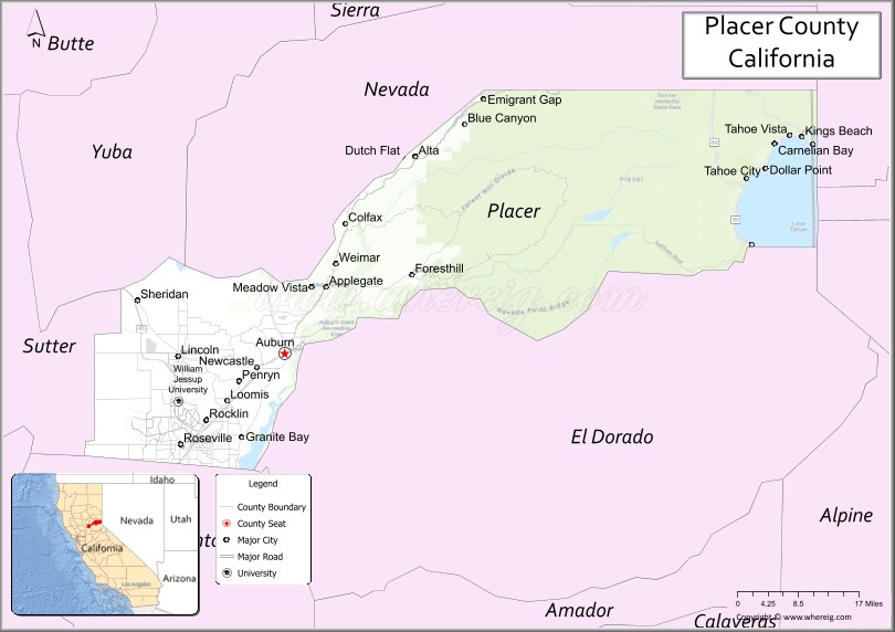
About Placer County Map, California: The map showing the county boundary, county seat, major cities, highways, water bodies and neighbouring counties.
Most Viewed Links
About Placer County, California
Placer County is a county located in the U.S. state of California. It's county seat is Auburn. As per 2020 census, the population of Placer County is 412300 people and population density is square miles. According to the United States Census Bureau, the county has a total area of 1,407 sq mi (3,644 km2). Placer County was established on 1851.
The county is known for its beautiful natural landscapes, including the Sierra Nevada mountain range, Lake Tahoe, and the American River. It is a popular destination for outdoor enthusiasts, offering activities such as skiing, hiking, fishing, and boating.
Placer County is also home to a thriving economy, with a diverse range of industries such as healthcare, technology, and agriculture. Some of the largest employers in the county include Kaiser Permanente, Sutter Health, Hewlett Packard, and Oracle.
The county seat of Placer County is Auburn, which is located in the western part of the county. Other major cities in Placer County include Roseville, Rocklin, and Lincoln.
In addition to its natural beauty and strong economy, Placer County also has a rich history dating back to the California Gold Rush of the 1850s. The county has many historical sites and museums that showcase its rich cultural heritage.
Facts about Placer County, California
| Country | United States |
| State | California |
| Region | Sierra Nevada foothills & Sacramento metropolitan area |
| County Seat | Auburn |
| Named After | Spanish word “placer,” referring to gold-bearing gravel deposits |
| Established | 1851 |
| Organized | 1851 |
| Coordinates | 39.0620° N, 120.7220° W |
| Total Area | 1,502 sq mi |
| Land Area | 1,407 sq mi |
| Water Area | 95 sq mi |
| Population (2020) | 404,739 |
| Population Rank | One of the fastest-growing counties in California |
| Major Cities | Roseville, Rocklin, Lincoln, Auburn |
| Main Industries | Technology, Healthcare, Retail, Government Services |
| Major Airport | Auburn Municipal Airport |
| Time Zone | Pacific Time (UTC−08:00) |
| Known For | Gold Rush history, Lake Tahoe (part), Suburban growth, Outdoor recreation |
| Website | https://www.placer.ca.gov |
Ctities and Towns in Placer County
| City Name | Type | Population (2020) | Pop. Density | Area | Incorporated |
|---|---|---|---|---|---|
| Auburn | City | 13,776 | 1,918.7/sq mi (740.8/km2) | 7.18 sq mi (18.6 km2) | May 2, 1888 |
| Colfax | City | 1,995 | 1,414.9/sq mi (546.3/km2) | 1.41 sq mi (3.7 km2) | February 23, 1910 |
| Lincoln | City | 49,757 | 2,058.6/sq mi (794.8/km2) | 24.17 sq mi (62.6 km2) | August 7, 1890 |
| Loomis | Town | 6,836 | 940.3/sq mi (363.1/km2) | 7.27 sq mi (18.8 km2) | December 17, 1984 |
| Rocklin | City | 71,601 | 3,614.4/sq mi (1,395.5/km2) | 19.81 sq mi (51.3 km2) | February 24, 1893 |
| Roseville | City | 147,773 | 3,352.4/sq mi (1,294.4/km2) | 44.08 sq mi (114.2 km2) | April 10, 1909 |
Places to Visit in Placer County
Top places to visit in Placer includes Palisades Tahoe, Northstar California Resort, Alpine Base Area at Palisades, Auburn State Recreation Area, Donner Memorial State Park, Hidden Falls Regional Park, Kings Beach State Recreation, Roseville Golfland, Foresthill, Lake Clementine, Commons Beach, Maidu Regional Park, Johnson-Springview Park, Lake Clementine Trail, Royal Gorge Cross Country, Eagle Rock Trailhead, Tahoe Cross-Country, Alpenglow Expeditions, North Tahoe Regional Park.
Highways in Placer County
Interstate 80, State Route 28, State Route 49, State Route 65, State Route 89, State Route 174, State Route 267.
Nearest Airports
Nearest airport of Placer is Lincoln Regional Airport.
- Alameda County Map
- Alpine County Map
- Amador County Map
- Butte County Map
- Calaveras County Map
- Colusa County Map
- Contra Costa County Map
- Del Norte County Map
- El Dorado County Map
- Fresno County Map
- Glenn County Map
- Humboldt County Map
- Imperial County Map
- Inyo County Map
- Kern County Map
- Kings County Map
- Lake County Map
- Lassen County Map
- Los Angeles County Map
- Madera County Map
- Marin County Map
- Mariposa County Map
- Mendocino County Map
- Merced County Map
- Modoc County Map
- Mono County Map
- Monterey County Map
- Napa County Map
- Nevada County Map
- Orange County Map
- Placer County Map
- Plumas County Map
- Riverside County Map
- Sacramento County Map
- San Benito County Map
- San Bernardino County Map
- San Diego County Map
- San Francisco County Map
- San Joaquin County Map
- San Luis Obispo County Map
- San Mateo County Map
- Santa Barbara County Map
- Santa Clara County Map
- Santa Cruz County Map
- Shasta County Map
- Sierra County Map
- Siskiyou County Map
- Solano County Map
- Sonoma County Map
- Stanislaus County Map
- Sutter County Map
- Tehama County Map
- Trinity County Map
- Tulare County Map
- Tuolumne County Map
- Ventura County Map
- Yolo County Map
- Yuba County Map
- Alabama Counties
- Alaska boroughs
- Arizona Counties
- Arkansas Counties
- California County Map
- Colorado Counties
- Connecticut Counties
- Delaware Counties
- Florida County Map
- Georgia County Map
- Hawaii Counties
- Idaho Counties
- Illinois Counties
- Indiana Counties
- Iowa Counties
- Kansas Counties
- Kentucky Counties
- Louisiana Counties
- Maine Counties
- Maryland Counties
- Massachusetts Counties
- Michigan County Map
- Minnesota Counties
- Mississippi Counties
- Missouri Counties
- Montana Counties
- Nebraska Counties
- Nevada Counties
- New York Counties
- New Hampshire Counties
- New Jersey Counties
- New Mexico Counties
- North Carolina Counties
- North Dakota Counties
- Ohio County Map
- Oklahoma Counties
- Oregon Counties
- Pennsylvania Counties
- Rhode Island Counties
- South Carolina Counties
- South Dakota Counties
- Map of Tennessee
- Texas County Map
- Utah Counties
- Vermont Counties
- Virginia Counties
- Washington Counties
- West Virginia Counties
- Wisconsin Counties
- Wyoming Counties