Written and fact-checked by Whereig.com Web Team | Last Updated: December 16, 2025, 14:30 ET
Map of Shasta County - Shasta County is a county located in the U.S. state of California. Shasta County Map showing cities, highways, important places and water bodies. Get Where is Shasta County located in the map, major cities in Shasta county, population, areas, and places of interest.
Shasta County Map, California
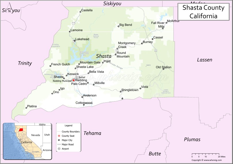
About Shasta County Map, California: The map showing the county boundary, county seat, major cities, highways, water bodies and neighbouring counties.
Most Viewed Links
About Shasta County, California
Shasta County is a county located in the U.S. state of California. It's county seat is Redding. As per 2020 census, the population of Shasta County is 182139 people and population density is square miles. According to the United States Census Bureau, the county has a total area of 3,786 sq mi (9,806 km2). Shasta County was established on 1850.
Shasta County is known for its natural beauty, with several scenic parks, lakes, and waterfalls. Some of the popular destinations in the county include the Lassen Volcanic National Park, Whiskeytown National Recreation Area, and the Shasta Dam.
The county's economy is driven by a mix of industries, including healthcare, education, and retail. The county is home to several colleges and universities, including Shasta College and Simpson University.
Shasta County is committed to sustainability and environmental protection, with several initiatives aimed at reducing greenhouse gas emissions, promoting clean energy, and protecting natural resources. The county is also known for its strong sense of community, with residents actively engaged in local politics and social issues.
Overall, Shasta County offers a high quality of life with a mix of natural beauty, economic opportunities, and community involvement. The county's commitment to sustainability and environmental protection, coupled with its diverse economy, make it a desirable place to live and visit.
Facts about Shasta County, California
| Country | United States |
| State | California |
| Region | Northern California (Shasta Cascade) |
| County Seat | Redding |
| Named After | Mount Shasta |
| Established | 1850 |
| Organized | 1850 |
| Coordinates | 40.7600° N, 122.0400° W |
| Total Area | 3,847 sq mi |
| Land Area | 3,775 sq mi |
| Water Area | 72 sq mi |
| Population (2020) | 182,155 |
| Population Rank | Mid-sized county in California |
| Major Cities | Redding, Anderson, Shasta Lake |
| Main Industries | Healthcare, Government Services, Retail, Tourism |
| Major Airport | Redding Regional Airport |
| Time Zone | Pacific Time (UTC−08:00) |
| Known For | Mount Shasta (nearby), Shasta Lake, Outdoor recreation, Scenic mountain landscapes |
| Website | https://www.co.shasta.ca.us |
Ctities and Towns in Shasta County
| City Name | Type | Population (2020) | Pop. Density | Area | Incorporated |
|---|---|---|---|---|---|
| Anderson | City | 11,323 | 1,610.7/sq mi (621.9/km2) | 7.03 sq mi (18.2 km2) | January 16, 1956 |
| Redding | City | 93,611 | 1,569.3/sq mi (605.9/km2) | 59.65 sq mi (154.5 km2) | October 4, 1887 |
| Shasta Lake | City | 10,371 | 949.7/sq mi (366.7/km2) | 10.92 sq mi (28.3 km2) | July 2, 1993 |
Places to Visit in Shasta County
Top places to visit in Shasta includes Sundial Bridge, Shasta State Historic Park, Turtle Bay Exploration Park, Lake Shasta Caverns National, Shasta Dam, Keswick Dam Trailhead Sac, Keswick Dam, Whiskeytown National, Keswick Reservoir, Iron Mountain Mine, Sacramento River Trail, Whiskeytown Visitor Center, Whiskeytown Lake, Chamise Peak, On Water Yoga.
Highways in Shasta County
Interstate 5, State Route 36, State Route 44, State Route 89, State Route 151, State Route 273, State Route 299.
Nearest Airports
Nearest airport of Shasta is Sacramento International Airport (SMF IATA).
- Alameda County Map
- Alpine County Map
- Amador County Map
- Butte County Map
- Calaveras County Map
- Colusa County Map
- Contra Costa County Map
- Del Norte County Map
- El Dorado County Map
- Fresno County Map
- Glenn County Map
- Humboldt County Map
- Imperial County Map
- Inyo County Map
- Kern County Map
- Kings County Map
- Lake County Map
- Lassen County Map
- Los Angeles County Map
- Madera County Map
- Marin County Map
- Mariposa County Map
- Mendocino County Map
- Merced County Map
- Modoc County Map
- Mono County Map
- Monterey County Map
- Napa County Map
- Nevada County Map
- Orange County Map
- Placer County Map
- Plumas County Map
- Riverside County Map
- Sacramento County Map
- San Benito County Map
- San Bernardino County Map
- San Diego County Map
- San Francisco County Map
- San Joaquin County Map
- San Luis Obispo County Map
- San Mateo County Map
- Santa Barbara County Map
- Santa Clara County Map
- Santa Cruz County Map
- Shasta County Map
- Sierra County Map
- Siskiyou County Map
- Solano County Map
- Sonoma County Map
- Stanislaus County Map
- Sutter County Map
- Tehama County Map
- Trinity County Map
- Tulare County Map
- Tuolumne County Map
- Ventura County Map
- Yolo County Map
- Yuba County Map
- Alabama Counties
- Alaska boroughs
- Arizona Counties
- Arkansas Counties
- California County Map
- Colorado Counties
- Connecticut Counties
- Delaware Counties
- Florida County Map
- Georgia County Map
- Hawaii Counties
- Idaho Counties
- Illinois Counties
- Indiana Counties
- Iowa Counties
- Kansas Counties
- Kentucky Counties
- Louisiana Counties
- Maine Counties
- Maryland Counties
- Massachusetts Counties
- Michigan County Map
- Minnesota Counties
- Mississippi Counties
- Missouri Counties
- Montana Counties
- Nebraska Counties
- Nevada Counties
- New York Counties
- New Hampshire Counties
- New Jersey Counties
- New Mexico Counties
- North Carolina Counties
- North Dakota Counties
- Ohio County Map
- Oklahoma Counties
- Oregon Counties
- Pennsylvania Counties
- Rhode Island Counties
- South Carolina Counties
- South Dakota Counties
- Map of Tennessee
- Texas County Map
- Utah Counties
- Vermont Counties
- Virginia Counties
- Washington Counties
- West Virginia Counties
- Wisconsin Counties
- Wyoming Counties