Written and fact-checked by Whereig.com Web Team | Last Updated: December 16, 2025, 14:30 ET
Map of Mendocino County - Mendocino County is a county located in the U.S. state of California. Mendocino County Map showing cities, highways, important places and water bodies. Get Where is Mendocino County located in the map, major cities in Mendocino county, population, areas, and places of interest.
Mendocino County Map, California
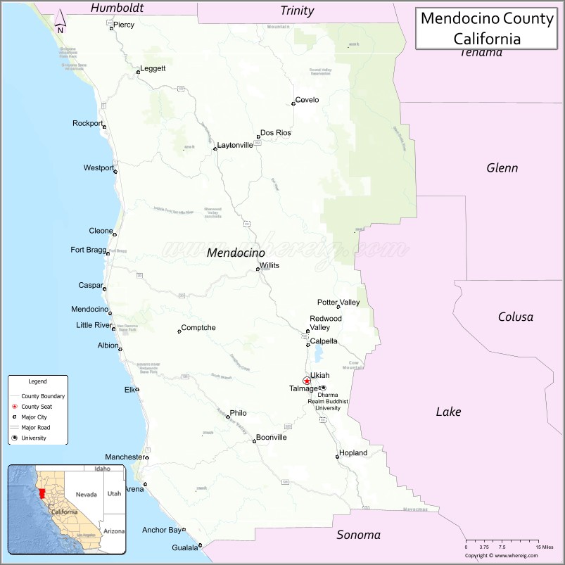
About Mendocino County Map, California: The map showing the county boundary, county seat, major cities, highways, water bodies and neighbouring counties.
Most Viewed Links
About Mendocino County, California
Mendocino County is a county located in the U.S. state of California. It's county seat is Ukiah. As per 2020 census, the population of Mendocino County is 91305 people and population density is square miles. According to the United States Census Bureau, the county has a total area of 3,509 sq mi (9,088 km2). Mendocino County was established on 1850.
Mendocino County is known for its rugged coastline, redwood forests, and vineyards. It is home to several state parks, including the Mendocino Headlands State Park, the Russian Gulch State Park, and the Van Damme State Park. The county is also home to the Mendocino Coast Botanical Gardens, which features a wide variety of plant species, including rare and endangered plants.
The county is known for its wine industry, with over 90 wineries and vineyards producing a wide variety of wines. The county is also known for its marijuana cultivation, with a large number of marijuana farms operating in the area.
Other popular attractions in Mendocino County include the Skunk Train, a historic railway that travels through the redwood forests, and the Point Arena Lighthouse, a historic lighthouse that offers stunning views of the Pacific Ocean.
Facts about Mendocino County, California
| Country | United States |
| State | California |
| Region | Northern California (North Coast) |
| County Seat | Ukiah |
| Named After | Cape Mendocino |
| Established | 1850 |
| Organized | 1850 |
| Coordinates | 39.4324° N, 123.4416° W |
| Total Area | 3,878 sq mi |
| Land Area | 3,506 sq mi |
| Water Area | 372 sq mi |
| Population (2020) | 91,601 |
| Population Rank | Small-to-mid-sized county in California |
| Major Cities | Ukiah, Fort Bragg, Willits |
| Main Industries | Agriculture, Wine Production, Forestry, Tourism |
| Major Airport | Ukiah Municipal Airport |
| Time Zone | Pacific Time (UTC−08:00) |
| Known For | Rugged Pacific coastline, Redwoods, Wine country, Scenic landscapes |
| Website | https://www.mendocinocounty.org |
Ctities and Towns in Mendocino County
| City Name | Type | Population (2020) | Pop. Density | Area | Incorporated |
|---|---|---|---|---|---|
| Fort Bragg | City | 6,983 | 2,407.9/sq mi (929.7/km2) | 2.9 sq mi (7.5 km2) | August 5, 1889 |
| Point Arena | City | 460 | 335.8/sq mi (129.6/km2) | 1.37 sq mi (3.5 km2) | July 11, 1908 |
| Ukiah | City | 16,607 | 3,474.3/sq mi (1,341.4/km2) | 4.78 sq mi (12.4 km2) | March 8, 1876 |
| Willits | City | 4,988 | 1,768.8/sq mi (682.9/km2) | 2.82 sq mi (7.3 km2) | November 19, 1888 |
Places to Visit in Mendocino County
Top places to visit in Mendocino includes Mendocino Headlands State, Russian Gulch State Park, Big River Beach at Mendocino, Van Damme State Park, Mendocino Art Center, Mendocino Jams & Preserves, Mendocino Coast Botanical, Jug Handle State Natural Reserve, Point Arena Lighthouse, Mendocino Area Parks Association, Water Gallery, Mendocino Coast Massage, Portuguese Beach, Spring Ranch Nature Preserve, Noyo Headlands Park, Point Cabrillo, Russian Gulch Bridge, Fern Canyon, Van Damme State Beach, Jug Handle Beach.
Highways in Mendocino County
State Route 1, U.S. Route 101, State Route 20, State Route 128, State Route 162, State Route 175, State Route 222, State Route 253, State Route 271.
Nearest Airports
Nearest airport of Mendocino is Mendocino County Airport.
- Alameda County Map
- Alpine County Map
- Amador County Map
- Butte County Map
- Calaveras County Map
- Colusa County Map
- Contra Costa County Map
- Del Norte County Map
- El Dorado County Map
- Fresno County Map
- Glenn County Map
- Humboldt County Map
- Imperial County Map
- Inyo County Map
- Kern County Map
- Kings County Map
- Lake County Map
- Lassen County Map
- Los Angeles County Map
- Madera County Map
- Marin County Map
- Mariposa County Map
- Mendocino County Map
- Merced County Map
- Modoc County Map
- Mono County Map
- Monterey County Map
- Napa County Map
- Nevada County Map
- Orange County Map
- Placer County Map
- Plumas County Map
- Riverside County Map
- Sacramento County Map
- San Benito County Map
- San Bernardino County Map
- San Diego County Map
- San Francisco County Map
- San Joaquin County Map
- San Luis Obispo County Map
- San Mateo County Map
- Santa Barbara County Map
- Santa Clara County Map
- Santa Cruz County Map
- Shasta County Map
- Sierra County Map
- Siskiyou County Map
- Solano County Map
- Sonoma County Map
- Stanislaus County Map
- Sutter County Map
- Tehama County Map
- Trinity County Map
- Tulare County Map
- Tuolumne County Map
- Ventura County Map
- Yolo County Map
- Yuba County Map
- Alabama Counties
- Alaska boroughs
- Arizona Counties
- Arkansas Counties
- California County Map
- Colorado Counties
- Connecticut Counties
- Delaware Counties
- Florida County Map
- Georgia County Map
- Hawaii Counties
- Idaho Counties
- Illinois Counties
- Indiana Counties
- Iowa Counties
- Kansas Counties
- Kentucky Counties
- Louisiana Counties
- Maine Counties
- Maryland Counties
- Massachusetts Counties
- Michigan County Map
- Minnesota Counties
- Mississippi Counties
- Missouri Counties
- Montana Counties
- Nebraska Counties
- Nevada Counties
- New York Counties
- New Hampshire Counties
- New Jersey Counties
- New Mexico Counties
- North Carolina Counties
- North Dakota Counties
- Ohio County Map
- Oklahoma Counties
- Oregon Counties
- Pennsylvania Counties
- Rhode Island Counties
- South Carolina Counties
- South Dakota Counties
- Map of Tennessee
- Texas County Map
- Utah Counties
- Vermont Counties
- Virginia Counties
- Washington Counties
- West Virginia Counties
- Wisconsin Counties
- Wyoming Counties