Written and fact-checked by Whereig.com Web Team | Last Updated: December 16, 2025, 14:30 ET
Map of Orange County - Orange County is a county located in the U.S. state of California. Orange County Map showing cities, highways, important places and water bodies. Get Where is Orange County located in the map, major cities in Orange county, population, areas, and places of interest.
Orange County Map, California
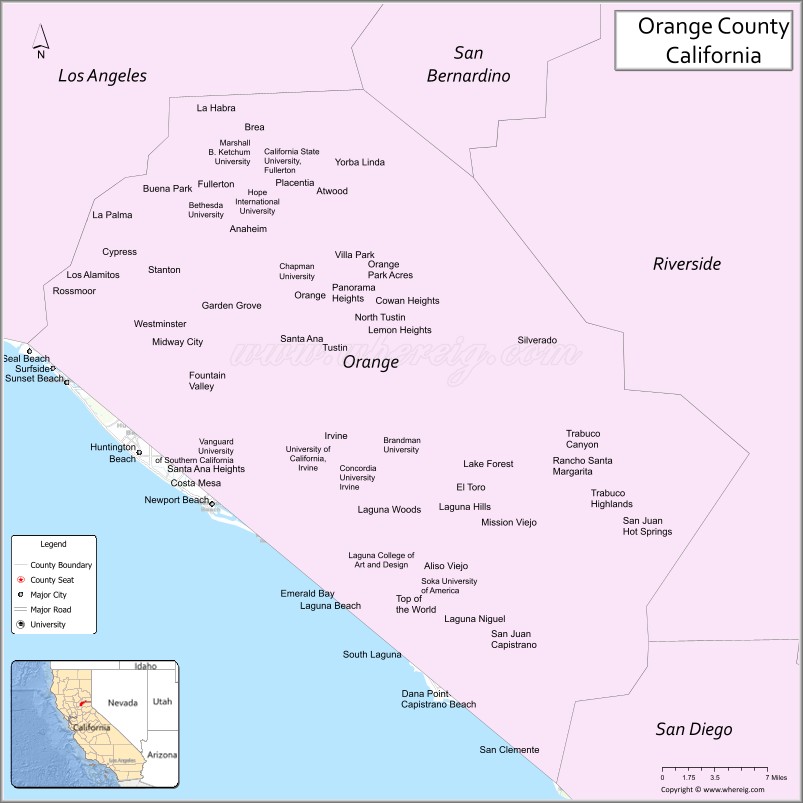
About Orange County Map, California: The map showing the county boundary, county seat, major cities, highways, water bodies and neighbouring counties.
Most Viewed Links
Map of Orange County, California
Orange County is a county located in Southern California, United States. It is the sixth most populous county in California and the 10th most populous in the United States, with an estimated population of over 3.2 million people as of 2021.Orange County was established on 1889.
The county is known for its beaches, Disneyland Resort, Knott's Berry Farm, and a wide variety of other tourist attractions. It is also home to several major universities and colleges, including the University of California, Irvine, California State University, Fullerton, Chapman University, and many more.
The county is divided into 34 incorporated cities and several unincorporated areas. The largest cities in Orange County include Anaheim, Santa Ana, Irvine, Huntington Beach, and Newport Beach.
County Seat: The county seat of Orange County is Santa Ana.
Location: Orange County is situated in Southern California, along the coast. It is known for its coastal cities, beautiful beaches, and upscale communities.
Population: As of the 2020 United States Census, the population of Orange County was over 3.2 million people, making it the sixth most populous county in the United States.
Economy: Orange County has a diverse economy, with sectors including technology, healthcare, finance, tourism, and manufacturing. It is home to many Fortune 500 companies and has a high median income.
Education: Orange County is home to several prestigious universities and colleges, including the University of California, Irvine (UCI), and Chapman University.
Attractions: Orange County is famous for its tourist attractions, including Disneyland Resort in Anaheim, Knott's Berry Farm in Buena Park, and beautiful beaches such as Huntington Beach and Laguna Beach. The county also offers a range of cultural and outdoor activities, including art galleries, theaters, and hiking trails.
Weather: Orange County enjoys a Mediterranean climate with mild, wet winters and hot, dry summers. The weather is one of the attractions, with plenty of sunny days throughout the year.
History: Orange County has a rich history, with Native American settlements predating Spanish exploration. It became a part of the United States in 1848 after the Mexican-American War.
Facts about Orange County, California
| Country | United States |
| State | California |
| Region | Southern California |
| County Seat | Santa Ana |
| Named After | Orange groves that once dominated the region |
| Established | 1889 |
| Organized | 1889 |
| Coordinates | 33.7175° N, 117.8311° W |
| Total Area | 948 sq mi |
| Land Area | 790 sq mi |
| Water Area | 158 sq mi |
| Population (2020) | 3,186,989 |
| Population Rank | One of the most populous counties in the United States |
| Major Cities | Anaheim, Irvine, Santa Ana, Huntington Beach, Newport Beach |
| Main Industries | Technology, Tourism, Healthcare, Finance, Education |
| Major Airports | John Wayne Airport, Long Beach Airport (nearby) |
| Time Zone | Pacific Time (UTC−08:00) |
| Known For | Disneyland Resort, Beaches, Master-planned communities, Technology hubs |
| Website | https://www.ocgov.com |
Ctities and Towns in Orange
| City Name | Type | Population (2020) | Pop. Density | Area | Incorporated |
|---|---|---|---|---|---|
| Aliso Viejo | City | 52,176 | 7,529.0/sq mi (2,907.0/km2) | 6.93 sq mi (17.9 km2) | July 1, 2001 |
| Anaheim | City | 346,824 | 6,899.2/sq mi (2,663.8/km2) | 50.27 sq mi (130.2 km2) | March 18, 1876 |
| Brea | City | 47,325 | 3,888.7/sq mi (1,501.4/km2) | 12.17 sq mi (31.5 km2) | February 23, 1917 |
| Buena Park | City | 84,034 | 7,980.4/sq mi (3,081.3/km2) | 10.53 sq mi (27.3 km2) | January 27, 1953 |
| Costa Mesa | City | 111,918 | 7,078.9/sq mi (2,733.2/km2) | 15.81 sq mi (40.9 km2) | June 29, 1953 |
| Cypress | City | 50,151 | 7,587.1/sq mi (2,929.4/km2) | 6.61 sq mi (17.1 km2) | July 24, 1956 |
| Dana Point | City | 33,107 | 5,101.2/sq mi (1,969.6/km2) | 6.49 sq mi (16.8 km2) | January 1, 1989 |
| Fountain Valley | City | 57,047 | 6,289.6/sq mi (2,428.4/km2) | 9.07 sq mi (23.5 km2) | June 13, 1957 |
| Fullerton | City | 143,617 | 6,405.8/sq mi (2,473.3/km2) | 22.42 sq mi (58.1 km2) | February 15, 1904 |
| Garden Grove | City | 171,949 | 9,574.0/sq mi (3,696.5/km2) | 17.96 sq mi (46.5 km2) | June 18, 1956 |
| Huntington Beach | City | 198,711 | 7,359.7/sq mi (2,841.6/km2) | 27 sq mi (69.9 km2) | February 17, 1909 |
| Irvine | City | 307,670 | 4,689.4/sq mi (1,810.6/km2) | 65.61 sq mi (169.9 km2) | December 28, 1971 |
| La Habra | City | 63,097 | 8,346.2/sq mi (3,222.5/km2) | 7.56 sq mi (19.6 km2) | January 20, 1925 |
| La Palma | City | 15,581 | 8,753.4/sq mi (3,379.7/km2) | 1.78 sq mi (4.6 km2) | October 26, 1955 |
| Laguna Beach | City | 23,032 | 2,590.8/sq mi (1,000.3/km2) | 8.89 sq mi (23 km2) | June 29, 1927 |
| Laguna Hills | City | 31,374 | 4,789.9/sq mi (1,849.4/km2) | 6.55 sq mi (17 km2) | December 20, 1991 |
| Laguna Niguel | City | 64,355 | 4,366.0/sq mi (1,685.7/km2) | 14.74 sq mi (38.2 km2) | December 1, 1989 |
| Laguna Woods | City | 17,644 | 5,282.6/sq mi (2,039.6/km2) | 3.34 sq mi (8.7 km2) | March 24, 1999 |
| Lake Forest | City | 85,858 | 5,138.1/sq mi (1,983.8/km2) | 16.71 sq mi (43.3 km2) | December 20, 1991 |
| Los Alamitos | City | 11,780 | 2,937.7/sq mi (1,134.2/km2) | 4.01 sq mi (10.4 km2) | March 1, 1960 |
| Mission Viejo | City | 93,653 | 5,303.1/sq mi (2,047.5/km2) | 17.66 sq mi (45.7 km2) | March 31, 1988 |
| Newport Beach | City | 85,239 | 3,583.0/sq mi (1,383.4/km2) | 23.79 sq mi (61.6 km2) | September 1, 1906 |
| Orange | City | 139,911 | 5,450.4/sq mi (2,104.4/km2) | 25.67 sq mi (66.5 km2) | April 6, 1888 |
| Placentia | City | 51,824 | 7,840.2/sq mi (3,027.1/km2) | 6.61 sq mi (17.1 km2) | December 2, 1926 |
| Rancho Santa Margarita | City | 47,949 | 3,717.0/sq mi (1,435.1/km2) | 12.9 sq mi (33.4 km2) | January 1, 2000 |
| San Clemente | City | 64,293 | 3,501.8/sq mi (1,352.1/km2) | 18.36 sq mi (47.6 km2) | February 28, 1928 |
| San Juan Capistrano | City | 35,196 | 2,439.1/sq mi (941.7/km2) | 14.43 sq mi (37.4 km2) | April 19, 1961 |
| Santa Ana | City | 310,227 | 11,347.0/sq mi (4,381.1/km2) | 27.34 sq mi (70.8 km2) | June 1, 1886 |
| Seal Beach | City | 25,242 | 2,239.8/sq mi (864.8/km2) | 11.27 sq mi (29.2 km2) | October 27, 1915 |
| Stanton | City | 37,962 | 12,245.8/sq mi (4,728.1/km2) | 3.1 sq mi (8 km2) | June 4, 1956 |
| Tustin | City | 80,276 | 7,193.2/sq mi (2,777.3/km2) | 11.16 sq mi (28.9 km2) | September 21, 1927 |
| Villa Park | City | 5,843 | 2,809.1/sq mi (1,084.6/km2) | 2.08 sq mi (5.4 km2) | January 11, 1962 |
| Westminster | City | 90,911 | 9,054.9/sq mi (3,496.1/km2) | 10.04 sq mi (26 km2) | March 27, 1957 |
| Yorba Linda | City | 68,336 | 3,425.4/sq mi (1,322.5/km2) | 19.95 sq mi (51.7 km2) | November 2, 1967 |
Places to Visit in Orange
Top places to visit in Orange includes Disneyland Park, Disney California Adventure Park, Irvine Regional Park, Orange County Zoo, Downtown Disney District, Knott's Berry Farm, Discovery Cube Orange County, Victoria Beach, Riverdale Park, Oak Canyon Park, Dana Point Harbor, Santiago Creek, Juarez Park, Santa Ana River Trail, .
Highways in Orange
Interstate 5, Interstate 405, Interstate 605, State Route 1, State Route 22, State Route 39, State Route 55, State Route 57, State Route 72, State Route 73, State Route 74, State Route 90, State Route 91, State Route 133, State Route 142, State Route 241, State Route 261.
Airport
Nearest airport of Orange is John Wayne Airport (JWA).
- Alameda County Map
- Alpine County Map
- Amador County Map
- Butte County Map
- Calaveras County Map
- Colusa County Map
- Contra Costa County Map
- Del Norte County Map
- El Dorado County Map
- Fresno County Map
- Glenn County Map
- Humboldt County Map
- Imperial County Map
- Inyo County Map
- Kern County Map
- Kings County Map
- Lake County Map
- Lassen County Map
- Los Angeles County Map
- Madera County Map
- Marin County Map
- Mariposa County Map
- Mendocino County Map
- Merced County Map
- Modoc County Map
- Mono County Map
- Monterey County Map
- Napa County Map
- Nevada County Map
- Orange County Map
- Placer County Map
- Plumas County Map
- Riverside County Map
- Sacramento County Map
- San Benito County Map
- San Bernardino County Map
- San Diego County Map
- San Francisco County Map
- San Joaquin County Map
- San Luis Obispo County Map
- San Mateo County Map
- Santa Barbara County Map
- Santa Clara County Map
- Santa Cruz County Map
- Shasta County Map
- Sierra County Map
- Siskiyou County Map
- Solano County Map
- Sonoma County Map
- Stanislaus County Map
- Sutter County Map
- Tehama County Map
- Trinity County Map
- Tulare County Map
- Tuolumne County Map
- Ventura County Map
- Yolo County Map
- Yuba County Map
- Alabama Counties
- Alaska boroughs
- Arizona Counties
- Arkansas Counties
- California County Map
- Colorado Counties
- Connecticut Counties
- Delaware Counties
- Florida County Map
- Georgia County Map
- Hawaii Counties
- Idaho Counties
- Illinois Counties
- Indiana Counties
- Iowa Counties
- Kansas Counties
- Kentucky Counties
- Louisiana Counties
- Maine Counties
- Maryland Counties
- Massachusetts Counties
- Michigan County Map
- Minnesota Counties
- Mississippi Counties
- Missouri Counties
- Montana Counties
- Nebraska Counties
- Nevada Counties
- New York Counties
- New Hampshire Counties
- New Jersey Counties
- New Mexico Counties
- North Carolina Counties
- North Dakota Counties
- Ohio County Map
- Oklahoma Counties
- Oregon Counties
- Pennsylvania Counties
- Rhode Island Counties
- South Carolina Counties
- South Dakota Counties
- Map of Tennessee
- Texas County Map
- Utah Counties
- Vermont Counties
- Virginia Counties
- Washington Counties
- West Virginia Counties
- Wisconsin Counties
- Wyoming Counties