Written and fact-checked by Whereig.com Web Team | Last Updated: December 16, 2025, 14:30 ET
Map of Humboldt County - Humboldt County is a county located in the U.S. state of California. Humboldt County Map showing cities, highways, important places and water bodies. Get Where is Humboldt County located in the map, major cities in Humboldt county, population, areas, and places of interest.
Humboldt County Map, California
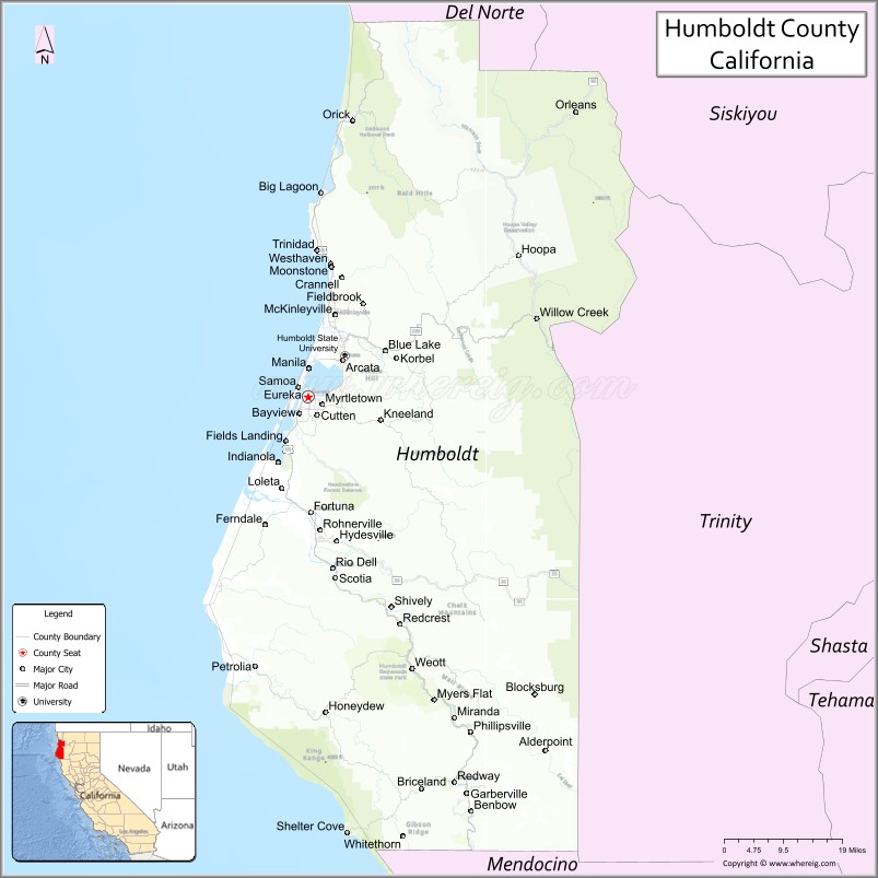
About Humboldt County Map, California: The map showing the county boundary, county seat, major cities, highways, water bodies and neighbouring counties.
Most Viewed Links
About Humboldt County, California
Humboldt County is a county located in the northwestern part of the state of California in the United States. Its county seat is Eureka. The county is known for its natural beauty, including its rugged coastline, towering redwood forests, and scenic rivers.
Humboldt County has a population of approximately 135,000 people and covers an area of about 3,573 square miles. The county is largely rural, with a number of small towns and communities scattered throughout the region. Outdoor recreational activities such as hiking, camping, fishing, and surfing are popular in the area. Humboldt County was established on 1853.
Eureka is the largest community in Humboldt County and serves as the county seat. Other communities in the county include Arcata, McKinleyville, Fortuna, and Trinidad.
Facts about Humboldt County, California
| Country | United States |
| State | California |
| Region | Northwestern California (Redwood Coast) |
| County Seat | Eureka |
| Named After | Alexander von Humboldt |
| Established | 1853 |
| Organized | 1853 |
| Coordinates | 40.7066° N, 123.9262° W |
| Total Area | 4,052 sq mi |
| Land Area | 3,568 sq mi |
| Water Area | 484 sq mi |
| Population (2020) | 136,463 |
| Population Rank | Mid-sized county in California |
| Major Cities | Eureka, Arcata, Fortuna |
| Main Industries | Forestry, Fisheries, Healthcare, Education, Tourism |
| Major Airport | California Redwood Coast–Humboldt County Airport |
| Time Zone | Pacific Time (UTC−08:00) |
| Known For | Redwood National and State Parks, Humboldt Bay, Rugged coastline, Cannabis cultivation |
| Website | https://humboldtgov.org |
Ctities and Towns in Humboldt County
| City Name | Type | Population (2020) | Pop. Density | Area | Incorporated |
|---|---|---|---|---|---|
| Arcata | City | 18,857 | 2,001.8/sq mi (772.9/km2) | 9.42 sq mi (24.4 km2) | February 2, 1858 |
| Blue Lake | City | 1,208 | 2,047.5/sq mi (790.5/km2) | 0.59 sq mi (1.5 km2) | April 23, 1910 |
| Eureka | City | 26,512 | 2,779.0/sq mi (1,073.0/km2) | 9.54 sq mi (24.7 km2) | April 18, 1856 |
| Ferndale | City | 1,398 | 1,165.0/sq mi (449.8/km2) | 1.2 sq mi (3.1 km2) | August 28, 1893 |
| Fortuna | City | 12,516 | 2,384.0/sq mi (920.5/km2) | 5.25 sq mi (13.6 km2) | January 20, 1906 |
| Rio Dell | City | 3,379 | 1,482.0/sq mi (572.2/km2) | 2.28 sq mi (5.9 km2) | February 23, 1965 |
| Trinidad | City | 307 | 626.5/sq mi (241.9/km2) | 0.49 sq mi (1.3 km2) | November 7, 1870 |
Places to Visit in Humboldt County
Top places to visit in Humboldt includes Humboldt Redwoods State, Prairie Creek Redwoods State, Sue-Meg State Park, Lady Bird Johnson Grove, Redwood National, Trinidad State Beach, Fern Canyon, Redwood Sky Walk at Sequoia.
Highways in Humboldt County
U.S. Route 101, State Route 36, State Route 96, State Route 169, State Route 200, State Route 211, State Route 254, g State Route 255, State Route 271, State Route 283, g State Route 299.
Nearest Airports
Nearest airport of Humboldt is Arcata/Eureka airport.
- Alameda County Map
- Alpine County Map
- Amador County Map
- Butte County Map
- Calaveras County Map
- Colusa County Map
- Contra Costa County Map
- Del Norte County Map
- El Dorado County Map
- Fresno County Map
- Glenn County Map
- Humboldt County Map
- Imperial County Map
- Inyo County Map
- Kern County Map
- Kings County Map
- Lake County Map
- Lassen County Map
- Los Angeles County Map
- Madera County Map
- Marin County Map
- Mariposa County Map
- Mendocino County Map
- Merced County Map
- Modoc County Map
- Mono County Map
- Monterey County Map
- Napa County Map
- Nevada County Map
- Orange County Map
- Placer County Map
- Plumas County Map
- Riverside County Map
- Sacramento County Map
- San Benito County Map
- San Bernardino County Map
- San Diego County Map
- San Francisco County Map
- San Joaquin County Map
- San Luis Obispo County Map
- San Mateo County Map
- Santa Barbara County Map
- Santa Clara County Map
- Santa Cruz County Map
- Shasta County Map
- Sierra County Map
- Siskiyou County Map
- Solano County Map
- Sonoma County Map
- Stanislaus County Map
- Sutter County Map
- Tehama County Map
- Trinity County Map
- Tulare County Map
- Tuolumne County Map
- Ventura County Map
- Yolo County Map
- Yuba County Map
- Alabama Counties
- Alaska boroughs
- Arizona Counties
- Arkansas Counties
- California County Map
- Colorado Counties
- Connecticut Counties
- Delaware Counties
- Florida County Map
- Georgia County Map
- Hawaii Counties
- Idaho Counties
- Illinois Counties
- Indiana Counties
- Iowa Counties
- Kansas Counties
- Kentucky Counties
- Louisiana Counties
- Maine Counties
- Maryland Counties
- Massachusetts Counties
- Michigan County Map
- Minnesota Counties
- Mississippi Counties
- Missouri Counties
- Montana Counties
- Nebraska Counties
- Nevada Counties
- New York Counties
- New Hampshire Counties
- New Jersey Counties
- New Mexico Counties
- North Carolina Counties
- North Dakota Counties
- Ohio County Map
- Oklahoma Counties
- Oregon Counties
- Pennsylvania Counties
- Rhode Island Counties
- South Carolina Counties
- South Dakota Counties
- Map of Tennessee
- Texas County Map
- Utah Counties
- Vermont Counties
- Virginia Counties
- Washington Counties
- West Virginia Counties
- Wisconsin Counties
- Wyoming Counties