Written and fact-checked by Whereig.com Web Team | Last Updated: December 16, 2025, 14:30 ET
Map of Modoc County - Modoc County is a county located in the U.S. state of California. Modoc County Map showing cities, highways, important places and water bodies. Get Where is Modoc County located in the map, major cities in Modoc county, population, areas, and places of interest.
Modoc County Map, California
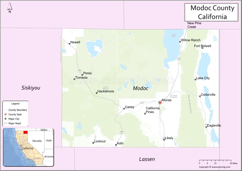
About Modoc County Map, California: The map showing the county boundary, county seat, major cities, highways, water bodies and neighbouring counties.
More California Links
About Modoc County, California
Modoc County is a county located in the northeastern corner of the state of California, in the United States. The county seat and only incorporated city is Alturas. As of the 2020 census, the population was 8,101. Modoc County was established on 1874.
Modoc County is bordered by Oregon to the north and Nevada to the east. It is the third-least populous county in California and one of the most rural counties in the state.
The economy of Modoc County is primarily based on agriculture, with cattle and hay being the most important products. Timber production and mining are also significant industries in the county. The Modoc National Forest, which covers over one million acres, is a major source of recreation and tourism for the area.
Modoc County is known for its stunning natural beauty and outdoor recreational opportunities, including hiking, fishing, hunting, and camping. The county is also home to several wildlife refuges and protected areas, such as the Modoc National Wildlife Refuge, which provides habitat for many migratory bird species.
Facts about Modoc County, California
| Country | United States |
| State | California |
| Region | Northeastern California (Great Basin) |
| County Seat | Alturas |
| Named After | Modoc Native American tribe |
| Established | 1874 |
| Organized | 1874 |
| Coordinates | 41.5926° N, 120.7243° W |
| Total Area | 4,203 sq mi |
| Land Area | 3,918 sq mi |
| Water Area | 285 sq mi |
| Population (2020) | 8,700 |
| Population Rank | One of the least populous counties in California |
| Major City | Alturas |
| Main Industries | Agriculture, Forestry, Government Services |
| Major Airport | Alturas Municipal Airport |
| Time Zone | Pacific Time (UTC−08:00) |
| Known For | High desert landscapes, Lava Beds National Monument (nearby), Wildlife refuges |
| Website | https://www.co.modoc.ca.us |
Ctities and Towns in Modoc County
| City Name | Type | Population (2020) | Pop. Density | Area | Incorporated |
|---|---|---|---|---|---|
| Alturas | City | 2,715 | 956.0/sq mi (369.1/km2) | 2.84 sq mi (7.4 km2) | September 16, 1901 |
Places to Visit in Modoc County
Top places to visit in Modoc includes Modoc National Forest, Modoc National Wildlife Refuge, Tule Lake Relocation, South Warner ,Surprise Valley Veterinary Center.
Highways in Modoc County
U.S. Route 395, State Route 139, State Route 299.
Nearest Airports
Nearest airport of Modoc is Tulelake Muni Airport-O81.
- Alameda County Map
- Alpine County Map
- Amador County Map
- Butte County Map
- Calaveras County Map
- Colusa County Map
- Contra Costa County Map
- Del Norte County Map
- El Dorado County Map
- Fresno County Map
- Glenn County Map
- Humboldt County Map
- Imperial County Map
- Inyo County Map
- Kern County Map
- Kings County Map
- Lake County Map
- Lassen County Map
- Los Angeles County Map
- Madera County Map
- Marin County Map
- Mariposa County Map
- Mendocino County Map
- Merced County Map
- Modoc County Map
- Mono County Map
- Monterey County Map
- Napa County Map
- Nevada County Map
- Orange County Map
- Placer County Map
- Plumas County Map
- Riverside County Map
- Sacramento County Map
- San Benito County Map
- San Bernardino County Map
- San Diego County Map
- San Francisco County Map
- San Joaquin County Map
- San Luis Obispo County Map
- San Mateo County Map
- Santa Barbara County Map
- Santa Clara County Map
- Santa Cruz County Map
- Shasta County Map
- Sierra County Map
- Siskiyou County Map
- Solano County Map
- Sonoma County Map
- Stanislaus County Map
- Sutter County Map
- Tehama County Map
- Trinity County Map
- Tulare County Map
- Tuolumne County Map
- Ventura County Map
- Yolo County Map
- Yuba County Map
- Alabama Counties
- Alaska boroughs
- Arizona Counties
- Arkansas Counties
- California County Map
- Colorado Counties
- Connecticut Counties
- Delaware Counties
- Florida County Map
- Georgia County Map
- Hawaii Counties
- Idaho Counties
- Illinois Counties
- Indiana Counties
- Iowa Counties
- Kansas Counties
- Kentucky Counties
- Louisiana Counties
- Maine Counties
- Maryland Counties
- Massachusetts Counties
- Michigan County Map
- Minnesota Counties
- Mississippi Counties
- Missouri Counties
- Montana Counties
- Nebraska Counties
- Nevada Counties
- New York Counties
- New Hampshire Counties
- New Jersey Counties
- New Mexico Counties
- North Carolina Counties
- North Dakota Counties
- Ohio County Map
- Oklahoma Counties
- Oregon Counties
- Pennsylvania Counties
- Rhode Island Counties
- South Carolina Counties
- South Dakota Counties
- Map of Tennessee
- Texas County Map
- Utah Counties
- Vermont Counties
- Virginia Counties
- Washington Counties
- West Virginia Counties
- Wisconsin Counties
- Wyoming Counties