
Where is Torrance Located? - Torrance is a city located in the Los Angeles County of California, United States. Torrance lies between 39.6172 Degrees North latitudes and 104.9508 Degrees West longitudes.
Location Map of Torrance, California
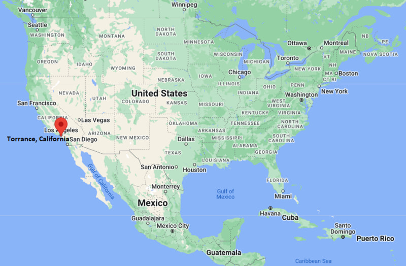
Torrance Map, California, USA
Where is Torrance?: The Google Map showing the location of Torrance in the U.S. state of California.
Where is Torrance Located?
Torrance is a city located in the Los Angeles County of California, United States. Torrance lies between 39.6172 Degrees North latitudes and 104.9508 Degrees West longitudes. According to 2020 U.S.census, the population of Torrance city is 147067 people and the city has a total area of 20.52 sq mi. The city has numerous parks and recreational facilities.
Most Viewed US Maps
| USA Sttae Map | USA Region Map | USA Road Map |
| USA County Map | Where is USA in World Map? | US ZIP Code Map |
| USA Time Zones Map | US State and Capitals Map | USA Physical Map |
Find 4,400+ U.S. Cities by State - Explore Their Locations and Get Detailed Information
Torrance, California Quick Facts
| Attribute | Details |
|---|---|
| City | Torrance |
| County | Los Angeles County |
| State | California |
| State Capital | Sacramento |
| US Region | Western United States |
| Latitude | 33.8358° N |
| Longitude | 118.3406° W |
| Elevation | Approximately 89 ft (27 m) |
| Land Area | 20.5 sq mi |
| Water Area | 0.0 sq mi |
| Total Area | 20.5 sq mi |
| Population (2020 Census) | 147,067 |
| Population Density | Approximately 7,170 per sq mi |
| ZIP Codes | 90501–90510 |
| Area Code | 310, 424 |
| Time Zone Standard | Pacific Standard Time (PST), UTC−8 |
| Time Zone Daylight | Pacific Daylight Time (PDT), UTC−7 |
| Currency | United States Dollar (USD) |
| FIPS Code | 06-80000 |
| Community Type | City |
Transportation and Connectivity in Torrance, California
| Transportation | Details |
|---|---|
| Airport Name | Los Angeles International Airport |
| IATA Code | LAX |
| Regional Airport | Torrance Municipal Airport (Zamperini Field) |
| Port | Port of Los Angeles and Port of Long Beach |
| Major Highways | Interstate 405, State Route 1, State Route 107 |
| Train/Amtrak Service | Nearby Metro C Line and Amtrak services in Los Angeles area |
| Local Transit Service | Torrance Transit and Los Angeles County Metro services |
- Interstate 405 (I-405) — Major north-south freeway connecting Torrance with Los Angeles, Orange County, and coastal communities.
- Pacific Coast Highway (State Route 1) — Scenic coastal route providing access along Southern California beaches.
- State Route 107 (Hawthorne Boulevard) — Important local route connecting Torrance with nearby South Bay communities.
Top Places to Visit in Torrance, California
| Landmark Name | Type |
|---|---|
| Del Amo Fashion Center | Shopping Center |
| Madrona Marsh Nature Center | Nature Preserve |
| Torrance Beach | Beach Destination |
| Wilson Park | Public Park |
| Chen Art Gallery | Art Museum |
| Western Museum of Flight | Aviation Museum |
| Torrance Historical Society and Museum | History Museum |
| Los Arboles Rocketship Park | Community Park |
| South Coast Botanic Garden | Botanical Garden |
| Redondo Beach Pier | Waterfront Attraction |
Driving Distances from Torrance, California to Nearby Cities
| City | State | Distance (mi) | Approx. Drive Time |
|---|---|---|---|
| Los Angeles | California | 20 mi | 35 minutes |
| Long Beach | California | 12 mi | 25 minutes |
| Santa Monica | California | 20 mi | 40 minutes |
| Anaheim | California | 35 mi | 45 minutes |
| Pasadena | California | 35 mi | 50 minutes |
| Riverside | California | 70 mi | 1 hour 20 minutes |
| San Diego | California | 120 mi | 2 hours |
| Santa Barbara | California | 105 mi | 2 hours |
| Palm Springs | California | 120 mi | 2 hours |
| Las Vegas | Nevada | 270 mi | 4 hours |
Colleges and Universities Near Torrance, California
| Institution Name | Type | Level | Notable For |
|---|---|---|---|
| El Camino College | Public | Community College | Transfer programs, technical education, and workforce training |
| Loyola Marymount University | Private | University | Business, film, engineering, and liberal arts programs |
| California State University, Dominguez Hills | Public | University | Business, education, health sciences, and public programs |
| University of Southern California | Private | University | Research, engineering, business, medicine, and arts programs |
| Torrance Unified School District | Public | K–12 District | Local public education |
Waterbodies Near Torrance, California
Pacific Ocean, Santa Monica Bay, Dominguez Channel, Machado Lake, Madrona Marsh wetlands
Golf Courses and Stadiums Near Torrance
Golf Courses: Torrance Municipal Golf Course, Palos Verdes Golf Club, Rolling Hills Country Club, Los Verdes Golf Course. Stadiums: Toyota Arena, Dignity Health Sports Park, SoFi Stadium, and local Torrance athletic facilities.
Key Landmarks and Places to Visit in Torrance, California
| Landmark Name | Type |
|---|---|
| Torrance Beach | Beach Recreation Area |
| Del Amo Fashion Center | Shopping Center |
| Madrona Marsh Nature Center | Nature Preserve |
| Western Museum of Flight | Aviation Museum |
| Torrance Historical Society and Museum | History Museum |
| South Coast Botanic Garden | Botanical Garden |
| Wilson Park | Public Park |
| Chen Art Gallery | Art Museum |
| Redondo Beach Pier | Waterfront Attraction |
| Palos Verdes Peninsula | Scenic Coastal Area |
Torrance, California — Key Historical Facts
- Torrance was founded in 1912 as a planned industrial community by real estate developer Jared Sidney Torrance.
- The city was designed as a model community combining residential neighborhoods, industry, and transportation access.
- The arrival of the Pacific Electric Railway helped connect Torrance with the greater Los Angeles region.
- Torrance became an important manufacturing center with industries including steel production, automotive manufacturing, and aerospace.
- The city experienced major growth after World War II as the South Bay region expanded.
- Today, Torrance is known for its beaches, Japanese cultural influences, business centers, parks, and high-quality residential neighborhoods.
References
- United States Census Bureau
- City of Torrance Official Website
- Los Angeles County Official Website
- State of California Official Website
- Los Angeles Tourism
California Related Links
- Where is Los Angeles
- Where is San Diego
- Where is San Francisco
- Where is Anaheim
- Where is Bakersfield
- Where is Chula Vista
- Where is Freemont
- Where is Fresno
- Where is Glendale
- Where is Irvine
- Where is Long Beach
- Where is Modesto
- Where is Oakland
- Where is Paradise
- Where is Riverside
- Where is Sacramento
- Where is San Bernardino
- Where is San Jose
- Where is Santa Ana
- Where is Stockton
- Where is Berkeley
- Where is Clovis
- Where is Corona
- Where is Elk Grove
- Where is Escondido
- Where is Fontana
- Where is Fremont
- Where is Fullerton
- Where is Garden Grove
- Where is Hayward
- Where is Huntington Beach
- Where is Lancaster
- Where is Moreno Valley
- Where is Oceanside
- Where is Ontario
- Where is Orange
- Where is Oxnard
- Where is Palmdale
- Where is Pasadena
- Where is Pomona
- Where is Rancho Cucamonga
- Where is Roseville
- Where is Salinas
- Where is Santa Clara
- Where is Santa Clarita
- Where is Santa Rosa
- Where is Sunnyvale
- Where is Thousand Oaks
- Where is Torrance
- Where is Vallejo
- Where is Victorville
- Where is Visalia