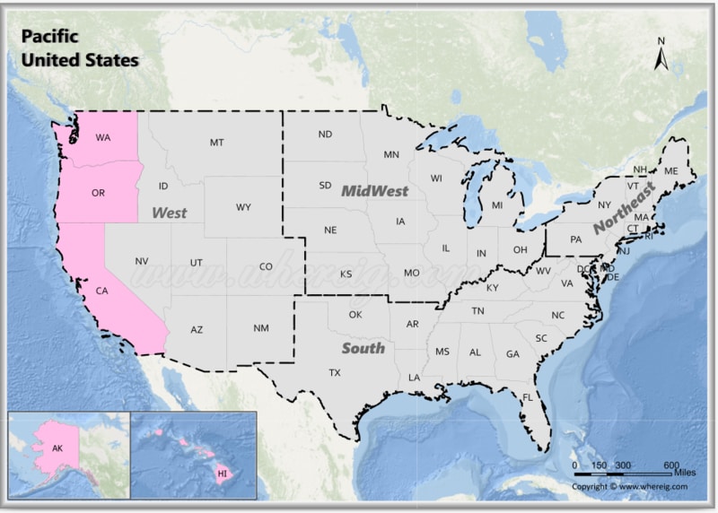
The Pacific States of the United States are located along the western coast, bordering the Pacific Ocean. The Pacific States include five states: Alaska, California, Hawaii, Oregon and Washington. This region features a variety of landscapes, including coastal areas, mountains, forests, and islands.
Map of Pacific States, USA
 About Map - Map showing Pacific United States.
Pacific States
The United States' West Coast is often referred to as the Western Seaboard, the Pacific Coast, and the Pacific States. The West Coast of the United States is the point where the Western United States joins the North Pacific Ocean. According to the United States Census Bureau of U.S geographic division, the West Coast of the United States consists of the following states: California, Oregon, Washington, Alaska and Hawaii.
There are various definitions of which states make up the West Coast of the United States, but California, Oregon, and Washington are universally considered to be a component of that definition. However, since all of them are in North America, the term typically refers to the three contiguous states as well as Alaska. Hawaii and the other four states are considered to be a part of the West Coast for census purposes. Alaska and British Columbia are included in the region of North America that is referred to as the Pacific Coast by Encyclopaedia Britannica. Hawaii is listed as being a part of the area in the encyclopedia, but the editors noted that it "had very little connection geologically with the mainland states."
The West Coast of the United States has a Mediterranean climate from Northern California to the U.S.-Mexico border, but it has an oceanic climate along its Northwestern, Northern, and Eastern edges toward the U.S.-Canada border. While the majority of coastal California has year-round dryness, the northern portion of the west coast, particularly coastal Washington and Oregon, experiences modest rainfall, especially during the winter months. The Democratic Party has dominated West Coast politics in recent history, with the exception of Alaska, and the states consistently support Democrats in elections at all levels. Since 1992, Democrats have won four of the five West Coast states' presidential votes, including three that have done so since 1988. The West Coast's culture is significantly younger than that of the East Coast because immigrants and their offspring arrived there more recently. Furthermore, its population makeup contributes to its cultural distinction from the rest of the United States.
Among the Pacific States of USA Region Alaska is the biggest country in terms of land area with 570,641 square miles. Hawaii is the smallest region among the Pacific States of the USA Region. California is one of the Pacific States of the USA Region with the highest number of population. The least populated state among the Pacific States of the USA Region is Hawaii.
The Pacific United States consists of five states: Alaska, California, Hawaii, Oregon, and Washington. Popular cities in the Pacific region are Los Angeles, Seattle, San Diego, San Jose, San Francisco, Fresno, Anchorage, Honolulu, and Portland.
List of Pacific United States with Capitals
| State | Capital | Major Cities | Populaion 2020 Census | Land Area (Sq mi) | Density (Sq mi) | Total County |
|---|---|---|---|---|---|---|
| Alaska | Juneau | Anchorage, Fairbanks, Juneau, Sitka and Ketchikan | 733,391 | 570,641 sq mi (1,477,953 km2) | 1.3 | 30 |
| California | Sacramento | Los Angeles, San Diego, San Jose, San Francisco, Fresno and Sacramento | 39,538,223 | 155,779 sq mi (403,466 s. km) | 249.1 | 58 |
| Hawaii | Honolulu | Honolulu, Hilo1, Kailua1, Kapolei1 and Kaneohe1 | 1,455,271 | 6,423 sq mi (16,635 km2) | 221 | 5 |
| Oregon | Salem | Portland, Eugene, Salem, Gresham and Hillsboro | 4,237,256 | 95,988 sq mi (248,608 km2) | 41.4 | 36 |
| Washington | Olympia | Seattle, Spokane, Tacoma, Vancouver, Bellevue and Olympia | 7,705,281 | 66,456 sq mi (172,119 km2) | 106.3 | 39 |
