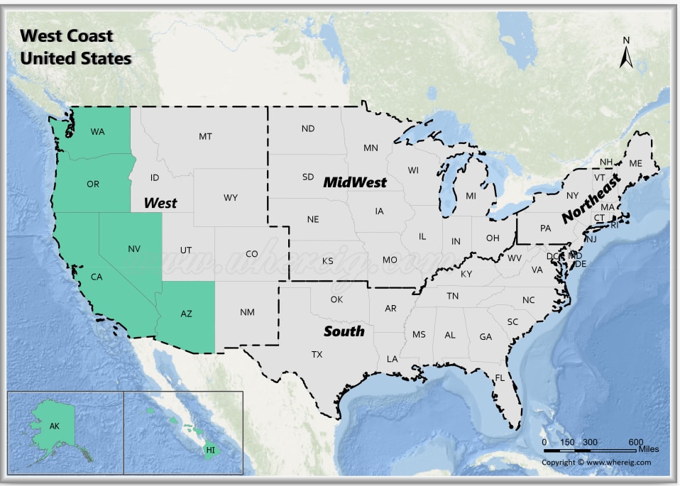
The West Coast of the United States, also known as the Pacific Coast, Pacific states. West Coast refers to the westernmost coastal states touching the Pacific Ocean. The West Coast is known for its beautiful beaches, world-famous zoo, beautiful cities, fantastic historical tour, and a young, diverse population.
Map of West Coast States, USA
 About Map - Map showing West Coast United States.
West Coast of the United States
The West Coast United States consists of fourteen states: Alaska, Arizona, California, Hawaii, Nevada, Oregon and Washington. Principal cities in the West Coast region are Los Angeles, San Diego, San Jose, San Francisco, Portland, Seattle, Anchorage and Honolulu.
The West Coast of the United States is the coastline along which the Western United States meets the North Pacific Ocean. The word ‘the West Coast of the United States’ usually refers to the three contiguous states of the United States—California, Oregon, and Washington—but it also occasionally refers to Alaska and Hawaii, particularly when used by the United States Census Bureau to describe a region of the country.
The oldest known inhabitants of the Americas, the Paleo-Indians, crossed the Bering Strait from Eurasia into North America through a land bridge called Beringia between 45,000 and 12,000 years ago, marking the beginning of the history of the West Coast of the United States. Small, isolated communities of hunter-gatherers moved into Alaska along with herds of huge mammals. Ice-free passageways formed along the Pacific coast and in the valleys of North America between 16,500 BCE and 13,500 BCE.
The West Coast of the United States has a Mediterranean climate from Northern California to the U.S.-Mexico border, but it has an oceanic climate along its Northwestern, Northern, and Eastern edges toward the U.S.-Canada border. A Mediterranean climate, also known as a dry summer temperate climate Cs, is a sub-type of temperate climate distinguished by dry summers and mild, wet winters. The humid temperate climate is known as an oceanic climate, also known as a marine climate. California has the biggest population on the West Coast of the United States.
Many spectacular and stunning stretches of beach can be found in California and the Pacific Northwest. Water temperatures on the West Coast of United States are significantly colder than those in Florida or Texas. Some of the famous beaches of West Coast of United States are Coronado Beach, Cannon Beach, Rialto Beach, Carmel Beach, Westport Beach, La Jolla Cove, Butterfly Beach, and Salmon Creek Beach.
List of US West Coast States with Capitals
| State | Capital | Major Cities | Populaion 2020 Census | Land Area (Sq mi) | Density (Sq mi) | Total County |
|---|---|---|---|---|---|---|
| Alaska | Juneau | Anchorage, Fairbanks, Juneau, Sitka and Ketchikan | 733,391 | 570,641 sq mi (1,477,953 km2) | 1.3 | 30 |
| Arizona | Phoenix | Phoenix, Tucson, Mesa, Chandler and Glendale | 7,151,502 | 113,594 sq mi (294,207 km2) | 59.3 | 15 |
| California | Sacramento | Los Angeles, San Diego, San Jose, San Francisco, Fresno and Sacramento | 39,538,223 | 155,779 sq mi (403,466 s. km) | 249.1 | 58 |
| Hawaii | Honolulu | Honolulu, Hilo1, Kailua1, Kapolei1 and Kaneohe1 | 1,455,271 | 6,423 sq mi (16,635 km2) | 221 | 5 |
| Nevada | Carson City | Las Vegas, Henderson, North Las Vegas, Reno, Sparks and Carson City | 3,104,614 | 109,781 sq mi (284,332 km2) | 25.9 | 17 |
| Oregon | Salem | Portland, Eugene, Salem, Gresham and Hillsboro | 4,237,256 | 95,988 sq mi (248,608 km2) | 41.4 | 36 |
| Washington | Olympia | Seattle, Spokane, Tacoma, Vancouver, Bellevue and Olympia | 7,705,281 | 66,456 sq mi (172,119 km2) | 106.3 | 39 |
West Coast USA Facts
| Region Name | West Coast of the United States |
| Country | United States of America |
| Geographic Definition | U.S. states bordering the Pacific Ocean |
| States Included | California, Oregon, Washington |
| Number of States | 3 |
| Total Population (2025 est.) | 55-57 million |
| Total Area | 403,000 sq mi (1.04 million km²) |
| Most Populous State | California |
| Largest City | Los Angeles, California |
| Major Cities | Los Angeles, San Diego, San Francisco, San Jose, Seattle, Portland |
| Capital Cities | Sacramento, Salem, Olympia |
| Climate | Mediterranean (California), oceanic (Pacific Northwest), coastal influence |
| Major Rivers | Columbia River, Sacramento River, San Joaquin River |
| Major Mountain Ranges | Sierra Nevada, Cascade Range, Coastal Ranges |
| Major Water Body | Pacific Ocean |
| Economic Profile | Technology, entertainment, agriculture, ports and trade, renewable energy |
| Cultural Significance | Innovation hubs, film and music industries, diverse cultures, coastal lifestyle |
| Major Tourist Attractions | Golden Gate Bridge, Yosemite National Park, Hollywood, Big Sur, Mount Rainier National Park, Olympic National Park |
| Time Zones | UTC -8 (Pacific Time) |
| Famous For | Pacific coastline, tech industry, national parks, beaches, film studios |
