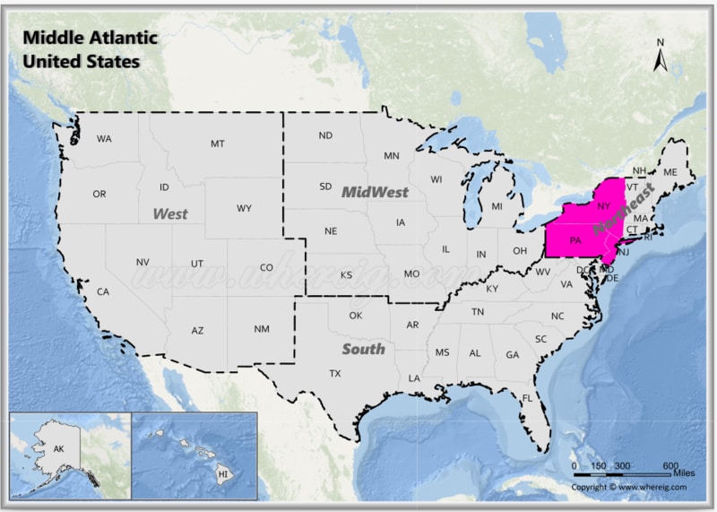
The Mid-Atlantic region, is one of the nine Census Bureau Divisions of the United States.
Map of Mid-Atlantic USA States
 About Map - Map showing Mid-Atlantic United States.
The Mid-Atlanticern United States consists of three states: New Jersey, New York, and Pennsylvania. Popular cities in the Mid-Atlantic States are New York City, Newark, Philadelphia, Pittsburgh, Buffalo and Jersey City.
Most Viewd Links
List of Mid-Atlanticern United States
| State | Capital | Major Cities | Populaion 2020 Census | Land Area (Sq mi) | Density (Sq mi) | Total County |
|---|---|---|---|---|---|---|
| New Jersey | Trenton | Newark, Jersey City, Paterson, Elizabeth, Edison and Trenton | 9,288,994 | 7,354 sq mi (19,047 km2) | 1,215.40 | 21 |
| New York | Albany | New York, Buffalo, Rochester, Yonkers, Syracuse and Albany | 20,201,249 | 47,126 sq mi (122,057 km2) | 419 | 62 |
| Pennsylvania | Harrisburg | Philadelphia, Pittsburgh, Allentown, Erie, Reading and Harrisburg | 13,002,700 | 44,743 sq mi (115,883 km2) | 285.8 | 67 |
U.S. Mid-Atlantic States Facts
| Region Name | Mid-Atlantic States |
| Country | United States of America |
| U.S. Census Classification | Northeast (Middle Atlantic Division) |
| States & Territory Included | New York, New Jersey, Pennsylvania, Delaware, Maryland, Washington, D.C. |
| Number of States/Territories | 6 |
| Total Population (2025 est.) | 65-68 million |
| Total Area | 200,000 sq mi (518,000 km²) |
| Most Populous State | New York |
| Largest City | New York City |
| Major Cities | New York City, Philadelphia, Baltimore, Newark, Jersey City, Wilmington, Washington, D.C. |
| Capital Cities | Albany, Trenton, Harrisburg, Dover, Annapolis, Washington, D.C. |
| Climate | Humid continental in the north, humid subtropical in the south, coastal influences |
| Major Rivers | Hudson River, Delaware River, Susquehanna River, Potomac River |
| Major Water Bodies | Atlantic Ocean, Chesapeake Bay, Delaware Bay |
| Economic Profile | Finance, government, healthcare, education, manufacturing, ports and logistics |
| Cultural Significance | Early U.S. history, immigration hubs, political centers, arts and media |
| Time Zone | UTC -5 (Eastern Time) |
| Famous For | Wall Street, U.S. Capitol, major ports, historic cities, cultural diversity |
