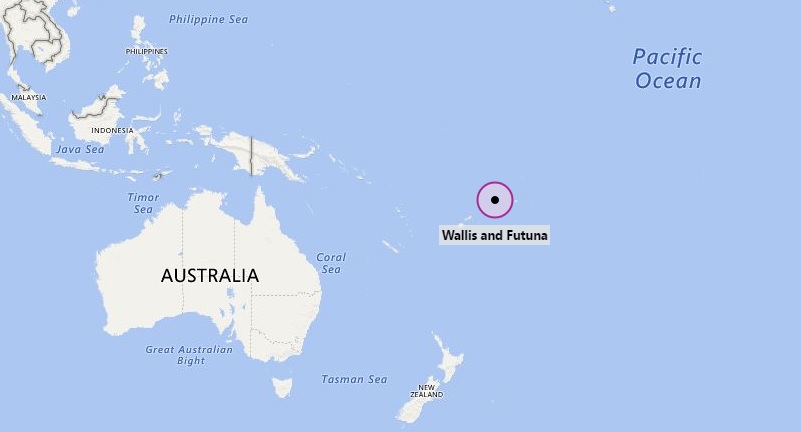
Where is Wallis and Futuna Islands located on the world map? The given Wallis and Futuna Islands location map shows that Wallis and Futuna Islands is located in the South Pacific Ocean.
The Wallis and Futuna Islands map also depicts that it is geographically situated between Tuvalu in the north-west, Rotuma of Fiji in the west, the main part of Fiji in the south-west, Tonga in the south-east, Samoa in the east, and the Tokelau in the north-east. Furthermore, it is located at the opposite western end of Polynesia.
Mata-Utu is the largest and capital city of Wallis and Futuna Islands. However, the territory is constituted of three main volcanic tropical islands along with a number of tiny islets. This group of islands is further divided into two island groups i.e. Wallis Islands (Uvea) in the northeast, and Futuna Islands (Hoorn Islands).
The sovereignty of the territory belongs to France. Since the year 2003, Wallis and Futuna has been a French overseas collectivity. Before that it had the status of a French overseas territory.
The economy of the territory largely depends upon agriculture and the important produces are breadfruit, yams, taro, bananas, pigs, and goats. However, it has also some manufacturing industries such as copra, handicrafts, fishing, and lumber.
Official Name- Territory of the Wallis and Futuna Islands
Capital City- Mata-Utu
Official Language- French
Government- Overseas collectivity of France
Area- 264 km2
Population- 15289
Ethnic Groups- Polynesian
Currency- Cfp Franc (Xpf)
Time Zone- UTC+12
ISO Code- WF
Calling Code- 681
Mata-Utu is the largest and capital city of Wallis and Futuna Islands. However, the territory is constituted of three main volcanic tropical islands along with a number of tiny islets. This group of islands is further divided into two island groups i.e. Wallis Islands (Uvea) in the northeast, and Futuna Islands (Hoorn Islands).
The sovereignty of the territory belongs to France. Since the year 2003, Wallis and Futuna has been a French overseas collectivity. Before that it had the status of a French overseas territory.
The economy of the territory largely depends upon agriculture and the important produces are breadfruit, yams, taro, bananas, pigs, and goats. However, it has also some manufacturing industries such as copra, handicrafts, fishing, and lumber.
Wallis and Futuna Facts
:-Official Name- Territory of the Wallis and Futuna Islands
Capital City- Mata-Utu
Official Language- French
Government- Overseas collectivity of France
Area- 264 km2
Population- 15289
Ethnic Groups- Polynesian
Currency- Cfp Franc (Xpf)
Time Zone- UTC+12
ISO Code- WF
Calling Code- 681
- Where is American Samoa
- Where is Ashmore and Cartier Islands
- Where is Australia
- Where is Cook Islands
- Where is Coral Sea Islands
- Where is Federated States of Micronesia
- Where is Fiji
- Where is French Polynesia
- Where is Guam
- Where is Kiribati
- Where is Marshall Islands
- Where is Nauru
- Where is New Caledonia
- Where is New Zealand
- Where is Niue
- Where is Norfolk Island
- Where is Northern Mariana Islands
- Where is Palau
- Palmyra Atoll
- Papua New Guinea
- Where is Paracel Islands
- Where is Pitcairn Islands
- Where is Samoa
- Where is Solomon Islands
- Where is Tokelau
- Where is Tonga
- Where is Tuvalu
- Where is Vanuatu
- Where is Wake Island
- Where is Wallis and Futuna


