Map of Hartford County - Hartford County is a county located in the U.S. state of Connecticut. Hartford County Map showing cities, highways, important places and water bodies. Get Where is Hartford County located in the map, major cities in Hartford county, population, areas, and places of interest.
Hartford County Map, Connecticut
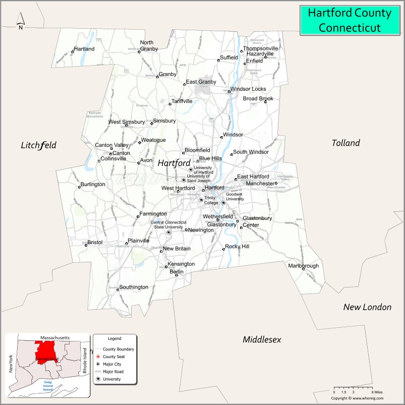
About Hartford County Map, Connecticut: The map showing the county boundary, county seat, major cities, highways, water bodies and neighbouring counties.
Most Viewed Links
Map of Hartford County, Connecticut
Hartford County is a county located in the U.S. state of Connecticut. It's county seat is Hartford. As per 2020 census, the population of Hartford County is 896854 people and population density is square miles. According to the United States Census Bureau, the county has a total area of 736 sq mi (1,906 km2). Hartford County was established on 1666.
Hartford County Facts
| Continent | North America |
| Country | United States |
| State | Connecticut |
| County Seat | None (Connecticut counties have no county government) |
| Largest City/Town | Hartford |
| Established | 1666 |
| Total Area | 751 sq mi (1,945 sq km) |
| Land Area | 735 sq mi (1,904 sq km) |
| Water Area | 16 sq mi (41 sq km) |
| Population | 899,498 (Census 2020) |
| Population Density | 1,224 people per sq mi |
| Time Zone | Eastern Time Zone (ET) |
| Major Highways | Interstate 84, Interstate 91, Interstate 291, Connecticut Route 9 |
| Major Rivers | Connecticut River, Farmington River, Park River |
| Neighboring Counties | Litchfield County, Tolland County, Middlesex County, New Haven County, Hampden County (Massachusetts) |
| Famous For | Insurance industry, state capital, historic architecture, education, New England culture |
| Top Attractions | Mark Twain House, Wadsworth Atheneum Museum of Art, Connecticut Science Center, Bushnell Park, Elizabeth Park |
| Official Website | Official Connecticut Website |
About Hartford County, Connecticut
Hartford County is located in north-central Connecticut in the United States along the Connecticut River and was established in 1666. Hartford is the capital city of Connecticut and the county’s largest city. The county is known for its insurance industry, historic New England communities, museums, educational institutions, and central role in Connecticut’s economy and government.
Cities and Towns in Hartford County, Connecticut
| City/Town | Population (Census 2020) | Latitude & Longitude |
|---|---|---|
| Hartford | 121,054 | 41.7658°N, 72.6734°W |
| New Britain | 74,135 | 41.6612°N, 72.7795°W |
| Bristol | 60,833 | 41.6718°N, 72.9493°W |
| West Hartford | 64,083 | 41.7620°N, 72.7420°W |
| Manchester | 59,713 | 41.7759°N, 72.5215°W |
| East Hartford | 50,731 | 41.7637°N, 72.6120°W |
| Enfield | 42,141 | 41.9762°N, 72.5918°W |
| Windsor | 29,492 | 41.8526°N, 72.6437°W |
| Southington | 43,501 | 41.5965°N, 72.8776°W |
| Farmington | 26,712 | 41.7198°N, 72.8320°W |
Golf Courses in Hartford County, Connecticut
| Golf Course | Location | Latitude & Longitude |
|---|---|---|
| Wintonbury Hills Golf Course | Bloomfield | 41.8535°N, 72.7292°W |
| Goodwin Park Golf Course | Hartford | 41.7186°N, 72.6990°W |
| Stanley Golf Course | New Britain | 41.6838°N, 72.8101°W |
Roads and Highways in Hartford County
Major highways connect the county with Boston, New York City, Springfield, and other Connecticut regions.
- Interstate 84 - major east-west interstate through Hartford and central Connecticut
- Interstate 91 - north-south interstate connecting Hartford with New Haven and Massachusetts
- Interstate 291 - beltway route around Hartford metropolitan areas
- Connecticut Route 9 - highway linking central Connecticut with shoreline regions
- U.S. Route 5 - historic regional roadway along the Connecticut River corridor
Neighboring Counties of Hartford County
- Litchfield County (west)
- Tolland County (east)
- Middlesex County (south)
- New Haven County (southwest)
- Hampden County, Massachusetts (north)
Top Attractions in Hartford County, Connecticut
The county offers museums, parks, historic landmarks, and cultural attractions in central Connecticut.
- Mark Twain House - historic home of author Mark Twain in Hartford
- Wadsworth Atheneum Museum of Art - oldest public art museum in the United States
- Connecticut Science Center - interactive science exhibits and educational attractions
- Bushnell Park - historic downtown park with carousel and monuments
- Elizabeth Park - famous rose gardens and walking trails in West Hartford
- XL Center - sports arena and entertainment venue in downtown Hartford
- New Britain Museum of American Art - major collection of American artworks
- Lake Compounce nearby - historic amusement park and water park
- Farmington Historic District - colonial architecture and scenic New England character
- Connecticut River Recreation - boating, parks, and riverside trails
Distance from Hartford County to Nearby Cities
The following distances are measured by road (driving).
- Hartford to Springfield (Hampden County), Massachusetts - 27 mi (43 km)
- Hartford to New Haven (New Haven County), Connecticut - 39 mi (63 km)
- Hartford to Providence (Providence County), Rhode Island - 66 mi (106 km)
- Hartford to Boston (Suffolk County), Massachusetts - 101 mi (163 km)
- Hartford to Bridgeport (Fairfield County), Connecticut - 58 mi (93 km)
- Hartford to Albany (Albany County), New York - 100 mi (161 km)
- Hartford to New York City (New York County), New York - 117 mi (188 km)
- Hartford to Philadelphia (Philadelphia County), Pennsylvania - 219 mi (352 km)
- Hartford to Portland (Cumberland County), Maine - 192 mi (309 km)
- Hartford to Baltimore (Baltimore City), Maryland - 321 mi (517 km)
- Hartford to Washington, D.C. - 363 mi (584 km)
- Hartford to Buffalo (Erie County), New York - 391 mi (629 km)
FAQs about Hartford County
Hartford County is located in north-central Connecticut along the Connecticut River.
Hartford County has a population of 899,498 according to the Census 2020.
The county is known for the insurance industry, Hartford as the state capital, museums, and historic New England communities.
Major highways include Interstate 84, Interstate 91, Interstate 291, and Connecticut Route 9.
Yes, Hartford County has golf facilities including Wintonbury Hills Golf Course and Goodwin Park Golf Course.
References
- QuickFacts - U.S. Census Bureau
- United States Census Bureau
- United States Geological Survey (USGS)
- Connecticut State Government
- National Geodetic Survey
- Alabama Counties
- Alaska boroughs
- Arizona Counties
- Arkansas Counties
- California County Map
- Colorado Counties
- Connecticut Counties
- Delaware Counties
- Florida County Map
- Georgia County Map
- Hawaii Counties
- Idaho Counties
- Illinois Counties
- Indiana Counties
- Iowa Counties
- Kansas Counties
- Kentucky Counties
- Louisiana Counties
- Maine Counties
- Maryland Counties
- Massachusetts Counties
- Michigan County Map
- Minnesota Counties
- Mississippi Counties
- Missouri Counties
- Montana Counties
- Nebraska Counties
- Nevada Counties
- New York Counties
- New Hampshire Counties
- New Jersey Counties
- New Mexico Counties
- North Carolina Counties
- North Dakota Counties
- Ohio County Map
- Oklahoma Counties
- Oregon Counties
- Pennsylvania Counties
- Rhode Island Counties
- South Carolina Counties
- South Dakota Counties
- Map of Tennessee
- Texas County Map
- Utah Counties
- Vermont Counties
- Virginia Counties
- Washington Counties
- West Virginia Counties
- Wisconsin Counties
- Wyoming Counties