Map of Litchfield County - Litchfield County is a county located in the U.S. state of Connecticut. Litchfield County Map showing cities, highways, important places and water bodies. Get Where is Litchfield County located in the map, major cities in Litchfield county, population, areas, and places of interest.
Litchfield County Map, Connecticut
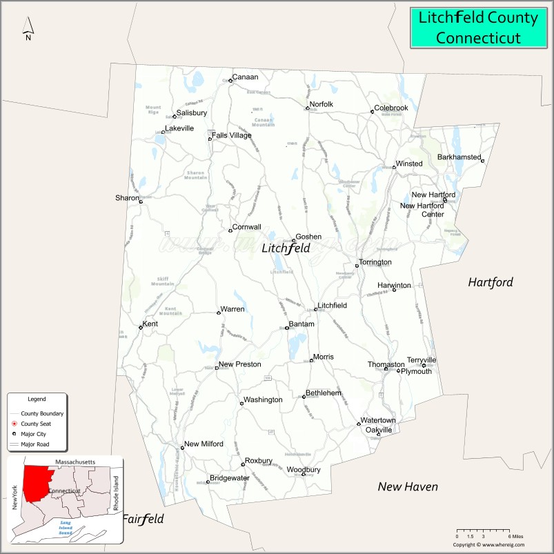
About Litchfield County Map, Connecticut: The map showing the county boundary, county seat, major cities, highways, water bodies and neighbouring counties.
Most Viewed Links
Map of Litchfield County, Connecticut
Litchfield County is a county located in the U.S. state of Connecticut. It's county seat is N/A. As per 2020 census, the population of Litchfield County is 185000 people and population density is square miles. According to the United States Census Bureau, the county has a total area of 920 sq mi (2,383 km2). Litchfield County was established on 1751.
Litchfield County Facts
| Continent | North America |
| Country | United States |
| State | Connecticut |
| County Seat | None (Connecticut counties have no county government) |
| Largest City/Town | Torrington |
| Established | 1751 |
| Total Area | 945 sq mi (2,448 sq km) |
| Land Area | 921 sq mi (2,385 sq km) |
| Water Area | 24 sq mi (62 sq km) |
| Population | 185,186 (Census 2020) |
| Population Density | 201 people per sq mi |
| Time Zone | Eastern Time Zone (ET) |
| Major Highways | Interstate 84, U.S. Route 7, U.S. Route 202, Connecticut Route 8 |
| Major Rivers | Housatonic River, Farmington River, Naugatuck River |
| Neighboring Counties | Fairfield County, Hartford County, New Haven County, Berkshire County (Massachusetts), Dutchess County (New York) |
| Famous For | Rural New England scenery, covered bridges, lakes, hiking, historic towns, fall foliage |
| Top Attractions | Lake Waramaug, Kent Falls State Park, Appalachian Trail, White Memorial Conservation Center, Mohawk Mountain |
| Official Website | Official Connecticut Website |
About Litchfield County, Connecticut
Litchfield County is located in northwestern Connecticut in the United States and was established in 1751. Torrington is the county’s largest city and serves as a regional commercial center. The county is known for scenic New England villages, forests, lakes, covered bridges, hiking trails, skiing, and colorful autumn landscapes.
Cities and Towns in Litchfield County, Connecticut
| City/Town | Population (Census 2020) | Latitude & Longitude |
|---|---|---|
| Torrington | 36,301 | 41.8007°N, 73.1212°W |
| New Milford | 28,115 | 41.5770°N, 73.4085°W |
| Watertown | 22,022 | 41.6062°N, 73.1182°W |
| Litchfield | 8,192 | 41.7473°N, 73.1887°W |
| Kent | 2,858 | 41.7248°N, 73.4779°W |
| Washington | 3,646 | 41.6304°N, 73.3107°W |
| Woodbury | 9,975 | 41.5443°N, 73.2090°W |
| Goshen | 2,976 | 41.8390°N, 73.2187°W |
| Sharon | 2,800 | 41.8784°N, 73.4768°W |
| Winchester | 10,630 | 41.9215°N, 73.0651°W |
Golf Courses in Litchfield County, Connecticut
| Golf Course | Location | Latitude & Longitude |
|---|---|---|
| Eastwood Country Club | Torrington | 41.7868°N, 73.1504°W |
| Green Woods Country Club | Winsted | 41.9348°N, 73.0934°W |
| Washington Club Golf Course | Washington | 41.6270°N, 73.3198°W |
Roads and Highways in Litchfield County
Major highways connect the county with New York, Hartford, and western New England communities.
- Interstate 84 - major east-west interstate crossing southern Litchfield County
- U.S. Route 7 - scenic north-south route through western Connecticut
- U.S. Route 202 - regional route connecting rural communities and historic towns
- Connecticut Route 8 - highway linking Torrington with Waterbury and southern Connecticut
- Connecticut Route 4 - scenic roadway through northwestern Connecticut villages
Neighboring Counties of Litchfield County
- Fairfield County (south)
- Hartford County (east)
- New Haven County (southeast)
- Berkshire County, Massachusetts (north)
- Dutchess County, New York (west)
Top Attractions in Litchfield County, Connecticut
The county offers mountain scenery, hiking trails, lakes, and historic New England attractions.
- Lake Waramaug - scenic lake known for boating, swimming, and fall foliage views
- Kent Falls State Park - waterfalls, hiking trails, and picnic areas
- Appalachian Trail - hiking route through scenic mountain landscapes
- White Memorial Conservation Center - nature museum, forests, and walking trails
- Mohawk Mountain - skiing and winter recreation destination
- Litchfield Historic District - colonial architecture, inns, and village charm
- Covered Bridges and Scenic Drives - classic New England countryside attractions
- Housatonic River Recreation - fishing, kayaking, and nature viewing
- Hopkins Vineyard - winery and vineyard overlooking Lake Waramaug
- Woodbury Antique Shops - shopping destination with historic New England character
Distance from Litchfield County to Nearby Cities
The following distances are measured by road (driving).
- Torrington to Hartford (Hartford County), Connecticut - 29 mi (47 km)
- Torrington to New Haven (New Haven County), Connecticut - 39 mi (63 km)
- Torrington to Bridgeport (Fairfield County), Connecticut - 51 mi (82 km)
- Torrington to Springfield (Hampden County), Massachusetts - 45 mi (72 km)
- Torrington to Albany (Albany County), New York - 74 mi (119 km)
- Torrington to New York City (New York County), New York - 117 mi (188 km)
- Torrington to Boston (Suffolk County), Massachusetts - 123 mi (198 km)
- Torrington to Providence (Providence County), Rhode Island - 98 mi (158 km)
- Torrington to Philadelphia (Philadelphia County), Pennsylvania - 219 mi (352 km)
- Torrington to Portland (Cumberland County), Maine - 214 mi (344 km)
- Torrington to Baltimore (Baltimore City), Maryland - 322 mi (518 km)
- Torrington to Washington, D.C. - 364 mi (586 km)
FAQs about Litchfield County
Litchfield County is located in northwestern Connecticut.
Litchfield County has a population of 185,186 according to the Census 2020.
The county is known for rural New England scenery, lakes, hiking trails, historic villages, and fall foliage.
Major highways include Interstate 84, U.S. Route 7, U.S. Route 202, and Connecticut Route 8.
Yes, Litchfield County has golf facilities including Eastwood Country Club and Green Woods Country Club.
References
- QuickFacts - U.S. Census Bureau
- United States Census Bureau
- United States Geological Survey (USGS)
- Connecticut State Government
- National Geodetic Survey
- Alabama Counties
- Alaska boroughs
- Arizona Counties
- Arkansas Counties
- California County Map
- Colorado Counties
- Connecticut Counties
- Delaware Counties
- Florida County Map
- Georgia County Map
- Hawaii Counties
- Idaho Counties
- Illinois Counties
- Indiana Counties
- Iowa Counties
- Kansas Counties
- Kentucky Counties
- Louisiana Counties
- Maine Counties
- Maryland Counties
- Massachusetts Counties
- Michigan County Map
- Minnesota Counties
- Mississippi Counties
- Missouri Counties
- Montana Counties
- Nebraska Counties
- Nevada Counties
- New York Counties
- New Hampshire Counties
- New Jersey Counties
- New Mexico Counties
- North Carolina Counties
- North Dakota Counties
- Ohio County Map
- Oklahoma Counties
- Oregon Counties
- Pennsylvania Counties
- Rhode Island Counties
- South Carolina Counties
- South Dakota Counties
- Map of Tennessee
- Texas County Map
- Utah Counties
- Vermont Counties
- Virginia Counties
- Washington Counties
- West Virginia Counties
- Wisconsin Counties
- Wyoming Counties