Map of Middlesex County - Middlesex County is a county located in the U.S. state of Connecticut. Middlesex County Map showing cities, highways, important places and water bodies. Get Where is Middlesex County located in the map, major cities in Middlesex county, population, areas, and places of interest.
Middlesex County Map, Connecticut
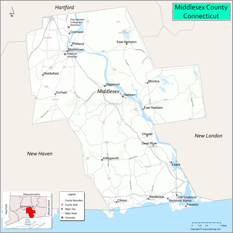
About Middlesex County Map, Connecticut: The map showing the county boundary, county seat, major cities, highways, water bodies and neighbouring counties.
Most Viewed Links
Map of Middlesex County, Connecticut
Middlesex County is a county located in the U.S. state of Connecticut. It's county seat is Middletown. As per 2020 census, the population of Middlesex County is 164759 people and population density is square miles. According to the United States Census Bureau, the county has a total area of 369 sq mi (956 km2). Middlesex County was established on 1785.
Middlesex County Facts
| Continent | North America |
| Country | United States |
| State | Connecticut |
| County Seat | None (Connecticut counties have no county government) |
| Largest City/Town | Middletown |
| Established | 1785 |
| Total Area | 439 sq mi (1,137 sq km) |
| Land Area | 369 sq mi (956 sq km) |
| Water Area | 70 sq mi (181 sq km) |
| Population | 164,245 (Census 2020) |
| Population Density | 445 people per sq mi |
| Time Zone | Eastern Time Zone (ET) |
| Major Highways | Interstate 91 nearby, Connecticut Route 9, U.S. Route 1, Interstate 95 nearby |
| Major Rivers | Connecticut River, Salmon River, Hammonasset River |
| Neighboring Counties | Hartford County, New Haven County, New London County, Tolland County |
| Famous For | Connecticut River towns, maritime heritage, Wesleyan University, coastal recreation, historic villages |
| Top Attractions | Gillette Castle State Park, Essex Steam Train, Hammonasset Beach nearby, Wesleyan University, Connecticut River Museum |
| Official Website | Official Connecticut Website |
About Middlesex County, Connecticut
Middlesex County is located in south-central Connecticut in the United States along the Connecticut River and Long Island Sound and was established in 1785. Middletown is the county’s largest city and a regional educational and cultural center. The county is known for riverfront towns, maritime history, scenic coastal villages, higher education, and outdoor recreation.
Cities and Towns in Middlesex County, Connecticut
| City/Town | Population (Census 2020) | Latitude & Longitude |
|---|---|---|
| Middletown | 47,717 | 41.5623°N, 72.6506°W |
| Old Saybrook | 10,808 | 41.2962°N, 72.3762°W |
| Essex | 6,733 | 41.3515°N, 72.3845°W |
| Clinton | 13,185 | 41.2787°N, 72.5276°W |
| Westbrook | 6,975 | 41.2959°N, 72.4643°W |
| Cromwell | 14,225 | 41.5959°N, 72.6454°W |
| East Haddam | 8,962 | 41.4537°N, 72.4618°W |
| Portland | 9,384 | 41.5720°N, 72.6406°W |
| Deep River | 4,462 | 41.3862°N, 72.4356°W |
| Chester | 3,749 | 41.4020°N, 72.4515°W |
Golf Courses in Middlesex County, Connecticut
| Golf Course | Location | Latitude & Longitude |
|---|---|---|
| Lyman Orchards Golf Club | Middlefield | 41.5237°N, 72.7148°W |
| Portland Golf Course | Portland | 41.5794°N, 72.6217°W |
| Fenwick Golf Course | Old Saybrook | 41.2701°N, 72.3484°W |
Roads and Highways in Middlesex County
Major highways connect the county with Hartford, New Haven, shoreline communities, and eastern Connecticut.
- Connecticut Route 9 - primary north-south highway through Middlesex County
- Interstate 91 nearby - major interstate connecting Hartford and New Haven regions
- U.S. Route 1 - coastal roadway serving shoreline communities
- Interstate 95 nearby - major coastal interstate along Long Island Sound
- Connecticut Route 154 - scenic route along the Connecticut River
Neighboring Counties of Middlesex County
- Hartford County (north)
- New Haven County (west)
- New London County (east)
- Tolland County (north)
Top Attractions in Middlesex County, Connecticut
The county offers riverfront attractions, coastal recreation, museums, and historic New England villages.
- Gillette Castle State Park - unique stone castle overlooking the Connecticut River
- Essex Steam Train and Riverboat - scenic railroad and river excursions
- Hammonasset Beach State Park nearby - beaches, camping, and shoreline recreation
- Wesleyan University - historic university campus with arts and cultural programs
- Connecticut River Museum - maritime history exhibits and riverfront activities
- Historic Essex Village - boutiques, restaurants, marinas, and colonial architecture
- Goodspeed Opera House - renowned musical theater venue in East Haddam
- Old Saybrook Waterfront - beaches, marinas, and Long Island Sound scenery
- Cockaponset State Forest nearby - hiking, camping, and outdoor recreation
- Connecticut River Boating Areas - kayaking, fishing, and sightseeing opportunities
Distance from Middlesex County to Nearby Cities
The following distances are measured by road (driving).
- Middletown to Hartford (Hartford County), Connecticut - 17 mi (27 km)
- Middletown to New Haven (New Haven County), Connecticut - 22 mi (35 km)
- Middletown to New London (New London County), Connecticut - 39 mi (63 km)
- Middletown to Bridgeport (Fairfield County), Connecticut - 47 mi (76 km)
- Middletown to Providence (Providence County), Rhode Island - 67 mi (108 km)
- Middletown to Boston (Suffolk County), Massachusetts - 107 mi (172 km)
- Middletown to New York City (New York County), New York - 114 mi (183 km)
- Middletown to Albany (Albany County), New York - 112 mi (180 km)
- Middletown to Philadelphia (Philadelphia County), Pennsylvania - 216 mi (348 km)
- Middletown to Portland (Cumberland County), Maine - 198 mi (319 km)
- Middletown to Baltimore (Baltimore City), Maryland - 318 mi (512 km)
- Middletown to Washington, D.C. - 360 mi (579 km)
FAQs about Middlesex County
Middlesex County is located in south-central Connecticut along the Connecticut River and Long Island Sound.
Middlesex County has a population of 164,245 according to the Census 2020.
The county is known for riverfront towns, maritime heritage, Wesleyan University, and coastal recreation.
Major highways include Connecticut Route 9, U.S. Route 1, and nearby Interstate 91 and Interstate 95.
Yes, Middlesex County has golf facilities including Lyman Orchards Golf Club and Fenwick Golf Course.
References
- QuickFacts - U.S. Census Bureau
- United States Census Bureau
- United States Geological Survey (USGS)
- Connecticut State Government
- National Geodetic Survey
- Alabama Counties
- Alaska boroughs
- Arizona Counties
- Arkansas Counties
- California County Map
- Colorado Counties
- Connecticut Counties
- Delaware Counties
- Florida County Map
- Georgia County Map
- Hawaii Counties
- Idaho Counties
- Illinois Counties
- Indiana Counties
- Iowa Counties
- Kansas Counties
- Kentucky Counties
- Louisiana Counties
- Maine Counties
- Maryland Counties
- Massachusetts Counties
- Michigan County Map
- Minnesota Counties
- Mississippi Counties
- Missouri Counties
- Montana Counties
- Nebraska Counties
- Nevada Counties
- New York Counties
- New Hampshire Counties
- New Jersey Counties
- New Mexico Counties
- North Carolina Counties
- North Dakota Counties
- Ohio County Map
- Oklahoma Counties
- Oregon Counties
- Pennsylvania Counties
- Rhode Island Counties
- South Carolina Counties
- South Dakota Counties
- Map of Tennessee
- Texas County Map
- Utah Counties
- Vermont Counties
- Virginia Counties
- Washington Counties
- West Virginia Counties
- Wisconsin Counties
- Wyoming Counties