Map of Windham County - Windham County is a county located in the U.S. state of Connecticut. Windham County Map showing cities, highways, important places and water bodies. Get Where is Windham County located in the map, major cities in Windham county, population, areas, and places of interest.
Windham County Map, Connecticut
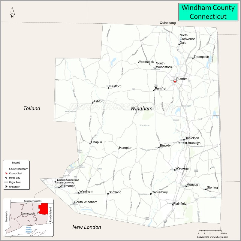
About Windham County Map, Connecticut: The map showing the county boundary, county seat, major cities, highways, water bodies and neighbouring counties.
Most Viewed Links
Map of Windham County, Connecticut
Windham County is a county located in the U.S. state of Connecticut. It's county seat is Willimantic. As per 2020 census, the population of Windham County is 116418 people and population density is square miles. According to the United States Census Bureau, the county has a total area of 513 sq mi (1,329 km2). Windham County was established on 1726.
Windham County Facts
| Continent | North America |
| Country | United States |
| State | Connecticut |
| County Seat | None (Connecticut counties have no county government) |
| Largest City/Town | Windham |
| Established | 1726 |
| Total Area | 521 sq mi (1,349 sq km) |
| Land Area | 513 sq mi (1,329 sq km) |
| Water Area | 8 sq mi (20 sq km) |
| Population | 116,418 (Census 2020) |
| Population Density | 227 people per sq mi |
| Time Zone | Eastern Time Zone (ET) |
| Major Highways | Interstate 395, U.S. Route 6, U.S. Route 44, Connecticut Route 32 |
| Major Rivers | Quinebaug River, Willimantic River, Shetucket River |
| Neighboring Counties | Tolland County, New London County, Worcester County (Massachusetts), Providence County (Rhode Island) |
| Famous For | Quiet Corner region, rural New England scenery, historic mills, forests, agriculture, outdoor recreation |
| Top Attractions | Roseland Cottage, Mashamoquet Brook State Park, Old Sturbridge Village nearby, Air Line State Park Trail, Quinebaug Valley |
| Official Website | Official Connecticut Website |
About Windham County, Connecticut
Windham County is located in northeastern Connecticut in the United States and was established in 1726. Windham is the county’s largest municipality and includes the village of Willimantic. The county is known for its Quiet Corner rural landscapes, forests, historic mill towns, agriculture, scenic drives, and outdoor recreation opportunities.
Cities and Towns in Windham County, Connecticut
| City/Town | Population (Census 2020) | Latitude & Longitude |
|---|---|---|
| Windham | 24,428 | 41.6995°N, 72.1570°W |
| Putnam | 9,214 | 41.9168°N, 71.9073°W |
| Killingly | 17,752 | 41.8412°N, 71.8778°W |
| Plainfield | 15,696 | 41.6762°N, 71.9159°W |
| Brooklyn | 8,450 | 41.7887°N, 71.9498°W |
| Canterbury | 5,045 | 41.6984°N, 72.0240°W |
| Pomfret | 4,266 | 41.8973°N, 71.9634°W |
| Thompson | 9,189 | 41.9812°N, 71.8790°W |
| Ashford | 4,191 | 41.8734°N, 72.1215°W |
| Chaplin | 2,151 | 41.7973°N, 72.1256°W |
Golf Courses in Windham County, Connecticut
| Golf Course | Location | Latitude & Longitude |
|---|---|---|
| Quinebaug Valley Country Club | Putnam | 41.9246°N, 71.9087°W |
| Connecticut National Golf Club | Putnam | 41.9390°N, 71.9508°W |
| Moosup Valley Country Club | Foster nearby | 41.7770°N, 71.7484°W |
Roads and Highways in Windham County
Major highways connect the county with Rhode Island, Massachusetts, and central Connecticut.
- Interstate 395 - major north-south interstate through eastern Connecticut
- U.S. Route 6 - regional east-west highway through rural communities
- U.S. Route 44 - roadway connecting northeastern Connecticut with Rhode Island and Hartford regions
- Connecticut Route 32 - north-south route through Windham and Willimantic
- Connecticut Route 169 - scenic roadway through historic New England villages
Neighboring Counties of Windham County
- Tolland County (west)
- New London County (south)
- Worcester County, Massachusetts (north)
- Providence County, Rhode Island (east)
Top Attractions in Windham County, Connecticut
The county offers scenic forests, historic villages, hiking trails, and rural New England attractions.
- Roseland Cottage - historic Gothic Revival house museum in Woodstock
- Mashamoquet Brook State Park - hiking, camping, and scenic rock formations
- Old Sturbridge Village nearby - living history museum representing early New England life
- Air Line State Park Trail - biking and hiking trail through forests and countryside
- Quinebaug Valley - scenic rural landscapes and agricultural communities
- Historic Downtown Putnam - antique shops, restaurants, and art galleries
- Natchaug State Forest - fishing, hiking, and camping opportunities
- Willimantic Victorian Architecture - historic mill buildings and cultural heritage sites
- Quiet Corner Scenic Drives - covered bridges, farms, and fall foliage views
- Local Orchards and Vineyards - seasonal fruit picking and wine tasting experiences
Distance from Windham County to Nearby Cities
The following distances are measured by road (driving).
- Willimantic to Hartford (Hartford County), Connecticut - 32 mi (51 km)
- Willimantic to Providence (Providence County), Rhode Island - 39 mi (63 km)
- Willimantic to New London (New London County), Connecticut - 36 mi (58 km)
- Willimantic to Springfield (Hampden County), Massachusetts - 56 mi (90 km)
- Willimantic to Boston (Suffolk County), Massachusetts - 82 mi (132 km)
- Willimantic to New Haven (New Haven County), Connecticut - 58 mi (93 km)
- Willimantic to Albany (Albany County), New York - 117 mi (188 km)
- Willimantic to New York City (New York County), New York - 141 mi (227 km)
- Willimantic to Philadelphia (Philadelphia County), Pennsylvania - 243 mi (391 km)
- Willimantic to Portland (Cumberland County), Maine - 173 mi (278 km)
- Willimantic to Baltimore (Baltimore City), Maryland - 344 mi (554 km)
- Willimantic to Washington, D.C. - 386 mi (621 km)
FAQs about Windham County
Windham County is located in northeastern Connecticut.
Windham County has a population of 116,418 according to the Census 2020.
The county is known for the Quiet Corner region, rural scenery, forests, and historic mill towns.
Major highways include Interstate 395, U.S. Route 6, U.S. Route 44, and Connecticut Route 32.
Yes, Windham County has golf facilities including Quinebaug Valley Country Club and Connecticut National Golf Club.
References
- QuickFacts - U.S. Census Bureau
- United States Census Bureau
- United States Geological Survey (USGS)
- Connecticut State Government
- National Geodetic Survey
- Alabama Counties
- Alaska boroughs
- Arizona Counties
- Arkansas Counties
- California County Map
- Colorado Counties
- Connecticut Counties
- Delaware Counties
- Florida County Map
- Georgia County Map
- Hawaii Counties
- Idaho Counties
- Illinois Counties
- Indiana Counties
- Iowa Counties
- Kansas Counties
- Kentucky Counties
- Louisiana Counties
- Maine Counties
- Maryland Counties
- Massachusetts Counties
- Michigan County Map
- Minnesota Counties
- Mississippi Counties
- Missouri Counties
- Montana Counties
- Nebraska Counties
- Nevada Counties
- New York Counties
- New Hampshire Counties
- New Jersey Counties
- New Mexico Counties
- North Carolina Counties
- North Dakota Counties
- Ohio County Map
- Oklahoma Counties
- Oregon Counties
- Pennsylvania Counties
- Rhode Island Counties
- South Carolina Counties
- South Dakota Counties
- Map of Tennessee
- Texas County Map
- Utah Counties
- Vermont Counties
- Virginia Counties
- Washington Counties
- West Virginia Counties
- Wisconsin Counties
- Wyoming Counties