
Where is Bel Air North Located? - Bel Air North is a city located in the Harford County of Maryland, United States. Bel Air North lies between 39.55429 Degrees North latitudes and -76.3731 Degrees West longitudes.
Location Map of Bel Air North, Maryland
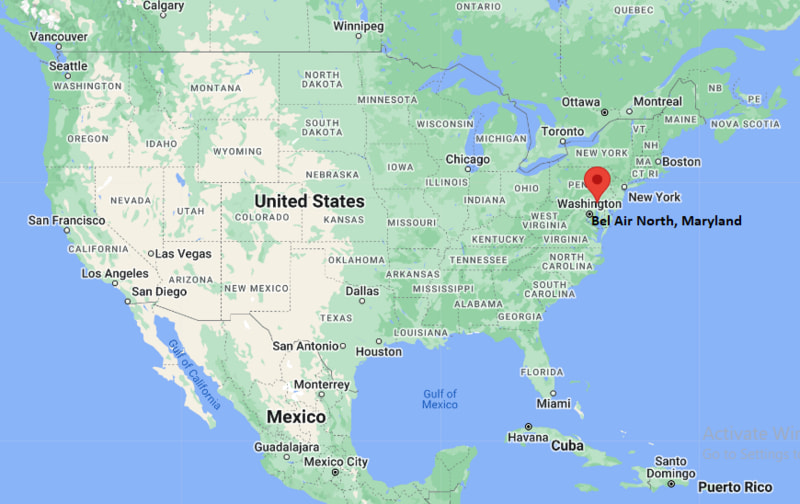
Bel Air North Map, Maryland, USA
Where is Bel Air North?: The Google Map showing the location of Bel Air North in the U.S. state of Maryland.
Where is Bel Air North Located?
Bel Air North is a census-designated place located in the Harford County of Maryland, United States. Bel Air North lies at approximately 39.55429 Degrees North latitude and -76.3731 Degrees West longitude. According to the 2020 U.S. Census, the population of Bel Air North CDP is 31,841 people and the community has a total area of 16.037 sq mi. The community has numerous parks and recreational facilities.
Most Viewed US Maps
| USA Sttae Map | USA Region Map | USA Road Map |
| USA County Map | Where is USA in World Map? | US ZIP Code Map |
| USA Time Zones Map | US State and Capitals Map | USA Physical Map |
Find 4,400+ U.S. Cities by State - Explore Their Locations and Get Detailed Information
Bel Air North, Maryland Quick Facts
| Fact | Details |
|---|---|
| Community | Bel Air North (Census-Designated Place) |
| County | Harford County |
| State | Maryland |
| State Capital | Annapolis |
| Country | United States |
| US Region | South |
| Latitude | 39.55429 N |
| Longitude | -76.3731 W |
| Elevation | 387 ft (118 m) |
| Land Area | 11.9 sq mi |
| Water Area | 0.1 sq mi |
| Total Area | 16.037 sq mi |
| Population (Census 2020) | 30,568 |
| Population Density | Approximately 2,570 per sq mi |
| ZIP Codes | 21014, 21015, 21050 |
| Area Code | 410, 443, 667 |
| Time Zone Standard | Eastern Standard Time (EST, UTC-5) |
| Time Zone Daylight | Eastern Daylight Time (EDT, UTC-4) |
| Currency | United States Dollar (USD) |
| FIPS Code | 24-05825 |
| Congressional District | Maryland's 2nd Congressional District |
Nearby Cities to Bel Air North, Maryland
- Bel Air, Maryland - 2 mi Southwest
- Fallston, Maryland - 5 mi West
- Forest Hill, Maryland - 5 mi Northwest
- Abingdon, Maryland - 8 mi South
- Riverside, Maryland - 9 mi South
- Edgewood, Maryland - 10 mi South
- Havre de Grace, Maryland - 16 mi East
- Perry Hall, Maryland - 17 mi Southwest
- Towson, Maryland - 22 mi Southwest
- Baltimore, Maryland - 28 mi Southwest
Bel Air North, Maryland Climate and Weather Overview
| Month | Avg High (°F) | Avg Low (°F) | Avg Rainfall (in) |
|---|---|---|---|
| January | 42 | 25 | 3.2 |
| April | 65 | 44 | 3.5 |
| July | 87 | 68 | 4.2 |
| October | 68 | 47 | 3.3 |
| Annual | 66 | 46 | 45.0 |
| Climate Attribute | Details |
|---|---|
| Climate Classification | Humid Subtropical (Köppen Cfa) |
| Annual Rainfall | Approximately 45 inches |
| Annual Sunshine Days | About 206 days |
| Hurricane/Tornado Risk | Low to Moderate - Occasional tropical systems and severe thunderstorms |
| Snowfall | Approximately 20 inches annually |
Driving Distances from Bel Air North, Maryland
| City | State | Distance (mi) | Approx. Drive Time |
|---|---|---|---|
| Bel Air | Maryland | 2 | 5 min |
| Fallston | Maryland | 5 | 10 min |
| Forest Hill | Maryland | 5 | 10 min |
| Abingdon | Maryland | 8 | 15 min |
| Riverside | Maryland | 9 | 16 min |
| Edgewood | Maryland | 10 | 18 min |
| Havre de Grace | Maryland | 16 | 22 min |
| Perry Hall | Maryland | 17 | 25 min |
| Towson | Maryland | 22 | 30 min |
| Baltimore | Maryland | 28 | 40 min |
Transportation and Connectivity in Bel Air North, Maryland
| Transportation | Details |
|---|---|
| Airport Name | Baltimore/Washington International Thurgood Marshall Airport |
| IATA Code | BWI |
| Port | Port of Baltimore (nearby) |
| Major Highways | U.S. Route 1, U.S. Route 40, Maryland Route 24, Interstate 95 (nearby) |
| Train/Amtrak Service | Nearest Amtrak station at Aberdeen |
| Local Bus/Transit Service | Harford Transit LINK and MTA Maryland commuter services |
- Maryland Route 24 - Main north-south highway connecting Bel Air North with Interstate 95, Bel Air and Harford County communities.
- U.S. Route 1 - Provides regional access to Baltimore, Bel Air and northeastern Maryland.
- U.S. Route 40 - Connects the community with Aberdeen, Elkton and eastern Maryland.
- Interstate 95 - Located a short drive away, offering direct access to Baltimore, Philadelphia and Washington, D.C.
Key Landmarks and Places to Visit in Bel Air North, Maryland
| Landmark | Type |
|---|---|
| Rockfield Manor | Historic Site |
| Ma & Pa Heritage Trail | Recreation Trail |
| Anita C. Leight Estuary Center | Nature Center |
| Harford Mall | Shopping Center |
| Liriodendron Mansion | Historic Mansion |
| Bynum Run Park | Community Park |
| Harford Vineyard & Winery | Winery |
| Jerusalem Mill Village | Historic Site |
| Friends Park | City Park |
| Harford Artists Gallery | Art Gallery |
Colleges and Universities in Bel Air North, Maryland
| Institution | Type | Level | Notable For |
|---|---|---|---|
| Harford Community College | Public | Community College | Career and transfer education |
| Towson University | Public | University | Education and business |
| University of Maryland, Baltimore County | Public | University | Research and engineering |
| Johns Hopkins University | Private | University | Research and medicine |
| Morgan State University | Public | University | Engineering and liberal arts |
| Cecil College | Public | Community College | Workforce development |
Waterbodies in Bel Air North, Maryland
Bynum Run, Winters Run, Bush River, Gunpowder Falls, Chesapeake Bay, Deer Creek, Broad Creek, Atkisson Reservoir, Swan Creek, Otter Point Creek.
Golf Courses in Bel Air North, Maryland
Maryland Golf and Country Clubs, Mountain Branch Golf Club, Bulle Rock Golf Course, Wetlands Golf Club, Geneva Farm Golf Course, Ruggles Golf Course, Greystone Golf Course, Fox Hollow Golf Course.
Bel Air North, Maryland - Key Historical Facts
- Bel Air North developed during the second half of the twentieth century as residential neighborhoods expanded beyond the Town of Bel Air.
- The community grew rapidly because of its convenient location near Interstate 95 and employment centers in Baltimore and Harford County.
- Much of the area was historically farmland before suburban housing developments transformed the landscape in the 1970s and 1980s.
- Its proximity to Aberdeen Proving Ground contributed to steady population growth and residential development.
- Bel Air North shares much of its cultural and commercial identity with neighboring Bel Air while remaining an unincorporated census-designated place.
- Today, the community is known for its parks, quality schools, shopping centers and easy access to the Chesapeake Bay region.
References
Maryland Related Maps and Info
- Where is Annapolis
- Where is Aspen Hill
- Where is Bel Air North
- Where is Bel Air South
- Where is Baltimore
- Where is Bethesda
- Where is Bowie
- Where is Carney
- Where is Catonsville
- Where is Chillum
- Where is Clarksburg
- Where is Clinton
- Where is College Park
- Where is Columbia
- Where is Crofton
- Where is Dundalk
- Where is Eldersburg
- Where is Elkridge
- Where is Ellicott City
- Where is Essex
- Where is Frederick
- Where is Gaithersburg
- Where is Germantown
- Where is Glen Burnie
- Where is Hagerstown
- Where is Laurel
- Where is Middle River
- Where is Milford Mill
- Where is Montgomery Village
- Where is North Bethesda
- Where is North Laurel
- Where is Odenton
- Where is Olney
- Where is Owings Mills
- Where is Parkville
- Where is Pasadena
- Where is Perry Hall
- Where is Pikesville
- Where is Potomac
- Where is Randallstown
- Where is Rockville
- Where is Salisbury
- Where is Severn
- Where is Severna Park
- Where is Silver Spring
- Where is South Laurel
- Where is Towson
- Where is Waldorf
- Where is Wheaton
- Where is Woodlawn