
Where is Elkridge Located? - Elkridge is a city located in the Howard County of Maryland, United States. Elkridge lies between 32.1793163 Degrees North latitudes and 90.2453671 Degrees West longitudes.
Location Map of Elkridge, Maryland
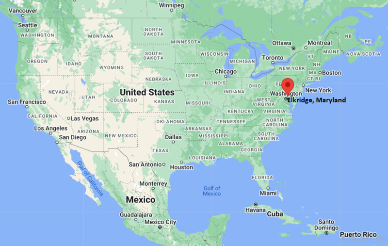
Elkridge Map, Maryland, USA
Where is Elkridge?: The Google Map showing the location of Elkridge in the U.S. state of Maryland.
Where is Elkridge Located?
Elkridge is a city located in the Howard County of Maryland, United States. Elkridge lies between 32.1793163 Degrees North latitudes and 90.2453671 Degrees West longitudes. According to 2020 U.S.census, the population of Elkridge city is 25171 people and the city has a total area of 8.39 sq mi. The city has numerous parks and recreational facilities.
Most Viewed US Maps
| USA Sttae Map | USA Region Map | USA Road Map |
| USA County Map | Where is USA in World Map? | US ZIP Code Map |
| USA Time Zones Map | US State and Capitals Map | USA Physical Map |
Find 4,400+ U.S. Cities by State - Explore Their Locations and Get Detailed Information
Elkridge, Maryland Quick Facts
| Property | Details |
|---|---|
| City | Elkridge (Census-designated place) |
| County | Howard County |
| State | Maryland |
| State Capital | Annapolis |
| US Region | South |
| Latitude | 39.2126°N |
| Longitude | 76.7136°W |
| Elevation | 151 ft (46 m) |
| Land Area | 8.40 sq mi |
| Water Area | 0.09 sq mi |
| Total Area | 8.49 sq mi |
| Population (2020 Census) | 25,171 |
| Population Density | Approximately 2,997 per sq mi |
| ZIP Code | 21075 |
| Area Code | 410, 443, 667 |
| Time Zone Standard | Eastern Standard Time (EST), UTC−5 |
| Time Zone Daylight | Eastern Daylight Time (EDT), UTC−4 |
| Currency | US Dollar (USD) |
| FIPS Code | 24-25775 |
| Congressional District | Maryland's 3rd Congressional District |
Nearby Cities to Elkridge, Maryland
- Hanover, Maryland - East - 4 mi
- Columbia, Maryland - West - 8 mi
- Jessup, Maryland - North - 3 mi
- Linthicum Heights, Maryland - Southeast - 7 mi
- Laurel, Maryland - Northeast - 10 mi
- Catonsville, Maryland - Northwest - 8 mi
- Baltimore, Maryland - Northeast - 13 mi
- Glen Burnie, Maryland - East - 12 mi
- Annapolis, Maryland - Southeast - 27 mi
- Washington, District of Columbia - Southwest - 31 mi
Elkridge, Maryland Climate and Weather Overview
| Month | Avg High (°F) | Avg Low (°F) | Avg Rainfall (in) |
|---|---|---|---|
| January | 43 | 27 | 3.20 |
| April | 66 | 45 | 3.40 |
| July | 88 | 69 | 4.00 |
| October | 69 | 49 | 3.30 |
| Annual | 67 | 48 | 43.20 |
| Climate Attribute | Details |
|---|---|
| Climate Classification (Köppen) | Humid Subtropical (Cfa) |
| Annual Rainfall | Approximately 43 inches |
| Annual Sunshine Days | About 206 days |
| Hurricane/Tornado Risk | Low hurricane risk; low tornado risk |
| Snowfall | Approximately 18 inches annually |
Driving Distances from Elkridge, Maryland
| City | State | Distance (mi) | Approx. Drive Time |
|---|---|---|---|
| Jessup | Maryland | 3 | 8 min |
| Hanover | Maryland | 4 | 10 min |
| Linthicum Heights | Maryland | 7 | 12 min |
| Columbia | Maryland | 8 | 15 min |
| Catonsville | Maryland | 8 | 15 min |
| Laurel | Maryland | 10 | 18 min |
| Glen Burnie | Maryland | 12 | 20 min |
| Baltimore | Maryland | 13 | 20 min |
| Annapolis | Maryland | 27 | 35 min |
| Washington | District of Columbia | 31 | 45 min |
Transportation and Connectivity in Elkridge, Maryland
| Transportation | Details |
|---|---|
| Airport Name | Baltimore/Washington International Thurgood Marshall Airport |
| IATA Code | BWI |
| Port | Port of Baltimore (nearby) |
| Major Highways | Interstate 95, Maryland Route 100, U.S. Route 1, Maryland Route 103 |
| Train/Amtrak Service | Nearby Amtrak and MARC service at BWI Rail Station |
| Local Bus/Transit Service | Regional Transportation Agency of Central Maryland (RTA) and MTA Maryland |
- Interstate 95 provides direct access to Baltimore, Washington, Philadelphia, and the Northeast Corridor.
- Maryland Route 100 connects Elkridge with Glen Burnie, Columbia, and surrounding suburban communities.
- U.S. Route 1 is a major commercial corridor serving businesses and residential neighborhoods throughout the area.
- Baltimore/Washington International Thurgood Marshall Airport, less than 10 miles away, offers extensive domestic and international air service.
Places to Visit in Elkridge, Maryland
| Landmark Name | Type |
|---|---|
| Patapsco Valley State Park | State Park |
| Thomas Viaduct | Historic Railroad Bridge |
| Rockburn Branch Park | County Park |
| Howard County Conservancy | Nature Center |
| Elkridge Furnace Inn | Historic Landmark |
| Historic Elkridge | Historic District |
| Troy Park at Elkridge | Community Park |
| Patapsco Female Institute Historic Park | Historic Site |
| Blandair Regional Park | Regional Park |
| National Electronics Museum | Museum |
Colleges and Universities in Elkridge, Maryland
| Institution Name | Type | Level | Notable For |
|---|---|---|---|
| Howard Community College | Public | Community College | Transfer degrees and workforce education |
| University of Maryland, Baltimore County | Public | University | Research, engineering, and computer science |
| University of Maryland, College Park | Public | University | Research and graduate programs |
| Johns Hopkins University | Private | University | Medicine, engineering, and research |
| Anne Arundel Community College | Public | Community College | Career and technical education |
| Baltimore City Community College | Public | Community College | Associate degree programs |
| Stevenson University | Private | University | Business, nursing, and education |
| Howard County Public School System | Public | K–12 District | Primary and secondary education |
Waterbodies in Elkridge, Maryland
Patapsco River, Deep Run, Rockburn Branch, Stony Run, Chesapeake Bay (nearby), Dorsey Run, Little Patuxent River, Cascade Falls
Golf Courses in Elkridge, Maryland
Timbers at Troy Golf Course, Diamond Ridge Golf Course, The Woodlands Golf Course, Hobbit's Glen Golf Club, Fairway Hills Golf Club, Forest Park Golf Course, Compass Pointe Golf Courses, Rolling Road Golf Club
Elkridge, Maryland — Key Historical Facts
- Elkridge was established in the early 18th century and is one of Maryland's oldest continuously settled communities.
- The town developed as a major milling and transportation center along the Patapsco River, benefiting from water-powered industries and trade.
- The historic Thomas Viaduct, completed in 1835, became the world's longest masonry railroad bridge at the time and remains an engineering landmark.
- During the 19th century, Elkridge expanded through agriculture, manufacturing, and railroad commerce, helping connect Baltimore with western Maryland.
- Its proximity to Baltimore and later Washington, D.C., transformed Elkridge into a growing suburban community during the second half of the 20th century.
- Today, Elkridge is known for its historic sites, parks, excellent transportation access, and thriving residential and business community within the Baltimore–Washington metropolitan area.
References
Maryland Related Maps and Info
- Where is Annapolis
- Where is Aspen Hill
- Where is Bel Air North
- Where is Bel Air South
- Where is Baltimore
- Where is Bethesda
- Where is Bowie
- Where is Carney
- Where is Catonsville
- Where is Chillum
- Where is Clarksburg
- Where is Clinton
- Where is College Park
- Where is Columbia
- Where is Crofton
- Where is Dundalk
- Where is Eldersburg
- Where is Elkridge
- Where is Ellicott City
- Where is Essex
- Where is Frederick
- Where is Gaithersburg
- Where is Germantown
- Where is Glen Burnie
- Where is Hagerstown
- Where is Laurel
- Where is Middle River
- Where is Milford Mill
- Where is Montgomery Village
- Where is North Bethesda
- Where is North Laurel
- Where is Odenton
- Where is Olney
- Where is Owings Mills
- Where is Parkville
- Where is Pasadena
- Where is Perry Hall
- Where is Pikesville
- Where is Potomac
- Where is Randallstown
- Where is Rockville
- Where is Salisbury
- Where is Severn
- Where is Severna Park
- Where is Silver Spring
- Where is South Laurel
- Where is Towson
- Where is Waldorf
- Where is Wheaton
- Where is Woodlawn