
Where is Waldorf Located? - Waldorf is a city located in the Waseca County of Maryland, United States. Waldorf lies between 45.2332984 Degrees North latitudes and 93.2913405 Degrees West longitudes.
Location Map of Waldorf, Maryland
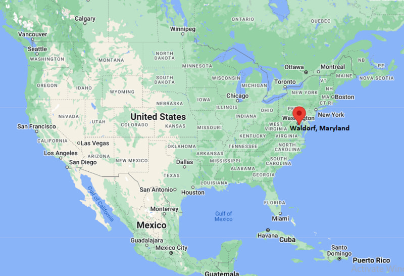
Waldorf Map, Maryland, USA
Where is Waldorf?: The Google Map showing the location of Waldorf in the U.S. state of Maryland.
Where is Waldorf Located?
Waldorf is a city located in the Waseca County of Minnesota, United States. Waldorf lies between 45.2332984 Degrees North latitudes and 93.2913405 Degrees West longitudes. According to 2020 U.S.census, the population of Waldorf city is 81410 people and the city has a total area of 36.26 sq mi. The city has numerous parks and recreational facilities.
Most Viewed US Maps
| USA Sttae Map | USA Region Map | USA Road Map |
| USA County Map | Where is USA in World Map? | US ZIP Code Map |
| USA Time Zones Map | US State and Capitals Map | USA Physical Map |
Find 4,400+ U.S. Cities by State - Explore Their Locations and Get Detailed Information
Waldorf, Maryland Quick Facts
| Attribute | Details |
|---|---|
| City | Waldorf |
| County | Charles County |
| State | Maryland |
| State Capital | Annapolis |
| US Region | Southern United States |
| Latitude | 38.6246° N |
| Longitude | 76.9395° W |
| Elevation | Approximately 180 ft (55 m) |
| Land Area | 36.5 sq mi |
| Water Area | 0.2 sq mi |
| Total Area | 36.7 sq mi |
| Population (2020 Census) | 75,448 |
| Population Density | Approximately 2,065 per sq mi |
| ZIP Codes | 20601, 20602, 20603, 20604, 20695 |
| Area Code | 301 |
| Time Zone Standard | Eastern Standard Time (EST), UTC−5 |
| Time Zone Daylight | Eastern Daylight Time (EDT), UTC−4 |
| Currency | United States Dollar (USD) |
| FIPS Code | 24-80625 |
| Community Type | Census-designated place (CDP) |
Transportation and Connectivity in Waldorf, Maryland
| Transportation | Details |
|---|---|
| Nearest Airport | Ronald Reagan Washington National Airport |
| IATA Code | DCA |
| Regional Airport | Baltimore/Washington International Thurgood Marshall Airport |
| Major Highways | US Route 301, Maryland Route 228, Maryland Route 5, Interstate 95 nearby |
| Rail Service | Amtrak and MARC Train service available in nearby Washington, D.C. and other regional stations |
| Bus Service | Charles County VanGO public transit system |
| Local Connectivity | Southern Maryland location with access to Washington, D.C., Alexandria, and Charles County communities |
- US Route 301 — Major north-south highway connecting Waldorf with Southern Maryland and Virginia.
- Maryland Route 5 — Important route connecting Waldorf with St. Charles, Leonardtown, and southern Maryland areas.
- Maryland Route 228 — Provides local connections to Indian Head and surrounding communities.
Top Places to Visit in Waldorf, Maryland
| Landmark Name | Type |
|---|---|
| Dr. Samuel Mudd House Museum | Historic Museum |
| St. Charles Towne Center | Shopping Center |
| Pinefield Community Park | Public Park |
| White Plains Regional Park | Recreation Area |
| Regency Furniture Stadium | Sports Facility |
| Blue Crabs Stadium | Baseball Stadium |
| Smallwood State Park | State Park |
| Port Tobacco Village Historic District | Historic District |
| Southern Maryland Blue Crabs Stadium | Sports Venue |
| Thomas Stone National Historic Site | Historic Site |
Driving Distances from Waldorf, Maryland to Nearby Cities
| City | State | Distance (mi) | Approx. Drive Time |
|---|---|---|---|
| Washington, D.C. | District of Columbia | 25 mi | 45 minutes |
| Alexandria | Virginia | 28 mi | 50 minutes |
| Annapolis | Maryland | 45 mi | 1 hour |
| Baltimore | Maryland | 65 mi | 1 hour 20 minutes |
| Fredericksburg | Virginia | 55 mi | 1 hour 10 minutes |
| Richmond | Virginia | 100 mi | 1 hour 50 minutes |
| Hagerstown | Maryland | 110 mi | 2 hours |
| Philadelphia | Pennsylvania | 130 mi | 2 hours 30 minutes |
| Virginia Beach | Virginia | 150 mi | 2 hours 45 minutes |
| New York City | New York | 240 mi | 4 hours |
Colleges and Universities Near Waldorf, Maryland
| Institution Name | Type | Level | Notable For |
|---|---|---|---|
| College of Southern Maryland | Public | Community College | Associate degrees, workforce training, nursing, technology, and transfer programs |
| University of Maryland Global Campus | Public | University | Online education, business, cybersecurity, and professional programs |
| George Washington University | Private | University | Law, medicine, international affairs, business, and research |
| Georgetown University | Private | University | Law, business, public policy, and international studies |
| University of Maryland, College Park | Public | University | Engineering, sciences, business, education, and research |
Waterbodies Near Waldorf, Maryland
Mattawoman Creek, Potomac River, Piscataway Creek, Port Tobacco River, and nearby Chesapeake Bay tributaries provide opportunities for fishing, boating, kayaking, wildlife viewing, and outdoor recreation.
Golf Courses and Stadiums Near Waldorf
Golf Courses: White Plains Golf Course, Swan Point Yacht & Country Club, and Breton Bay Golf & Country Club. Stadiums and sports facilities include Regency Furniture Stadium, Waldorf Jaycees Community Center athletic facilities, and local Charles County recreation complexes.
Key Landmarks and Places to Visit in Waldorf, Maryland
| Landmark Name | Type |
|---|---|
| Dr. Samuel Mudd House Museum | Historic Museum |
| Thomas Stone National Historic Site | National Historic Site |
| Port Tobacco Village Historic District | Historic District |
| Smallwood State Park | State Park |
| Regency Furniture Stadium | Sports Venue |
| St. Charles Towne Center | Shopping Center |
| White Plains Regional Park | Recreation Area |
| Pinefield Community Park | Public Park |
| Mattawoman Creek | Natural Area |
| Southern Maryland Blue Crabs Stadium | Baseball Stadium |
Waldorf, Maryland — Key Historical Facts
- The Waldorf area was originally inhabited by Native American groups, including communities connected to the Piscataway people.
- The community was first known as Beantown before being renamed Waldorf in the 19th century.
- Waldorf was named after William Waldorf Astor, a member of the prominent Astor family.
- The arrival of the railroad in the late 19th century helped Waldorf develop as a local trading and transportation center.
- During the early 20th century, Waldorf became known for tobacco farming, agriculture, and rural commerce.
- The area experienced major population growth after World War II as suburban development expanded from the Washington, D.C. metropolitan region.
- Waldorf became one of Southern Maryland’s largest population centers with new residential communities, shopping areas, and businesses.
- Today, Waldorf is known for its suburban neighborhoods, historic sites, regional shopping, parks, and location near Washington, D.C.
References
- United States Census Bureau
- Charles County Government Official Website
- State of Maryland Official Website
- Thomas Stone National Historic Site - National Park Service
- Maryland Tourism
Maryland Related Maps and Info
- Where is Annapolis
- Where is Aspen Hill
- Where is Bel Air North
- Where is Bel Air South
- Where is Baltimore
- Where is Bethesda
- Where is Bowie
- Where is Carney
- Where is Catonsville
- Where is Chillum
- Where is Clarksburg
- Where is Clinton
- Where is College Park
- Where is Columbia
- Where is Crofton
- Where is Dundalk
- Where is Eldersburg
- Where is Elkridge
- Where is Ellicott City
- Where is Essex
- Where is Frederick
- Where is Gaithersburg
- Where is Germantown
- Where is Glen Burnie
- Where is Hagerstown
- Where is Laurel
- Where is Middle River
- Where is Milford Mill
- Where is Montgomery Village
- Where is North Bethesda
- Where is North Laurel
- Where is Odenton
- Where is Olney
- Where is Owings Mills
- Where is Parkville
- Where is Pasadena
- Where is Perry Hall
- Where is Pikesville
- Where is Potomac
- Where is Randallstown
- Where is Rockville
- Where is Salisbury
- Where is Severn
- Where is Severna Park
- Where is Silver Spring
- Where is South Laurel
- Where is Towson
- Where is Waldorf
- Where is Wheaton
- Where is Woodlawn