
Where is Severn Located? - Severn is a city located in the Anne Arundel County of Maryland, United States. Severn lies between 45.303218 Degrees North latitudes and 93.5547381 Degrees West longitudes.
Location Map of Severn, Maryland
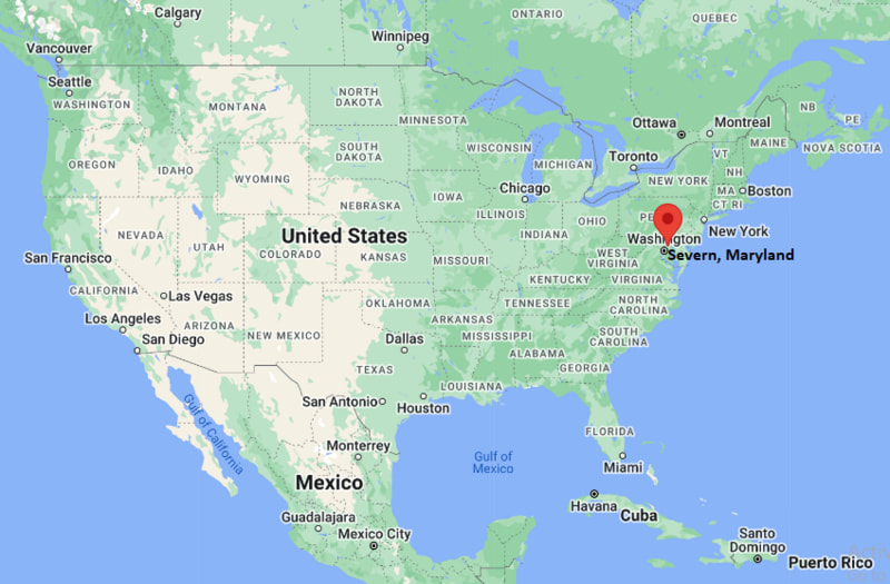
Severn Map, Maryland, USA
Where is Severn?: The Google Map showing the location of Severn in the U.S. state of Maryland.
Where is Severn Located?
Severn is a city located in the Anne Arundel County of Maryland, United States. Severn lies between 45.303218 Degrees North latitudes and 93.5547381 Degrees West longitudes. According to 2020 U.S.census, the population of Severn city is 57118 people and the city has a total area of 18.32 sq mi. The city has numerous parks and recreational facilities.
Most Viewed US Maps
| USA Sttae Map | USA Region Map | USA Road Map |
| USA County Map | Where is USA in World Map? | US ZIP Code Map |
| USA Time Zones Map | US State and Capitals Map | USA Physical Map |
Find 4,400+ U.S. Cities by State - Explore Their Locations and Get Detailed Information
Severn, Maryland Quick Facts
| Attribute | Details |
|---|---|
| City | Severn |
| County | Anne Arundel County |
| State | Maryland |
| State Capital | Annapolis |
| US Region | Northeastern United States |
| Latitude | 39.1371° N |
| Longitude | 76.6983° W |
| Elevation | 95 ft (29 m) |
| Land Area (sq mi) | 18.35 |
| Water Area (sq mi) | 0.03 |
| Total Area (sq mi) | 18.38 |
| Population (2020 Census) | 57,118 |
| Population Density (per sq mi) | 3,111.1 |
| ZIP Codes | 21113, 21144 |
| Area Code | 410, 443, 667 |
| Time Zone Standard | Eastern Standard Time (EST), UTC−5 |
| Time Zone Daylight | Eastern Daylight Time (EDT), UTC−4 |
| Currency | United States Dollar (USD) |
| FIPS Code | 2472300 |
| Congressional District | 3rd Congressional District |
Transportation and Connectivity in Severn
| Transportation Feature | Details |
|---|---|
| Airport Name | Baltimore/Washington International Thurgood Marshall Airport |
| IATA Code | BWI |
| Port | Port of Baltimore and Chesapeake Bay maritime facilities |
| Major Highways | Interstate 97, Interstate 695, Maryland Route 100, Maryland Route 170, and U.S. Route 1 |
| Train/Amtrak Service | Nearby MARC and Amtrak service is available at BWI Rail Station. |
| Local Bus/Transit Service | Maryland Transit Administration and Anne Arundel County transit services provide regional transportation connections. |
- Interstate 97 runs north-south through the area and connects Severn with Annapolis, Glen Burnie, and Baltimore.
- Interstate 695, the Baltimore Beltway, provides access around the Baltimore metropolitan area and connects with major regional highways.
- Maryland Route 100 connects Severn with Ellicott City, Glen Burnie, and major employment areas in Anne Arundel County.
- Maryland Route 170 provides a north-south connection between Severn, Linthicum, and Baltimore/Washington International Airport.
- U.S. Route 1 provides local access between Severn, Elkridge, Jessup, and nearby communities.
Top Places to Visit in Severn, Maryland
| Landmark Name | Type |
|---|---|
| BWI Trail | Recreation Trail |
| Baltimore/Washington International Airport Observation Areas | Airport Attraction |
| Fort Smallwood Park | Park |
| Thomas A. Dixon Jr. Aircraft Observation Area | Observation Area |
| Severn Run Natural Environment Area | Nature Preserve |
| Patuxent Research Refuge | Wildlife Refuge |
| Quiet Waters Park | Park |
| National Cryptologic Museum | Museum |
| Arundel Mills | Shopping Center |
| Historic London Town and Gardens | Historic Site |
Driving Distances from Severn, Maryland to Nearby Cities
| City | State | Distance (mi) | Approx. Drive Time |
|---|---|---|---|
| Glen Burnie | Maryland | 8 | 15 min |
| Elkridge | Maryland | 10 | 15 min |
| Columbia | Maryland | 15 | 25 min |
| Annapolis | Maryland | 20 | 30 min |
| Baltimore | Maryland | 18 | 30 min |
| Washington | District of Columbia | 35 | 50 min |
| Rockville | Maryland | 45 | 55 min |
| Frederick | Maryland | 55 | 1 hr |
| Dover | Delaware | 80 | 1 hr 30 min |
| Philadelphia | Pennsylvania | 110 | 2 hr |
Colleges and Universities in Severn, Maryland
| Institution Name | Type | Level | Notable For |
|---|---|---|---|
| Anne Arundel Community College | Public | Community College | Career training and associate degrees |
| University of Maryland, Baltimore County | Public | University | Research, science, and technology programs |
| University of Maryland, College Park | Public | University | Research and academic programs |
| United States Naval Academy | Public | University | Naval officer education and training |
Waterbodies in Severn, Maryland
Severn Run, Severn River, Chesapeake Bay, Patuxent River, Little Patuxent River
Golf Courses in Severn, Maryland
Compass Pointe Golf Courses, Timbers at Troy Golf Course, Walden Country Club, Eisenhower Golf Course
Key Landmarks and Places to Visit in Severn, Maryland
| Landmark Name | Type |
|---|---|
| Severn Run Natural Environment Area | Nature Preserve |
| BWI Trail | Recreation Trail |
| Thomas A. Dixon Jr. Aircraft Observation Area | Observation Area |
| Fort Smallwood Park | Park |
| Patuxent Research Refuge | Wildlife Refuge |
| National Cryptologic Museum | Museum |
| Arundel Mills | Shopping Center |
| Quiet Waters Park | Park |
| Historic London Town and Gardens | Historic Site |
| Severn River | Natural Attraction |
Waterbodies in Severn, Maryland
Severn Run, Severn River, Chesapeake Bay, Patuxent River, Little Patuxent River
Golf Courses in Severn, Maryland
Compass Pointe Golf Courses, Timbers at Troy Golf Course, Walden Country Club, Eisenhower Golf Course
Severn, Maryland — Key Historical Facts
- Severn developed in Anne Arundel County near important waterways and transportation routes connecting Baltimore and Annapolis.
- The area takes its name from the Severn River, which was named by English settlers during the colonial period.
- Severn grew from a rural community into a suburban area as residential development expanded across Anne Arundel County.
- The opening of Baltimore/Washington International Airport nearby helped increase regional growth and transportation connections.
- Severn's location between Baltimore and Washington, D.C., has made it an important residential community within the Baltimore-Washington metropolitan area.
References
- Anne Arundel County Government
- U.S. Census Bureau
- Maryland Department of Natural Resources
- Baltimore/Washington International Thurgood Marshall Airport
- Severn Run Natural Environment Area — Anne Arundel County
- Anne Arundel Community College
Maryland Related Maps and Info
- Where is Annapolis
- Where is Aspen Hill
- Where is Bel Air North
- Where is Bel Air South
- Where is Baltimore
- Where is Bethesda
- Where is Bowie
- Where is Carney
- Where is Catonsville
- Where is Chillum
- Where is Clarksburg
- Where is Clinton
- Where is College Park
- Where is Columbia
- Where is Crofton
- Where is Dundalk
- Where is Eldersburg
- Where is Elkridge
- Where is Ellicott City
- Where is Essex
- Where is Frederick
- Where is Gaithersburg
- Where is Germantown
- Where is Glen Burnie
- Where is Hagerstown
- Where is Laurel
- Where is Middle River
- Where is Milford Mill
- Where is Montgomery Village
- Where is North Bethesda
- Where is North Laurel
- Where is Odenton
- Where is Olney
- Where is Owings Mills
- Where is Parkville
- Where is Pasadena
- Where is Perry Hall
- Where is Pikesville
- Where is Potomac
- Where is Randallstown
- Where is Rockville
- Where is Salisbury
- Where is Severn
- Where is Severna Park
- Where is Silver Spring
- Where is South Laurel
- Where is Towson
- Where is Waldorf
- Where is Wheaton
- Where is Woodlawn