
Where is Pikesville Located? - Pikesville is a city located in the Baltimore County of Maryland, United States. Pikesville lies between 32.2788733 Degrees North latitudes and 90.001384 Degrees West longitudes.
Location Map of Pikesville, Maryland
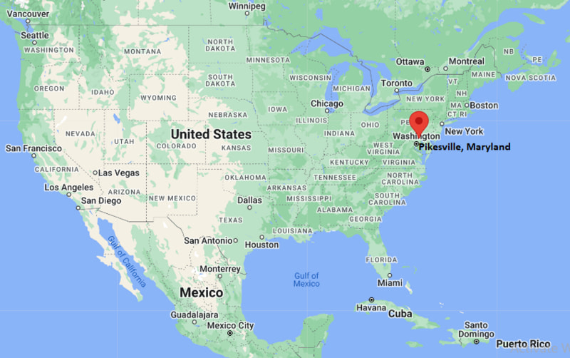
Pikesville Map, Maryland, USA
Where is Pikesville?: The Google Map showing the location of Pikesville in the U.S. state of Maryland.
Where is Pikesville Located?
Pikesville is a city located in the Baltimore County of Maryland, United States. Pikesville lies between 32.2788733 Degrees North latitudes and 90.001384 Degrees West longitudes. According to 2020 U.S.census, the population of Pikesville city is 34168 people and the city has a total area of 12.35 sq mi. The city has numerous parks and recreational facilities.
Most Viewed US Maps
| USA Sttae Map | USA Region Map | USA Road Map |
| USA County Map | Where is USA in World Map? | US ZIP Code Map |
| USA Time Zones Map | US State and Capitals Map | USA Physical Map |
Find 4,400+ U.S. Cities by State - Explore Their Locations and Get Detailed Information
Pikesville, Maryland Quick Facts
| Attribute | Details |
|---|---|
| City | Pikesville (Census-designated place) |
| County | Baltimore County |
| State | Maryland |
| State Capital | Annapolis |
| US Region | Southern United States (South Atlantic Region) |
| Latitude | 39.3746° N |
| Longitude | 76.7222° W |
| Elevation | 482 ft (147 m) |
| Land Area | 12.35 sq mi |
| Water Area | 0.00 sq mi |
| Total Area | 12.35 sq mi |
| Population (2020 Census) | 34,168 |
| Population Density | Approximately 2,767 people per sq mi |
| ZIP Codes | 21208, 21282 |
| Area Code | 410, 443, 667 |
| Time Zone Standard | Eastern Standard Time (EST, UTC−5) |
| Time Zone Daylight | Eastern Daylight Time (EDT, UTC−4) |
| Currency | United States Dollar (USD) |
| FIPS Code | 24-61400 |
| Congressional District | Maryland's 7th Congressional District |
Transportation and Connectivity in Pikesville
| Category | Details |
|---|---|
| Airport Name | Baltimore/Washington International Thurgood Marshall Airport |
| IATA Code | BWI |
| Port | Port of Baltimore (regional access) |
| Major Highways | Interstate 695, Interstate 795, Reisterstown Road (MD 140), Greenspring Avenue, Interstate 83 (nearby) |
| Train/Amtrak Service | Nearest Amtrak service at Baltimore Penn Station |
| Local Bus/Transit Service | Maryland Transit Administration (MTA) Metro SubwayLink and Local Bus services |
- Interstate 695 (Baltimore Beltway) – Encircles Baltimore and provides access to major suburbs and regional highways.
- Interstate 795 – Connects Pikesville with Owings Mills and northwestern Baltimore County.
- Maryland Route 140 (Reisterstown Road) – Primary commercial corridor linking Pikesville with Baltimore and Reisterstown.
- Interstate 83 – Nearby interstate providing direct access to downtown Baltimore and south-central Pennsylvania.
Top Places to Visit in Pikesville, Maryland
| Landmark Name | Type |
|---|---|
| Oregon Ridge Park | County Park |
| Cylburn Arboretum | Arboretum |
| Greenspring Valley | Scenic Area |
| Baltimore Hebrew Congregation | Historic Religious Site |
| The Shops at Quarry Lake | Shopping Center |
| Milford Mill Park | Community Park |
| Pikesville Armory | Historic Landmark |
| Irvine Nature Center | Nature Center |
| Woodholme Country Club | Country Club |
| Soldiers Delight Natural Environment Area | Nature Preserve |
Driving Distances from Pikesville, Maryland to Nearby Cities
| City | State | Distance (mi) | Approx. Drive Time |
|---|---|---|---|
| Baltimore | Maryland | 10 | 20 minutes |
| Towson | Maryland | 9 | 20 minutes |
| Owings Mills | Maryland | 7 | 15 minutes |
| Catonsville | Maryland | 9 | 20 minutes |
| Ellicott City | Maryland | 15 | 25 minutes |
| Westminster | Maryland | 24 | 35 minutes |
| Annapolis | Maryland | 37 | 45 minutes |
| Columbia | Maryland | 22 | 30 minutes |
| Washington | District of Columbia | 42 | 1 hour |
| York | Pennsylvania | 49 | 1 hour |
Colleges and Universities in Pikesville, Maryland
| Institution Name | Type | Level | Notable For |
|---|---|---|---|
| Stevenson University – Owings Mills Campus | Private | University | Health sciences and business programs |
| Baltimore City Community College | Public | Community College | Career and transfer education |
| Towson University | Public | University | Teacher education and research |
| Johns Hopkins University | Private | University | Medical and scientific research |
| Morgan State University | Public | University | Engineering and liberal arts |
| Baltimore County Public Schools | Public | K–12 District | Primary and secondary education |
Waterbodies in Pikesville, Maryland
Jones Falls, Gwynns Falls, Dead Run, Lake Roland, Quarry Lake, Liberty Reservoir, Greenspring Valley streams.
Golf Courses in Pikesville
Woodholme Country Club, Suburban Club, Diamond Ridge Golf Course, Forest Park Golf Course, Pine Ridge Golf Course, Greystone Golf Course.
Pikesville, Maryland — Key Historical Facts
- Pikesville was established in the early nineteenth century along the historic Reisterstown Turnpike, an important transportation route connecting Baltimore with central Maryland.
- The community was named after explorer and military officer Zebulon Pike, whose family owned land in the area during its early development.
- During the twentieth century, Pikesville grew from a rural crossroads into one of Baltimore County's largest suburban communities.
- Pikesville has long been recognized for its vibrant Jewish community, which has played a significant role in the area's cultural, educational, and religious life.
- Today, Pikesville is known for its residential neighborhoods, excellent schools, shopping districts, and convenient access to downtown Baltimore and surrounding communities.
References
- Baltimore County Government
- U.S. Census Bureau
- Maryland Department of Natural Resources
- Visit Maryland
- Maryland Transit Administration
Maryland Related Maps and Info
- Where is Annapolis
- Where is Aspen Hill
- Where is Bel Air North
- Where is Bel Air South
- Where is Baltimore
- Where is Bethesda
- Where is Bowie
- Where is Carney
- Where is Catonsville
- Where is Chillum
- Where is Clarksburg
- Where is Clinton
- Where is College Park
- Where is Columbia
- Where is Crofton
- Where is Dundalk
- Where is Eldersburg
- Where is Elkridge
- Where is Ellicott City
- Where is Essex
- Where is Frederick
- Where is Gaithersburg
- Where is Germantown
- Where is Glen Burnie
- Where is Hagerstown
- Where is Laurel
- Where is Middle River
- Where is Milford Mill
- Where is Montgomery Village
- Where is North Bethesda
- Where is North Laurel
- Where is Odenton
- Where is Olney
- Where is Owings Mills
- Where is Parkville
- Where is Pasadena
- Where is Perry Hall
- Where is Pikesville
- Where is Potomac
- Where is Randallstown
- Where is Rockville
- Where is Salisbury
- Where is Severn
- Where is Severna Park
- Where is Silver Spring
- Where is South Laurel
- Where is Towson
- Where is Waldorf
- Where is Wheaton
- Where is Woodlawn